Letizia Artioli, Pietro Costa, Giovanni Borga (2026). Hydro Digital Twins as Emerging Technologies: An alluvial mapping of objectives across marine, coastal, and freshwater applications. In: Human Interaction and Emerging Technologies (IHIET 2026). AHFE Open Access, vol. 236, pp. 531–537. https://doi.org/10.54941/ahfe1008128
Water territories (coastal zones, river corridors, marine basins, and lagoons) face compounding climate pressures, yet the digital tools designed to support their governance remain poorly understood in terms of what they actually aim to achieve. While Hydro Digital Twins (HDTs) are increasingly framed as instruments for climate adaptation and environmental stewardship, systematic analyses of their governance purpose remain scarce. This paper examines 14 HDT applications spanning marine, coastal, river-lake-fjord, aquaculture, and flooding domains, published between 2020 and 2025. Rather than cataloguing technical features, the analysis traces how application contexts translate into governance functions and, in turn, into concrete operational targets. An alluvial diagram links five application themes (left) to six governance-function categories: Forecasting, Modelling, Monitoring, and their combinations (centre)—and onward to 18 specific objectives (right). Three patterns emerge. First, monitoring, forecasting, and modelling functions overlap substantially across themes, revealing that HDTs are conceived as multi-functional instruments rather than single-purpose tools. Second, coastal applications exhibit the broadest governance scope, spanning spatial planning, erosion management, and environmental assessment simultaneously. Third, several objectives (saltwater intrusion management, biological component integration, participatory governance) appear as isolated, single-flow connections, signalling emergent but not yet consolidated research fronts. The paper argues that these governance flows expose both the promise and the fragility of current HDT architectures: broad ambition coexists with narrow implementation, and the distance from stated objective to operational deployment remains the defining challenge. Governance ambition has outpaced delivery capacity; institutional and data-governance frameworks such as F.A.I.R., C.A.R.E., and T.R.U.S.T. must develop alongside technical infrastructure if HDTs are to serve as instruments of equitable water-territory management.
Coastal zones, river corridors, and marine basins are among the territories most exposed to cascading climate hazards (IPCC, 2023). Over the past five years, Digital Twin (DT) technologies have been proposed as instruments Received June 12, 2026; Revised June 22, 2026; Accepted July 3, 2026; Available online August 25, 2026
capable of bridging the gap between environmental observation and governance action in these domains (Blair, 2021; Durden, 2025). Under labels such as Digital Twins of the Ocean, Coastal Zone DTs, or Water DTs, these systems aim to couple real-time data with simulation capacity to inform decisions on flood risk, erosion, pollution, and spatial planning (Henriksen et al., 2022; Tzachor et al., 2023). The European Digital Twin of the Ocean (EDITO) initiative exemplifies this ambition at institutional scale (Calewaert et al., 2024).
Yet a recurrent finding in the literature is that the stated governance purpose of these systems rarely receives the same analytical scrutiny as their data architectures or modelling pipelines (De Koning et al., 2024). Reviews tend to classify HDTs by what data they ingest or what models they run, rather than by what governance function they are designed to fulfil. This leaves a gap: we know relatively well how water DTs are built, but considerably less about why they are built, for whom, and toward what policy ends.
This paper addresses that gap through a single analytical device: an alluvial diagram that maps 14 HDT implementations from their application context, through their governance function, to their specific operational objective. The aim is not to assess technical performance but to render visible the governance logic embedded in current water DT research, and to identify where that logic converges, diverges, or breaks down.
METHODOLOGY
The 14 papers analysed here were drawn from a parent corpus of 117 environmental DT publications assembled following PRISMA-ScR guidelines (Tricco et al., 2018). The parent search covered Scopus and Google Scholar (January 2020–June 2025) using the term “digital twin” combined with water-domain keywords (“sea”, “coastal”, “river”, “lake”, “marine”, “lagoon”). From the parent corpus, papers were retained if they described an operational or prototype DT deployed within a water environment and reported at least one classifiable governance objective. A subset of 14 papers met the additional criterion of stating both a governance-level objective and at least one operationally specific target, enabling the three-column alluvial mapping presented below.
Each paper was coded along three axes: (1) Application Theme (Aquaculture, River/Lake/Fjord, Flooding, Coastal, Marine); (2) Governance Function (Forecasting, Modelling, Monitoring, and their pairwise combinations); (3) Specific Objective (the concrete operational or research target stated by the authors). Coding was performed by a single researcher with iterative consistency checks on borderline assignments. The alluvial diagram was generated using RAWGraphs 2.0.
RESULTS AND DISCUSSION
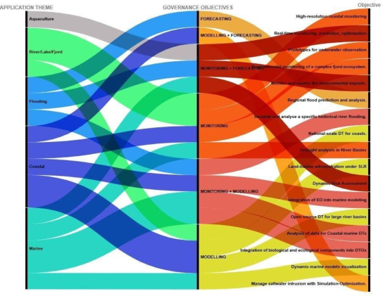
Reading the Alluvial Flows The diagram (Figure 1) arranges the 14 HDT implementations into three aligned columns. On the left, five application themes group the papers by water domain. In the centre, six governance-function categories—Forecasting;
Hydro Digital Twins as Emerging Technologies 533 Modelling + Forecasting; Monitoring + Forecasting; Monitoring; Monitoring + Modelling; and Modelling—capture the primary operational mode each DT is designed to serve. On the right, 18 specific objectives record the concrete targets declared by the authors, from high-resolution coastal monitoring to saltwater intrusion management. The width of each connecting band is proportional to the number of papers sharing that pathway.
Figure 1: Alluvial diagram of governance objectives (central column) distribution across application themes (left column), and specific objectives variations (right column).
Cross-Theme Convergence The most striking feature of the diagram is how extensively the governance functions overlap across themes. Monitoring + Forecasting, for instance, attracts flows from four of the five application themes (Coastal, River/Lake/ Fjord, Flooding, and Marine), showing that the coupling of observational and predictive capacity is a near-universal design requirement regardless of water domain. Similarly, the Modelling + Forecasting node draws connections from Aquaculture, Coastal, and Marine themes, reflecting the shared need for scenario-based intelligence in domains where decisions carry long lead times (spatial planning, aquaculture cycle management, climate adaptation).
This convergence carries a practical implication: common data standards and interoperable modelling platforms would benefit the majority of HDT deployments, since the governance functions they serve are structurally similar even when the physical environments differ. The current absence of such standards (Calewaert et al., 2024) effectively forces each project to build its monitoring-forecasting pipeline from scratch, limiting scalability.
Theme-Specific Governance Profiles Despite the convergence, each theme retains a distinctive governance signature. Coastal applications generate the widest fan of outgoing flows, connecting to objectives that range from high-resolution monitoring and national-scale DT
prototypes to land-marine property administration under sea-level rise. This breadth reflects the multifunctional governance mandate of the coastal zone, where hazard management, biodiversity conservation, spatial planning, and infrastructure regulation coexist within the same jurisdictional space.
Flooding, by contrast, channels its flows almost exclusively toward Monitoring and Forecasting, terminating in two tightly focused objectives: regional flood prediction and historical flood event simulation. This concentration mirrors the operational, actuarial logic that has historically driven DT adoption in hydrological risk contexts, where the value proposition is direct and quantifiable.
Marine applications exhibit a different profile: their flows spread across Monitoring, Monitoring + Modelling, and Modelling, terminating in objectives such as EO-model integration, biological component incorporation into DTOs, and dynamic marine model visualisation. The breadth here is not governance-driven (as in the coastal case) but epistemologically driven— these projects are constructing the foundational observational and modelling infrastructures that future governance applications will depend on.
Emergent and Isolated Objectives Several right-column entries appear as single, thin flows—connected to only one governance function from one application theme. Saltwater intrusion management, drought analysis in river basins, and the integration of biological and ecological components into DTOs each represent objectives that have entered the HDT research space but lack the multi-pathway redundancy that characterises more established targets. These isolates are analytically significant: they mark the expanding perimeter of what HDTs are expected to accomplish, but also the points where the evidence base is thinnest and the risk of fragmentation highest.
Equally notable is the objective labelled “enabling participatory and anticipatory governance,” which appears as a single flow from the River/ Lake/Fjord theme through Monitoring + Modelling. Despite being a stated priority of EDITO and the UN Ocean Decade (European Commission, 2020), participatory governance functions as an isolated target within the current corpus rather than a cross-cutting design principle. This mismatch between policy rhetoric and implementation practice is consistent with findings on the marginal role of citizen science data in HDT pipelines (Blair et al., 2019).
From Objectives to Implementation: The Remaining Distance The alluvial structure makes visible a further asymmetry: the left-to-centre connections (theme → function) are wide and well-distributed, suggesting that the field has successfully articulated what governance functions HDTs should serve. The centre-to-right connections (function → specific objective), however, are narrower and more fragmented, indicating that the translation from governance function to concrete, implementable target remains uneven. The distance between “Monitoring + Forecasting” as a stated function and “regional flood prediction and analysis” as a demonstrated capability is not
Hydro Digital Twins as Emerging Technologies 535 merely technical; it involves institutional alignment, data access agreements, computational infrastructure, and sustained funding—none of which are captured in the diagram but all of which determine whether the depicted flows materialise as operational systems.
CONCLUSION
This paper has used an alluvial diagram as an analytical lens to map the governance logic of 14 Hydro Digital Twin deployments across water territories. Three conclusions emerge.
The first is structural: HDTs across marine, coastal, and freshwater domains converge on a shared set of governance functions—monitoring, forecasting, and modelling—that transcend domain boundaries. This convergence represents an opportunity for cross-domain standardisation that is currently unrealised.
The second is diagnostic: the widening gap between the breadth of stated governance functions (centre column) and the specificity of operational targets (right column) reveals that the field’s ambition has outpaced its delivery. Coastal applications, despite their governance complexity, produce the most varied and granular objectives; flooding applications, despite their operational maturity, remain narrowly scoped. Neither pattern is inherently problematic, but together they indicate that no single HDT model yet integrates the full monitoring-modelling-governance chain from observation to policy action.
The third is prospective: the isolated, single-flow objectives at the diagram’s periphery: participatory governance, biological integration, saltwater intrusion, might suggest the next wave of HDT research. Whether these frontier objectives consolidate into established governance functions or remain marginal will depend on whether the institutional, ethical, and data- governance infrastructure—articulated through frameworks such as F.A.I.R. (Wilkinson et al., 2016), C.A.R.E. (Carroll et al., 2021), and T.R.U.S.T. (Lin et al., 2020)—is built in parallel with the technical capacity.
ACKNOWLEDGMENT
The authors acknowledge the use of Claude for language and syntax revision.
REFERENCES
Abdul Rahman, A., Kalantari, M. and Rajabifard, A. (2024). 3D Land–Marine Properties Administration in the Context of Sea Level Rise Using a Digital Twin Framework. The International Archives of the Photogrammetry, Remote Sensing and Spatial Information Sciences, XLVIII-4/W9-2024, 1–8. https://doi. org/10.5194/isprs-archives-XLVIII-4-W9-2024-1-2024 Allen, T., Chen, Y.-H., Steiner, B. et al. (2024). An Open Data Cube Platform as a
Coastal Digital Twin: Prototypes to Inform Flooding and Environmental Health. In: IEEE International Geoscience and Remote Sensing Symposium (IGARSS 2024), pp. 2322–2325. https://doi.org/10.1109/IGARSS53475.2024.10641339 Barbie, A., Pech, N., Hasselbring, W. et al. (2022). Developing an Underwater Network of Ocean Observation Systems with Digital Twin Prototypes—A Field Report from the Baltic Sea. IEEE Internet Computing, 26(3), 33–42. https://doi. org/10.1109/MIC.2021.3065245
Blair, G. S. (2021). Digital twins of the natural environment. Patterns, 2(10), 100359.
https://doi.org/10.1016/j.patter.2021.100359 Blair, G. S., Henrys, P., Leeson, A., Watkins, J., Eastoe, E., Jarvis, S. and Young, P. J.
(2019). Data Science of the Natural Environment: A Research Roadmap. Frontiers in Environmental Science, 7, 121. https://doi.org/10.3389/fenvs.2019.00121 Calewaert, J.-B., Staneva, J. and Le Traon, P. Y. (2024). EDITO: The European Digital Twin of the Ocean. EU Digital Governance Report. Carroll, S. R., Herczog, E., Hudson, M., Russell, K. and Stall, S. (2021).
Operationalizing the CARE and FAIR Principles for Indigenous Data Futures. Scientific Data, 8(1), 108. https://doi.org/10.1038/s41597-021-00892-0 De Koning, K., Broekhuijsen, J. et al. (2024). From Digital Twins to Ecological Digital Twins: Opportunities and Challenges. Ecological Informatics, 82, 102708. Duque, G. and Brovelli, M. A. (2022). Building a Digital Twin of the Italian Coasts.
The International Archives of the Photogrammetry, Remote Sensing and Spatial Information Sciences, XLVIII-4/W1-2022, 127–133. https://doi.org/10.5194/ isprs-archives-XLVIII-4-W1-2022-127-2022 Durden, J. (2025). Environmental Digital Twins: Concepts, Challenges and Opportunities. Environmental Modelling & Software, 178, 106070. European Commission (2020). A European Strategy for Data. Shaping Europe’s
Digital Future. Available at: https://digital-strategy.ec.europa.eu/en/policies/ strategy-data Ghosh, R. et al. (2025). Recent Drought Prevalence in the Limpopo River Basin: Insights from the Digital Twin Platform. Journal of the Indian Society of Remote Sensing, 53. https://doi.org/10.1007/s12524-025-02133-y Haupt, S. E. et al. (2025). Data Acquisition and Analysis Framework for Coastal
Marine Digital Twins. In: Lecture Notes in Civil Engineering. Springer, Singapore, pp. 101–115. https://doi.org/10.1007/978-981-99-9014-6_9 Henriksen, H. J. et al. (2022). Hydrological Digital Twins—A Two-Way Coupling Approach. Water Resources Research, 58(6), e2021WR031583. Huang, Y. et al. (2022). An Earth System Digital Twin for Flood Prediction and Analysis.
In: IEEE International Geoscience and Remote Sensing Symposium (IGARSS 2022), pp. 3483–3486. https://doi.org/10.1109/IGARSS46834.2022.9884830 IPCC (2023). Climate Change 2022–Impacts, Adaptation and Vulnerability. Working Group II Contribution to the Sixth Assessment Report. Cambridge: Cambridge University Press. Lin, D. et al. (2020). The TRUST Principles for Digital Repositories. Scientific Data,
7(1), 144. https://doi.org/10.1038/s41597-020-0486-7 Miedtank, A., Schneider, J., Manss, C. and Zielinski, O. (2023). Towards Digital Twins of the Oceans: The Potential of Machine Learning for Monitoring the Impacts of Offshore Wind Farms on Marine Environments. Sensors, 23(10), 4581. https://doi.org/10.3390/s23104581 Schneider, C. et al. (2024). Digital Twin-Enabled Data Fusion for High-Resolution
Coastal Monitoring. Scientific Reports, 14, 21345. https://doi.org/10.1038/ s41598-024-72145-0 Tarpanelli, A. et al. (2023). Flooding in the Digital Twin Earth: The Enza River Levee Breach Event of December 2017. Water, 15(9), 1644. https://doi.org/10.3390/ w15091644 Tricco, A. C., Lillie, E., Zarin, W. et al. (2018). PRISMA Extension for Scoping
Reviews (PRISMA-ScR): Checklist and Explanation. Annals of Internal Medicine, 169(7), 467–473. https://doi.org/10.7326/M18-0850 Tzachor, A. et al. (2023). Digital Twins for Ocean Sustainability. Nature Sustainability, 6, 1030–1038.
Hydro Digital Twins as Emerging Technologies 537 Vasilijevic, A. et al. (2024). A Digital Twin of the Trondheim Fjord for Environmental
Monitoring—A Pilot Case. Journal of Marine Science and Engineering, 12(9), 1530. https://doi.org/10.3390/jmse12091530 Wang, Y. et al. (2024). A Digital Twin for Monitoring and Management of Smart Aquaculture Systems. Computers and Electronics in Agriculture, 221, 108676. https://doi.org/10.1016/j.compag.2024.108676 Westerberg, I. K., Henriksen, H. J. et al. (2024). Design and Implementation of an
Open Digital Twin Architecture for Large River Basins. Environmental Modelling & Software, 179, 106168. https://doi.org/10.1016/j.envsoft.2024.106168 Wilkinson, M. D. et al. (2016). The FAIR Guiding Principles for Scientific Data Management and Stewardship. Scientific Data, 3, 160018. https://doi.org/10.1038/ sdata.2016.18 Zhang, L. et al. (2025). DT-Based Risk Assessment for Dynamic Monitoring of
Heavy Rain Disasters in a Historical City Site. Bulletin of Engineering Geology and the Environment, 84, 126. https://doi.org/10.1007/s10064-025-04274-3
SEARCH THE AHFE DIGITAL BOOKSTORE BY ISBN
Explore the complete digital volume
Human Interaction and Emerging Technologies (IHIET 2026)
Read this individual research paper free through the original publisher, or explore the full digital proceedings book.