Elisabeth Broneder, Stefan Penn, Lukas Hofstetter, Diana Marin, Tobias Batik, Ole Siemers, Peter Kan, Stefan Habenschuss, Thomas Menzel-Berger, Alena Jungrova, Paul Henner Stangl, Rene Kastner, Susanna Wernhart, Adrian Schröder (2026). PostDisaster – XR tools for assessing environmental disasters, planning related measures, and damage assessment. In: Human Systems Engineering and Design (IHSED2026): Future Trends and Applications. AHFE Open Access, vol. 237, pp. 862–872. https://doi.org/10.54941/ahfe1008224
Environmental disasters, particularly earthquakes and floods, present immense challenges to humanity, demanding effective assessment and comprehensive management strategies. Given the increasing frequency and intensity of such events, their devastating impact on lives, the environment, and infrastructure calls for innovative approaches. Earthquakes can devastate entire urban areas within seconds, while flood events can also have long-term effects on the environment and livelihoods. Conventional disaster management methodologies often result in inefficient use of resources and suboptimal decision-making due to inadequate, near real-time, and cost-effective damage assessment capabilities. To address this critical gap, this paper introduces PostDisaster, an innovative platform designed to enhance disaster management and assessment and strengthen the resilience of the affected regions through the deployment of Virtual Reality (VR), Mixed Reality (MR), AI-supported satellite analysis, and drone-based tools. To overcome current technological limitations, the PostDisaster system provides decision-makers with tools for action planning and detailed damage analysis, delivering critical data at varying levels of detail. An AI-supported satellite image analysis tool delivers an immediate, macroscopic overview of the disaster’s scope. To obtain a more accurate overview of the situation, a drone-based tool generates a highly detailed 3D reconstruction of the affected area. which can be viewed in VR to enable decision-makers remote assessment of the situation and planning of measures. Finally, an on-site MR application allows users to walk through damaged infrastructure, mark damages and reconstruct the infrastructure. The reconstructed infrastructure with the marked damages can be subsequently viewed as digital representation in VR, ensuring comprehensive traceability of decisions for e.g., mission evaluations, debriefings or insurance assessments. This paper describes the current state of the PostDisaster system and the outcomes of the requirements analysis phase.
Environmental disasters are a major challenge to society. The increasing frequency and magnitude of such events call for a precise and comprehensive approach for disaster assessment and management. Current methods often suffer from severe constraints in operational efficiency, relying heavily on traditional manual documentation and physical maps (Braik and Koliou, 2024; Rao et al., 2023). This results in suboptimal resource allocation, congested communication channels, and delayed decision- making processes (Hu et al., 2025). Fast and detailed damage evaluation is important for coordinating rescue efforts and recovery plans following disasters like earthquakes or floods (Al Shafian and Hu, 2024). However, existing crisis management techniques are often characterized by subjective on-site evaluations that are time-consuming and potentially risky for first responders. There is a notable gap in cost-effective, real-time technologies that allow for a thorough scenario analysis without requiring immediate physical presence in potentially unstable environments (Abraham et al., 2024; Hu et al., 2025). The current state of the art in post-disaster management is increasingly defined by the convergence of Mixed Reality (MR) and Virtual Reality (VR), Internet of Things (IoT), and Machine Learning (ML) to enhance real-time situational awareness (Krasniqi and Shehu, 2025). At the macro-level, the integration of Geospatial Artificial Intelligence (GeoAI) and remote sensing – specifically utilizing multi-temporal satellite and Synthetic Aperture Radar (SAR) imagery alongside deep learning frameworks – automates large-scale building damage detection and flood extent mapping (Al Shafian and Hu, 2024; Braik and Koliou, 2024; Lee and Li, 2025; Rao et al., 2023). At the near-ground level, the deployment of drones allows for the rapid capture of aerial data to construct interactive digital twins of affected regions (Hu et al., 2025). This is primarily achieved through advanced 3D reconstruction techniques utilizing photogrammetry, point clouds, and LiDAR data to extract and render high-quality models of the disaster zone. Finally, for ground-level analysis, immersive technologies like VR and MR bridge the gap between digital data and human decision-making. These platforms enable stakeholders to safely explore 3D reconstructions, assess infrastructure, and coordinate recovery efforts without physical exposure to hazardous zones (Khanal et al., 2022). Furthermore, while smartphone-based augmented and virtual reality tools have proven highly effective for general 3D indoor reconstruction (Manni et al., 2021), successfully adapting and integrating these localized scanning capabilities specifically for post-disaster infrastructure damage annotation remains a critical area of ongoing development. Although 3D reconstruction is a well-researched topic, there is a need to reduce 3D reconstruction times – especially for large, recorded datasets from drones – to provide a 3D digital representation of the scanned area and thus a detailed situational awareness in real-time. Apart from that there is a high demand for a traceable damage assessment to make decisions more transparent. Further, there is no system that allows to seamlessly integrate macro-level AI satellite analyses with ground-level reconstruction data. To address these
gaps, the PostDisaster project develops innovative tools for action planning and damage assessment.
This paper describes the current status of the PostDisaster platform to support first responders, authorities and insurance companies in decision making and damage assessment. An AI-supported satellite image analysis tool provides decision-makers with an immediate initial overview of the affected region. Drone-based tools are used for fast 3D reconstruction of areas which can be subsequently explored in VR to get a detailed overview of the situation and allow first responders and authorities to plan their actions accordingly. For detailed assessment of damaged buildings, an MR-based tool is provided where stakeholders can reconstruct infrastructure and mark infrastructure damages while inspecting it. The annotated infrastructure can later be reviewed in VR, ensuring high traceability.
REQUIREMENTS ANALYSIS During the first project phase, two end-user workshops were conducted together with the stakeholders Geosphere Austria and the Austrian Ministry of Defence, focusing on requirements for post-disaster response planning and damage assessment. The aim of these structured discussions was to gather end-user requirements for the tools to be developed within the project. Methodologically, the study followed a social science-based, qualitative and participatory approach to collect and structure user requirements for post- disaster response planning and damage assessment tools. The workshops combined the presentation of operational use cases with semi-structured, guided group discussions. Initially, the end-users presented selected real-world use cases from their operational practice to provide insights into workflows, decision-making processes, and information needs. These inputs served as a basis for identifying and contextualizing relevant system requirements, including the use of planned geospatial data layers. In a second step, additional use cases and scenario-based requirements were gathered through moderated discussions following predefined thematic main questions aligned with the three relevant technological layers – AI-based satellite image analysis, 3D-reconstruction via drones and in situ mixed reality damage labelling. Typical damage patterns and associated information requirements were jointly explored and documented. The collected material was systematically consolidated and used as input for iterative requirements refinement and continuous alignment with the technical development process.
RESULTS OF THE USER REQUIREMENTS ANALYSIS This section provides a summary of the system-critical requirements from the end-user perspective, covering both technical and operational-strategic aspects. In addition, potential use cases are outlined to illustrate the added value of each technology. The results are organized according to the three relevant layers.
Potential use cases here include post-disaster assessment of damage to (critical) infrastructure and buildings following international earthquakes and locating damaged bridges to support crisis and relief efforts. Furthermore, satellite image analysis can assist in the creation of detailed situation reports and visualize the progress of cleanup efforts, including before-and-after maps. Geodata can be made available to internal and external teams for strategic planning. Key requirements identified include the visualization of typical damage patterns (e.g., water, vegetation, mud, debris), a web-based implementation without the need for a high-performance computer, rapid assessment – particularly in unfamiliar regions – and the integration of existing data (e.g., government GIS data) for before-and-after comparisons.
Gaussian 3D Reconstruction & VR (Layer 2) Potential use cases for this layer include the virtual inspection of hard-to- access or historic buildings (e.g., churches, towers), the prioritization of response zones following earthquake events, and the visualization of critical infrastructure and its condition. Additionally, the system can assist insurance companies and emergency responders in locating damaged buildings or infrastructure by remote damage assessments, and be used in training and simulation scenarios. The following requirements were considered particularly important for this solution: In addition to high-resolution image data for precise damage detection, data with immediate operational availability must be captured progressively starting from the moment the drone takes off. Furthermore, markings, symbols, and text input within the imagery are required for precise zone identification. Finally, the solution must enable the creation of floor plans and orthophotos of buildings, efficient 3D processing with low data usage, and compatibility with end-users’ existing software systems.
Mixed Reality Annotation & 3D Reconstruction (Layer 3) The use cases highlighted here include the resource-efficient inspection of internal building damage and damage assessment by trained personnel, with the advantage of remote expert evaluation. This makes the system suitable for structural assessments as well as for insurance companies for the purpose of damage documentation and assessment. In addition, known sources of danger (electricity, NBC risks) can be marked and displayed during virtual inspection. The same applies to the detailed post-disaster analysis and visualization of critical infrastructure (e.g. dams, sewer manholes). Finally, the tool enables the comparison and classification of damage across different hazard events and can be used in combination with VR systems for operational training and scenario planning. Key requirements include georeferenced damage labelling, the functions of a compass, voice dictation, scale display and the visualization of identified sources of danger. Furthermore, the compatibility of protective equipment and VR hardware (e.g., firefighter helmet-compatible headsets) must be ensured. However, integration with the other two layers (satellite image analysis, 3D reconstruction) is also important to ensure a
consistent situation assessment. Finally, the discussion on user-friendliness reveals that it is necessary to clarify which user groups would have access to the tool, and that standards for the data collected must be precisely specified to guarantee the system’s functionality. In the users’ opinion, the system and the visualizations must be simple and self-explanatory, and a clear procedure for operation, data entry, exchange and analysis is crucial. Moreover, the availability of all the aforementioned layers via a common system and the resulting integration of the collected data is viewed as a central prerequisite for the actual procurement and use of a market-ready version of the technology suite being developed within the project.
POSTDISASTER SYSTEM The PostDisaster system offers innovative tools for supporting the planning of measurements and analysis of damages after environmental disasters. The system comprises three tools: (a) AI-supported satellite analysis for damage assessment, (b) drone-based tool for 3D-reconstruction of large-scale areas for decision making and planning, and (c) MR-based tool to analyze damages on infrastructures. The three tools deliver information at different levels of detail. The satellite analysis tool can be used to get a first situational picture of the disaster area. This can be especially relevant for deployed emergency response teams to get a first impression of the situation. The drone-based tool can deliver detailed reconstruction of the disaster area and show it within minutes in VR headsets. This allows for inspecting damaged areas in 3D in advance, getting a detailed impression of the disaster area, and planning measurements. The MR tool allows users to label infrastructure damage and reconstruct it. The reconstructed and reported damage can be viewed and edited in virtual reality to ensure that the damage assessment is transparent. In the following sections the current state of the developed tools is described in more detail.
Satellite Analysis for Damage Assessment The satellite-based analysis component is implemented through the AI-supported tool HUNTR, developed by Blackshark.ai, which enables the extraction of damage-related information from satellite and aerial imagery. The approach combines object detection, segmentation, and multi-temporal change detection to analyse differences between pre- and post-event conditions. Based on these methods, the system supports the identification and quantification of relevant changes, such as structural damage, blocked infrastructure, vegetation loss, and surface alterations. The integration of object-based analysis with temporal comparison enables a spatially explicit and consistent assessment of damage patterns across different scales and regions.
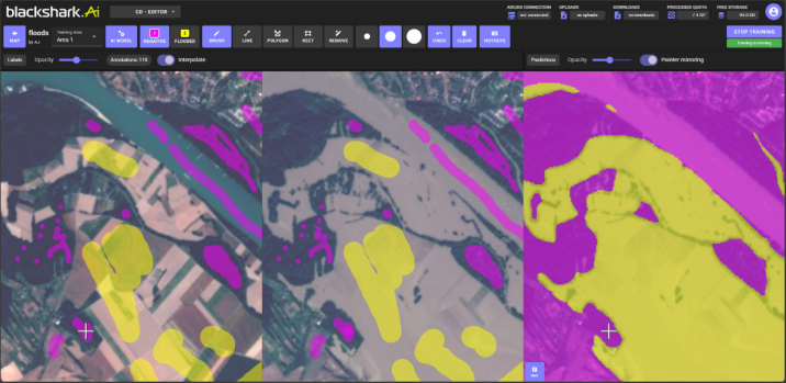
A key characteristic of the approach is the interactive labeling workflow, in which users generate training data directly on the imagery. Instead of requiring detailed and complete pixel-level annotations, the system allows the use of simple brush-based inputs. Users define relevant classes by marking representative examples, including both positive and negative instances. This
PostDisaster – XR Tools 867 reduces labeling effort while maintaining effective model performance and allows rapid adaptation to specific disaster events, geographic contexts, and seasonal variations in land cover.
In contrast to static pre-trained models, which often show limited transferability, this approach enables iterative model refinement based on user input and locally available data. This is particularly relevant in heterogeneous environments, where damage characteristics and background conditions can vary significantly.
The system further provides real-time feedback during model training, allowing users to immediately evaluate model outputs and iteratively improve detection results. This interactive loop supports time-sensitive analysis and enables continuous adjustment as new imagery becomes available during an ongoing disaster event.
The platform is implemented as a no-code environment, enabling users without machine learning expertise to define, train, and apply models via a graphical interface. Computational processing is supported by cloud- based GPU infrastructure, while local deployment options are available for scenarios with specific data or infrastructure requirements. The approach is applicable across multiple hazard types, including storms, floods, landslides, and wildfires. It supports data from different sensors and spatial resolutions. Medium-resolution satellite imagery enables rapid large-scale overview assessments, while higher-resolution aerial or drone data supports more detailed, object-level analysis of affected areas. By combining adaptive learning with change detection, the system enables efficient and consistent damage assessment while reducing analysis time compared to manual interpretation. The approach contributes to a systematic and scalable damage assessment, providing consistent and context-specific information to support evidence- based decision-making in post-disaster response and recovery.
Figure 1: Blackshark.ai platform displaying change detection mode with live labelling, applied to flood mapping in Austria based on sentinel-2 imagery (10 m resolution).
Drone-Based 3D Reconstruction of Disaster Areas and Interactive Operation Planning We researched and developed novel technologies for on-site data capture in disaster areas, subsequent 3D reconstruction, and interactive exploration for operation planning. The process begins with semi-autonomous drone flights that capture large numbers of images together with GPS coordinates. These data are then used to reconstruct a Gaussian Splatting 3D representation of the area (Kerbl et al., 2023). Our methods support fast digital exploration, rapid level-of-detail rendering, and color-coded change detection. Finally, the reconstructed data can be explored in VR for rescue planning. Each step is described in detail below.
Recording an area with a drone is a fast, inexpensive, and safe way to capture large outdoor environments, making it well suited for disaster scenarios. It is especially useful in dynamic situations where regions of interest are not known in advance and frequent recapturing is needed. We therefore developed an iterative reconstruction process that computes a 3D reconstruction from drone recordings of disaster areas and refines it as new data become available. For example, during active flooding, the system can first produce an overview reconstruction that helps response teams identify critical areas. These areas can then be re-captured in later flights, and the new recordings are used to refine the initial model into a more detailed reconstruction for mission planning. This significantly reduces the time from first flight to initial reconstruction compared to capturing the whole area in high detail at once, especially when the region of interest changes or is initially unknown.
Our approach builds on Gaussian Splatting (Kerbl et al., 2023) to enable photorealistic rendering and novel view synthesis. Because the input recordings capture the scene at different times, we track which Gaussians contribute to which time points. During optimization, previous reconstruction states are tested against new input images to determine whether a Gaussian remains valid for the latest data. The result is a combined reconstruction that represents the area across multiple times, highlights changed regions and preserves more detail than separate single-time reconstructions. Since change is encoded per Gaussian rather than per object, the method can capture variations in water levels, vegetation, and terrain. Figure 2 shows the result of our iterative reconstruction approach on two timesteps.
Figure 2: Reconstructions of an area scanned at two different times. Left and center show a true color render of the scene, before and after flooding, respectively. On the right, we highlight the changes between the two timesteps using our change visualization method.
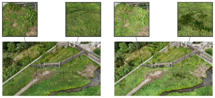
PostDisaster – XR Tools 869 In addition to iterative reconstruction, we developed a level-of-detail optimization and training approach (Siemers, 2026). To visualize large areas efficiently, the system manages multiple levels of detail internally and switches between them to maintain real-time performance while reducing aliasing. To lower computation time, optimization is performed progressively across resolutions, with each lower-resolution model initializing the next higher-resolution one. We also implement a selective rendering algorithm that chooses the appropriate level of detail based on primitive distance and camera parameters. Compared with the original Gaussian Splatting method, our approach reconstructs models faster and reduces aliasing in far views, though at the cost of additional memory to store all levels of detail simultaneously. An example reconstruction with both our method and the original baseline is presented in Figure 3.
The reconstructed 3D representation of the disaster area enables interactive visualization and operation planning for disaster resilience teams. We plan to use virtual reality for immersive exploration of the data, allowing users to annotate operation paths, obstacles, and target areas. This would let response units virtually inspect the affected area and plan actions as if they were on site, helping identify complications before deployment and improving operational efficiency. In addition, our change visualization supports rapid comparison between reconstruction steps to reveal the temporal evolution of the scene. This can help identify feasible rescue paths and prioritize urgent missions. Users could switch interactively between true-color and color-coded change visualization. Together, VR exploration and change detection can provide a powerful tool for rescue decision-making and operation planning.
Figure 3: Reconstruction of a scanned area: our method on the left, baseline on the right. In the zoom-ins, we can observe areas that are too bright in the baseline, and correctly reconstructed with enough detail by our method, as well as spurious dark patches in the grass visible only in the baseline.
MR-Based Labelling and Reconstruction of Infrastructures The MR-based tool for damage assessment is a distributed system comprising multiple components: (a) MR-glasses for labelling damages, (b) a 360-degree camera and a portable mini-PC to record the scene, (c) a server to reconstruct the recorded scene and (d) VR-glasses to view and edit the reconstructed scene and reported damages.
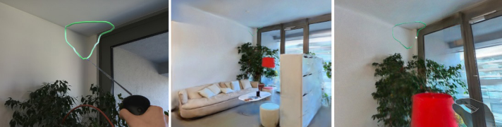
The user is equipped with the Magic Leap 2 (ML2) MR-glasses, an Insta 360 X5 camera and a Nvidia Jetson AGX Orin powered by a power bank. To start a recording session and enable labelling the user creates a new scene in the MR application, which triggers the recording on the Jetson connected to the 360-degree camera. For later alignment between the reconstructed environment and the marked damages (labels), the user first looks on a marker plate, that consists of four AprilTags (visual markers) placed inside the recording area. Since the relative position and orientation of the marker plate in relation to both the RGB camera of the Magic Leap 2 and the 360-degree camera can be determined, the labels and reconstructed area’s coordinates can be derived relative to the marker plate serving as origin. Thus, the labels can set at the correct location within the reconstructed virtual 3D-model of the recorded infrastructure. During the inspection the user can place virtual labels within the real environment to mark damages such as wall cracks and record audio notes for transparent documentation. Positional tracking is provided by the SLAM algorithm of the ML2.
After recording, the Jetson transmits the video captured by the Insta360 to a server, while the ML2 sends the labels, associated audio annotations, and tracking data of the glasses. Once the transfer is complete, the server begins processing the data. To create a digital representation of the scene, suitable frames are first extracted from the video. The camera operator is masked out of these images to remove them from the final reconstruction. These images, combined with the position data from the Magic Leap, are then processed using Structure from Motion (SfM) to generate an initial point cloud and determine the exact camera poses for every frame. This serves as the foundation for training the Gaussian Splats using the approach proposed in “Speedy-Splat” (Hanson et al., 2025), which result in a volumetric model that preserves fine details and thus enables an immersive, freely navigable visualization of the recorded environment.
After reconstruction the user can walk through the recorded scenery in a VR application developed for the Meta Quest 3. Users can load previously recorded scenes from the server. Since the employed Gaussian Splatting Unity viewer originally supported PLY file import only in the Unity Editor, we implemented a custom runtime import pipeline to enable loading reconstructed scenes during application use. Within the virtual environment, we enable inspection of reported damages, review voice notes, and edit or extend existing annotations. To support detailed inspection, the application also provides a toggleable visualization of the camera poses estimated during the OpenSfM-based reconstruction. These poses are shown as interactive spheres linked to the original reconstruction images. Selecting one of them
PostDisaster – XR Tools 871 opens an image-based viewpoint similar to Google Street View, allowing damages to be inspected directly in the recording. This is particularly valuable for documentation-oriented use cases, as it complements the reconstructed scene with original visual evidence.
Figure 4: Overview over the annotation and reconstruction process. The left image shows the user’s view through the Magic Leap 2 device with a set label. The center image shows the reconstructed scene within the Unity3D editor. The right image shows a first-person view through the VR glasses where the user sees the set labels in the reconstructed scene.
SUMMARY & OUTLOOK This work highlights the current status of the technical developments and the results of the user requirements phase. The current status of the system will be demonstrated and tested together with the end-users Geosphere and the Austrian Ministry of Defence in May 2026 at a military test site that consists of a reproduced village destroyed by an earthquake. All three technologies will be tested and evaluated based on technical feasibility, the applicability of the technologies, and the user interaction experience. The results of the user tests are then incorporated into further developments, and a final prototype is provided in December 2026, which will be again evaluated together with the end-users. Regarding the technical developments the main focus will be on enhancing and speeding up the 3D reconstruction and providing a more intuitive user experience.
ACKNOWLEDGMENT
The project PostDisaster is funded by the Austrian security research program KPASS of the Federal Ministry of Finance.
REFERENCES
Abraham, K., Abdelwahab, M., Abo-Zahhad, M., 2024. Classification and detection of natural disasters using machine learning and deep learning techniques: A review. Earth Sci. Inform. 17, 869–891. https://doi.org/10.1007/s12145-023-01205-2 Al Shafian, S., Hu, D., 2024. Integrating Machine Learning and Remote Sensing
in Disaster Management: A Decadal Review of Post-Disaster Building Damage Assessment. Buildings 14, 2344. https://doi.org/10.3390/buildings14082344
Braik, A.M., Koliou, M., 2024. Automated building damage assessment and largescale mapping by integrating satellite imagery, GIS, and deep learning. Comput.- Aided Civ. Infrastruct. Eng. 39, 2389–2404. https://doi.org/10.1111/mice.13197 Hanson, A., Tu, A., Lin, G., Singla, V., Zwicker, M., & Goldstein, T. (2025). Speedy-
splat: Fast 3D gaussian splatting with sparse pixels and sparse primitives. In Proceedings of the Computer Vision and Pattern Recognition Conference (pp. 21537–21546). Hu, D., Khalid, A., Xu, H., 2025. Interactive Digital Twin Platform for Enhancing Disaster Response and Coordination, in: 2025 IEEE 4th International Conference on Intelligent Reality (ICIR), pp. 1–4. https://doi.org/10.1109/ ICIR68135.2025.11361597 Kerbl, B., Kopanas, G., Leimkühler, T. & Drettakis, G., 2023. 3D Gaussian Splatting
for Real-Time Radiance Field Rendering. ACM Transactions on Graphics, 42(4). Khanal, S., Medasetti, U.S., Mashal, M., Savage, B., Khadka, R., 2022. Virtual and Augmented Reality in the Disaster Management Technology: A Literature Review of the Past 11 years. Front. Virtual Real. 3. https://doi.org/10.3389/ frvir.2022.843195 Krasniqi, E., Shehu, V., 2025. A Survey on Extended Reality in Disaster Management:
Integrating XR, IoT, and Machine Learning for Enhanced Situational Awareness, in: 2025 IEEE International Conference on Metrology for eXtended Reality, Artificial Intelligence and Neural Engineering (MetroXRAINE). pp. 547–552. https://doi.org/10.1109/MetroXRAINE66377.2025.11340049 Lee, H., Li, W., 2025. Geospatial Artificial Intelligence for Satellite-Based Flood Extent Mapping: Concepts, Advances, and Future Perspectives. https://doi. org/10.48550/arXiv.2504.02214 Manni, A., Oriti, D., Sanna, A., De Pace, F., Manuri, F., 2021. Snap2cad: 3D indoor
environment reconstruction for AR/VR applications using a smartphone device. Comput. Graph. 100, 116–124. https://doi.org/10.1016/j.cag.2021.07.014 Rao, A., Jung, J., Silva, V., Molinario, G., Yun, S.-H., 2023. Earthquake building damage detection based on synthetic-aperture-radar imagery and machine learning. Nat. Hazards Earth Syst. Sci. 23, 789–807. https://doi.org/10.5194/ nhess-23-789-2023 Siemers, O. 2026. Image Based Level-of-Detail Construction for Novel View
Synthesis. Master Thesis TU Wien Yize, W. (2026), gsplat-unity Github. Available at: https://github.com/wuyize25/ gsplat-unity (Accessed: 21 April 2026).
FIND THE COMPLETE VOLUME IN THE AHFE DIGITAL BOOKSTORE
Explore the complete digital volume
Human Systems Engineering and Design (IHSED2026): Future Trends and Applications
Read this individual research paper free through the original publisher, or explore the full digital proceedings book.