Lina Witzel, Sophy Chhong, Hans-Peter Hutter, Alireza Darvishy (2023). On-Site and Remote Crowdsourcing of Accessibility Data for People with Mobility Impairments: A Case Study in Zurich’s District 1. In: Human Interaction and Emerging Technologies (IHIET-AI 2023): Artificial Intelligence and Future Applications. AHFE Open Access, vol. 70, pp. 242–253. https://doi.org/10.54941/ahfe1002949
Collecting accurate accessibility data systematically for pathways is a time-consuming task that typically requires expert knowledge. However, it is a prerequisite to enable reliable and trustworthy accessible routing. The development of Capture & Go, a mobile application to report barriers for people with mobility impairments, facilitates the on-site collection of crowdsourced accessibility data. Several other mapping tools contain accessibility data, although they have not been developed explicitly for this purpose. In contrast to Capture & Go, they allow data collection to be performed remotely. Using quantitative and qualitative approaches, we analyzed several such applications and examined their efficiency in capturing barriers in a case study of District 1 in Zurich. The remotely collected data was compared to the data of the barriers captured on-site using Capture & Go. Overall, the remote tools were less efficient than Capture & Go in terms of effort, coverage, and accuracy of the barriers, as well as usability.
Finding a path from A to B is a challenge that everyone occasionally meets, if not regularly. While route planners, such as Google Maps (Google, 2022), exist to help find the right way, it is frustrating if one encounters an unexpe- cted obstacle that hinders the passage. People with mobility impairments, i.e., wheelchair users, often face this challenge. Standard route planners cannot ensure users that a calculated route is accessible. Hence, there is a need for further development in the area of accessible routing (Darvishy et al., 2022). The first step in achieving reliable accessible routing is to gather information about existing barriers on a route. In 2022, Capture & Go was developed to enable non-experts to easily report barriers for people with mobility impair- ments on-site (InIT, 2022). Users can efficiently capture barriers with the application when encountering them on their way. By crowdsourcing the data collection, the barriers are supposed to be up-to-date and comprehensive.
On-Site and Remote Crowdsourcing of Accessibility Data 243
An alleged disadvantage of Capture & Go is the requirement to be on- site to capture barriers. For the city of Zurich, a number of other remote tools can be used to gather accessibility data in an alternative way, including government-generated maps, commercial products and open-source maps. Although these tools are not specifically developed for the purpose of colle- cting accessibility data, they can provide the means to extract information about potential barriers. This empirical study analyzes the effectiveness of these remote tools for the collection of accessibility data, and compares them to the on-site data collection approach of Capture & Go in a case study for District 1 in Zurich (Switzerland).
RELATED WORK
The environmental challenges of wayfinding for people with mobility impair- ments are described in research that evaluates the frequency and the various types of barriers that wheelchair users encounter daily (Meyers et al., 2002). Accessible routing aims to find the most suitable way for a person with a mobility impairment, taking into account any barriers on the way. To com- pute such routes, all potential barriers must be captured beforehand. Projects such as StreetComplete (Zwick, 2022) or GoMap! (Cogswell, 2020) facilitate the tagging of data points in OpenStreetMap; however, they are not suitable to cover all of the many accessibility problems that exist.
Recent research has demonstrated the need for personalization of accessi- bility routing, with the necessity of collecting specific accessibility data first (Darvishy et al., 2022). Accordingly, some projects focus on the remote labe- ling of accessibility problems, for example, Project Sidewalk (Saha et al., 2019), where users can identify barriers using Google StreetView images. To capture barriers when encountering them on-site, solutions such as Acces- sComplete (Stoll, 2020) and Capture & Go (InIT, 2022) have been developed. The projects AccessMap (Bolten, 2019) and path-Nav (Sinagra, 2019) even go a step further and enable the calculation of accessible routes. Both of these projects allow for route customization based on the individual needs of the users. Such projects are constrained by the limited availability of open- source accessibility data and the resulting routes that are not truly accessible (Darvishy et al., 2022).
METHODOLOGY
To analyze the collection of new barriers and the verification of already repor- ted barriers, two types of methods were carried out. For both approaches, the data collected by Capture & Go served as the ground truth for analyzing the performance of the remote tools.
For the first method, the data was collected on-site with Capture & Go in Zurich’s District 1, followed by the verification of a sample of barriers by the remote tools. Each tool was used to identify the previously collected barriers and verify the measurements. For the second method, the order was reversed; a random street, that was previously unfamiliar to the authors, was chosen outside of District 1. The remote tools were consulted to see how
many barriers were found on the street with each tool. Then, these barriers were verified on-site using Capture & Go. Additional barriers not found in any of the remote tools were also recorded in Capture & Go.
Performance was evaluated by calculating the finding rate, measurability rate, and accuracy of the barriers. Only found barriers accounted for the rate of measurability. Their relative accuracy to the ground truth (collected by Capture & Go) was determined using relative errors. The calculations differ for each type of barriers, as they vary in the measurement data. For gates, bollards, others, cycle barriers, blocks and planters, the accuracy was deter- mined by the measured passage difference between barriers. The accuracy in kerbs was calculated from the height difference related to the height of the ground truth, whereas cross drains used the width differences. Stairs have multiple relative error results: one for the number of steps and one for the average height of a step. The mean of both error results was calculated to express the accuracy of the stair measurements. For problematic ways, accu- racy was calculated from the difference in degree (for cross or running slopes) or the match of the type of surface.
The second method compares the coverage and falsely determined barriers (false positives) of the remote tools. The percentage of ground truth barriers that have been found by the remote tools account for the coverage. On the other hand, barriers found to be inaccessible by the remote tools, but not Capture & Go, make up the false positive rate.
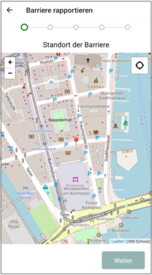
Capture & Go In 2022, the InIT Institute of Applied Information Technology (ZHAW School of Engineering; 2022) developed the application “Capture & Go”. Capture & Go enables users to report and view barriers for people with mobi- lity impairments. Users can select the location of a barrier, indicate the type of barrier, and add further information, for example, a picture or description (Fig. 1). After its creation and review, the barrier is added to OpenStreetMap (OSM, 2022a), and becomes visible to other users. Ten different types of barriers can be captured: gates, blockages, cycle barriers, bollards, stairs, planters, kerbs, problematic ways (i.e., surfaces and slopes), cross drains, and “other” (e.g., construction sites). Each barrier type requires different types of information to be entered by the user, for example, step height and step count for the type “stairs”.
The on-site collection of barriers was performed using a smartphone having Capture & Go and an incline measuring app installed. A folding rule- r/measuring tape, a wooden beam with length ticks, a small kerb measuring wood piece, a city map and a pen were used during data collection. Infor- mation, such as start time of barrier recording and time when finished, was automatically added to a barrier by the smartphone app. In addition to noting and measuring a barrier, at least one picture was taken for each recorded bar- rier which turned out to be helpful for remote verification. For our analysis, all captured barriers for District 1 were extracted from the database in order to perform the calculations for coverage and accuracy. The verification of barriers of the chosen street followed the same procedure.
On-Site and Remote Crowdsourcing of Accessibility Data 245
Figure 1: The screen for locating the barrier and the screen to enter details about a barrier in Capture & Go. (InIT, 2022).
OpenStreetMap With the goal of providing free geographic data, OpenStreetMap is an initia- tive based on crowdsourcing (OSM, 2022b). The data of OSM is structured into data points (nodes, ways, and relations) which can be tagged and labe- led with different values/attributes that describe it (OSM, 2022c). The tags, values, and any other information regarding the data points are documen- ted in the corresponding Wiki pages (OSM, 2022c). OpenStreetMap can be accessed in the browser and offers different tools such as zooming, searching for a specific location, and changing the map layer (OSM, 2022a). As pre- viously mentioned, the goal of Capture & Go is to add accessibility data to OpenStreetMap. Nonetheless, some of the data entered by OSM users alre- ady provide information about possible barriers. For example, a node tagged as a kerb with the associated value “raised”, declares that the kerb is higher than 3 cm and therefore not accessible for the average wheelchair user (OSM, 2022c). From the collection of barriers with Capture & Go, a sample that covers all barrier types except bollards was verified (as bollards cannot be found on OSM). The Capture & Go data provides exact OSM coordinates. Once the coordinates had been entered in OSM, the query feature was used to highlight paths/nodes in the radius of a chosen point. The barrier was determined based on the selection. If it existed, the entry was compared to its counterpart in Capture & Go.
For the barrier collection on an unfamiliar street, the chosen street was “traversed” on OSM by dragging the map. The query tool was used to high- light possible points of interest. If a barrier was found, its information was manually added to the data. Time-related information, such as time to find a barrier and time to report the barrier, was measured by using a stopwatch and manually documented.
Infra3D A more immersive approach is the tool Infra3D developed by iNovitas (2022c). By offering a geo-referenced 3D image database, the user can navi- gate through high-resolution three-dimensional imagery. Infra3D has the option of choosing a view on a given path, that is, either a road, tram track, or footpath. Furthermore, a 360
view is provided from the center of the vehicle; the front view is defined by the direction of travel (0
), the right rear view by approximately 120
, and the left rear view by approximately 240
. The contrast slider and zoom function allow for a better sight of a particular barrier. Furthermore, the Infra3D Web Client (iNovitas AG, 2022a) provides several measurement and analysis tools, for example, to measure distances or areas (iNovitas AG, 2022b).
Similar to the OSM verification, coordinates can be directly entered into Infra3D, although its accuracy is not always guaranteed. For precise location- finding, OSM was used to determine the exact location of the barrier. The location was compared and adjusted on the Infra3D map, which uses OSM as the underlying structure. Different angles were used to further determine the exact location of the barrier. In addition, images captured with Capture & Go were sometimes used to verify the barrier with the 3D image. With the exception of barriers located at inaccessible locations for the Infra3D car, all barrier types could possibly be found. Measurements were carried out in a zoomed-in view of the barrier. Using the distance measurement tool, two points were fixated and the distance between them was calculated. For the incline measurements, additional options of viewing the horizontal and vertical distance were used to calculate the incline manually.
For the remote collection, the street was navigated with arrows on the user interface or paths on the map to find potential new barriers. Similar to OSM, time-related data was manually measured with a stopwatch.
Zürich Virtuell The city of Zurich provides a “digital twin” of Zurich - the interactive map Zürich Virtuell (Stadt Zürich, 2022b). Similar to Infra3D, they offer a 3D model of the city and measurement tools. Although Zürich Virtuell does not provide 3D imagery, objects such as houses and trees are placed as true- to-scale models (Stadt Zürich, 2022a). Furthermore, the map includes an accurate digital elevation model and the data is part of the Open Government Data, which can be used for free (Stadt Zürich, 2022c).
Compared with OSM and Infra3D, Zürich Virtuell does not rely on coor- dinates for navigation; instead, street names can be entered in the search bar. Because the ground truth data only supplies coordinates for the exact loca- tion, the streets of the barriers to be verified were determined with OSM and entered in Zürich Virtuell. Dragging and turning the map allowed for a suita- ble view of the street. The measuring process was similar to that in Infra3D, fixing two points on the map to determine the inclined distance, as well as the vertical and horizontal distance. The latter information was used to deter- mine the incline and a separate stopwatch handled the time data. In addition to problematic ways, planters are the only other barrier type determinable by
On-Site and Remote Crowdsourcing of Accessibility Data 247
the remote tool. Planters are shown on the map as virtual trees with its data attached.
The remote collection of the chosen street was carried out by traversing the street by dragging and turning the map and measuring it as explained in the previous paragraph. No additional navigation options are available in Zürich Virtuell.
Baustellenliste Zürich The main problem with the above-mentioned tools is that they are snapshots of the city. Temporary barriers are unlikely to be found on these maps. To this end, the list of current construction sites in Zurich can be used for the analysis of temporary barriers (Stadt Zürich, 2022a). The construction sites are sorted by street names with the duration of the construction work indicated. In addition, all construction sites can be viewed on a map (Stadt Zürich, 2022b) in order to see which part of the street is blocked.
As the German name suggests (Baustellenliste means “list of construction sites”), the remote tool may be used to verify the presence of construction sites, which are listed in Capture & Go as barrier type “other”. The GPS coordinates used by Capture & Go could not be directly searched for in the official Baustellenliste of the City of Zurich; as with Zürich Virtuell, only street names may be used to identify a barrier. For this reason, the street name where the given barrier was located was first identified through OSM; then, it could be compared to the list in the Baustellenliste or entered into the search function of the map.
For the collection of barriers on an unfamiliar road, the name of the sele- cted road was checked against the list of street names in the construction list, and then visually identified on the map. Alternatively, construction sites could be directly looked up on the map.
RESULTS
On-Site Collection & Remote Verification After removing invalid time entries (entries with a reporting time of less than 3 seconds), Capture & Go shows 1154 barriers reported over District 1. As seen in Table 1, barriers of type “problematic way” and “stair” are predomi- nant, followed by cross drains and kerbs. At the lower end, only a handful of gates, bollards, cycle barriers, and planters have been reported. The ove- rall average time to report a barrier was 32 seconds. The analysis showed a slightly higher number for the average median time of 45 seconds. The num- bers shown in Table 1 do not account for the time needed to find the barrier (i.e., walking and spotting time), and only represent the time used to deter- mine and report details of a barrier and to take a picture. On-site experience has shown, however, that spotting a barrier is very fast and can normally be performed more or less in real time while walking.
In the subsequent analysis, the data has been cleaned of outliers (upper 10%) resulting in 1075 remaining barriers for the verification. After that, for
OSM Infra3D Barrier Barriers Sample Barriers Barriers Average Barriers Barriers Average type total size found measurable relative error found measurable relative error
each category of barrier, a random sample was obtained. The sample con- sisted of either 10% of the data or at least 30 samples, if the data for the category was not large enough. The exceptions were barriers of type gate, bollard, other, cycle barrier, and planter, where all the data was used because of the few reported barriers. This sample data was then verified using the remote tools (see Table 2 and Table 3). To compare the accuracy of the indi- vidual measurements, the barrier types “stair” and “problematic ways” are split up by their kind of measurement.
It was found that OSM provided little comparable data: only 62 (29.81%) of the barriers reported in Capture & Go could be verified in OSM. Neverth- eless, all sample gate and cross drain barriers could be found, although OSM
On-Site and Remote Crowdsourcing of Accessibility Data 249
Table 3. Verification results (2/2).
Table available in the original PDF paper.
Zürich Virtuell Baustellenliste Zürich Barrier Barriers Sample Barriers Barriers Average Barriers Barriers Average type total size found measurable relative error found measurable relative error
did not include their width measurements. However, cycle barriers and plan- ters could not be verified by OSM, as they were not present in the OSM data. Overall, with OSM we were able to find approximately half of the sample barriers, with measurements for 62 of the found 126 barriers (49.21%) and an error rate of 21.55%.
Infra3D showed a different picture, as we were able to detect 148 of the 208 sample barriers (71.15%) and measure 130 of them (87.84%). Noneth- eless, the overall error rate (29.66%) was similar to that of OSM. For almost all barrier types, if a barrier was found, it could also be measured most of the time. However, not all streets of District 1 were covered in Infra3D, so even if a barrier could be seen in the imagery, we were not always able to view it well enough in order to measure it. One such example is the barrier type “stair”, where only 9 of 22 (40.91%) of the sample barriers could be measured.
Zürich Virtuell produced high detection results for the two barrier types “planter” and “problematic ways”, by finding almost all sample barriers. Nonetheless, across all barrier types, only 56 of the 208 barriers (26.92%) were found. The overall error rate was very high at 104.28%, due to the inaccurate measurement of the single planter. The average error rate for problematic ways (running and cross slopes) was 33.77%.
Finally, the list of construction sites for the City of Zurich was not use- ful for finding any construction barriers, as none of the construction sites reported with Capture & Go could be found on the list.
Remote Collection & On-Site Verification The selected road outside of District 1 was first traversed virtually using all remote tools, and subsequently in person with Capture & Go, resulting in a total of 120 barriers. Tables 4 and 5 show the results for each of the tools. There were 26 barriers detected by OSM, 6 by Zürich Virtuell, 27 by Infra3D,
Table 4. Remote collection results (1/2).
Table available in the original PDF paper.
OSM Zürich Virtuell Barrier Number of Mean reporting Number of Mean time type barriers time per barrier barriers per barrier
and 61 by Capture & Go. No barriers were encountered in the list of constru- ction sites for Zurich; therefore, we excluded this tool from further analysis. Problematic ways and cross drains were by far the most commonly found types of barriers. No cycle barriers nor bollards were encountered with any of the tools. With Capture & Go, the mean reporting time needed was lowest at 19 seconds, followed by OSM at 31 seconds. At the other end was Zürich Virtuell, taking almost 2 minutes to calculate barrier details on average.
Table 6 shows the percentage of barriers covered by the remote tools. Of the 61 barriers reported with Capture & Go, only 17 barriers (27.87%) were found in OSM, and only 19 (31.15%) were found in Infra3D. With Zürich Virtuell, 14 of the barriers (22.95%) were identified. By combining all remote tools, 33 barriers were identified, accounting for a total coverage of 54.10%. In OSM, 11 of 26 barriers could not be found on-site (false positives). With Zürich Virtuell, 3 barriers were falsely reported, and with Infra3D, 10 false positives were found, resulting in 23 falsely determined (unique) barriers for the combination of all tools.
In Table 7, the coverage of each tool can be seen; split into the respective barrier types. Overall, the combination of all remote tools was successful in finding all stairs and all cross drains but only 16 of 37 (43.24%) of the problematic ways. Gates, kerbs, and barriers of type “other” were not found by any remote tool.
CONCLUSION AND FUTURE WORK In conclusion, the remote tools were not appropriate replacements for Capture & Go. Regarding coverage of (types of) barriers, Capture & Go remains the most suitable application, followed by Infra3D. Infra3D provi- des an environment that makes remote data collection more similar to on-site collection, but is not as effective as Capture & Go. Even though some types of barriers can be measured quite well remotely, without having verified them on-site, the measurements would not be sufficiently accurate. The exceptions
On-Site and Remote Crowdsourcing of Accessibility Data 251
Table 5. Remote collection results (2/2).
Table available in the original PDF paper.
Infra3D Capture & Go Barrier Number of Mean reporting Number of Mean reporting type barriers time per barrier barriers time per barrier
are tram tracks, which could be directly translated from OSM to cross drains with a universal width of 4 cm. With regard to the effectiveness of the repor- ting and verification of barriers of all types, on-site data collection cannot be fully replaced by remote data collection (yet).
The results have shown that capturing barriers on-site with apps such as Capture & Go are feasible within a reasonable time and with reasonable effort, at least for smaller compact cities like Zurich. To achieve sufficient coverage and accuracy of accessibility data, systematic on-site data colle- ction (e.g., crowdsourcing) is inevitable. Although capturing barriers with Capture & Go is easy and intuitive, instructions on how to capture barriers are important in order to obtain consistent barrier data. Providing thresh- olds for measurements could help users, especially those who are not familiar with mobility impairments, to identify barriers. Moreover, the development of algorithms for the automatic extraction of accessibility data could improve the efficiency of remotely collecting accessibility data.
ACKNOWLEDGMENT
We would like to thank Prof. Elaine M. Huang and Roland Mosimann for their support. Finally, we want to thank our friends, family, and François Loriol for their interest in the topic and for increasing the awareness of accessibility problems.
REFERENCES
Bolten, N., Caspi, A. (2019) “Accessmap website demonstration: Individualized, accessible pedestrian trip planning at scale”, The 21st International ACM SIGA- CCESS Conference on Computers and Accessibility, ASSETS, 2019, Pittsburgh, PA, USA, October. pp. 676–678. https://doi.org/10.1145/3308561.3354598 Cogswell, B. (2020) GoMap! Available at: https://github.com/bryceco/GoMap
(Accessed: 9 October 2022). Darvishy, A., Hutter, H. P., Mosimann, R. (2022) “Towards personalized accessible routing for people with mobility impairments”, International Conference on Computers Helping People with Special Needs: 18th International Conference, ICCHP-AAATE, 2022, Lecco, Italy, July 11–15. Cham: Springer International Publishing, pp. 221–220. Google (2022) Google Maps. Available at: https://www.google.com/maps (Accessed:
3 October 2022). InIT Institute of Applied Information Technology (2022) Capture & Go. Available at: https://play.google.com/store/apps/details?id=ch.zhaw.init.captureandgo2 (Accessed: 11 October 2022) iNovitas AG (2022a) Infra3D. Available at: https://www.infra3d.ch/ (Accessed: 5
October 2022) iNovitas AG (2022b) Infra3D - Manual. Available at: https://www.infra3d.ch/docs/c lient/3.14.0/en/home.md (Accessed: 5 October 2022) iNovitas AG (2022c) Infra3D - Service. Available at: https://www.inovitas.ch/en/pro
ducts/overview/ (Accessed: 5 October 2022) Meyers, A. R., Anderson, J. J., Miller, D. R., Shipp, K., Hoenig, H. (2002) “Barriers, facilitators, and access for wheelchair users: substantive and methodologic lessons
On-Site and Remote Crowdsourcing of Accessibility Data 253
from a pilot study of environmental effects”, Social Science & Medicine, 55(8), pp. 1435–1446. doi: https://doi.org/10.1016/s0277-9536(01)00269-6 OSM (2022a) OpenStreetMap. Available at: https://www.openstreetmap.org/ (Accessed: 1 October 2022) OSM (2022b) OpenStreetMap – About. Available at: https://wiki.osmfoundation.o rg/wiki/About (Accessed: 3 October 2022) OSM (2022c) OpenStreetMap - Wiki. Available at: https://wiki.openstreetmap.org
/wiki/Main_Page (Accessed: 3 October 2022) Saha, M., Saugstad, M., Maddali, H. T., Zeng, A., Holland, R., Bower, S., Dash, A., Chen, S., Li, A., Hara, K., et al. (2019) “Project sidewalk: A web-based crowdsourcing tool for collecting sidewalk accessibility data at scale”, Procee- dings of the 2019 CHI Conference on Human Factors in Computing Systems, CHI, 2019, Glasgow, Scotland UK, May. pp. 1–14. doi: https://doi.org/10.1145/ 3290605.3300292 Sinagra, E. (2019) Development of pathNav: A Pedestrian Navigation Tool that
Utilizes Smart Data for Improved Accessibility and Walkability. TRANSIT-IDEA Program Project Final Report, Issue 87. Available at: https://www.trb.org/Main/B lurbs/179902.aspx (Accessed at: 7 March 2023) Stadt Zürich (2022a) Baustellen List. Available at: https://www.stadt-zuerich.ch/ted /de/index/taz/bauen/baustellenliste_a-z.html (Accessed: 5 October 2022) Stadt Zürich (2022b) Baustellen Map. Available at: https://www.maps.stadt-z
uerich.ch/zueriplan3/Stadtplan.aspx#route_visible=true&basemap=Stadtpla n&map=&scale=16000&xkoord=2683305.3500126875&ykoord=1248138. 7598833835&lang=&layer=Baustelle%3A%3A47&window=&selectedObje ct=&selectedLayer=Baustelle&toggleScreen=1&legacyUrlState=&drawings= (Accessed: 5 October 2022) Stadt Zürich (2022c) Zürich Virtuell. Available at: https://www.stadt-zuerich.ch/ted /de/index/geoz/Zuerich_Virtuell.html (Accessed: 5 October 2022) Stadt Zürich (2022d) Zürich Virtuell 3D Stadtmodell. Available at: https://ww
w.stadt-zuerich.ch/ted/de/index/geoz/geodaten_u_plaene/3d_stadtmodell.html (Accessed: 5 October 2022) Stadt Zürich (2022e) Zürich Virtuell Map. Available at: https://web.stzh.ch/appl/3d /zuerichvirtuell/ (Accessed: 5 October 2022) Stoll, S. (2020) AccessComplete - A Crowdsourcing App for Wheelchair Related
Accessibility Data on OpenStreetMap. Master thesis. University of Zurich. Zwick, T. (2022) StreetComplete. Available at: https://github.com/streetcomplete/St reetComplete/ (Accessed: 9 October 2022).
LISTED IN THE AHFE DIGITAL BOOKSTORE CATALOGUE
Explore the complete digital volume
Human Interaction and Emerging Technologies (IHIET-AI 2023): Artificial Intelligence and Future Applications
Read this individual research paper free through the original publisher, or explore the full digital proceedings book.
ISBN 978-1-958651-46-9
Explore this ISBN in the AHFE Bookstore ↗Listed in the July 2026 bookstore catalogue; search by ISBN to confirm current availability · Digital book purchase optional