Jennifer Palilonis (2024). GoodMaps: Assessing an Indoor Navigation App Built on Camera-based Positioning. In: Human Interaction and Emerging Technologies (IHIET 2024). AHFE Open Access, vol. 157, pp. 544–555. https://doi.org/10.54941/ahfe1005514
This paper presents GoodMaps, an AI-driven indoor navigation tool, and chronicles findings from formative focus groups and user acceptance testing with a diverse group of participants. GoodMaps is built on camera-based positioning integrated with a smartphone app that provides turn-by-turn navigation indoors. Originally designed to support blind and low-vision users in independent indoor navigation, GoodMaps was redesigned in 2023 to help all people navigate safely and efficiently with dynamic routing instructions, orientation aids, visual maps, augmented reality, and landmark recognition. This paper shares key challenges, tensions, and opportunities in designing assistive tools for differently-abled users and app-based navigation solutions.
Being able to travel independently is critical to maintaining quality of life and participation in a community (Lindsay & Lamptey, 2019). However, doing so can be challenging for individuals who face physical or neurological disabilities. Of course, the outdoor world is effectively mapped, with apps like Google Maps, Apple Maps, MapQuest, and Waze providing accessible navigation support. A variety of techniques and devices also provide navigation support for indoor spaces. For example, Bluetooth trilateration is used to calculate someone’s position and relies on a known distance between two or three reference points marked by installed beacons. Despite efforts to provide indoor navigation similar in ease of use and accuracy to Apple and Google Maps, these efforts are in their infancy.
Outdoor navigation is governed by GPS, which is relatively inaccurate and/or difficult to consistently implement indoors. GoodMaps, an AI-driven indoor navigation app built on a camera-based positioning system (CPS), implements geo-referenced images to determine a user’s position. CPS can locate where someone is in a room within one meter of accuracy, a substantial improvement over GPS (10 meters outdoors), Bluetooth trilateration (five meters), and other approaches. To date, GoodMaps has mapped just over 23 million square feet of indoor space around the world, with live mapped square footage at just under 19 million ft2. U.S. availability includes train
GoodMaps: Assessing an Indoor Navigation App Built on Camera-Based Positioning 545
stations, libraries, shopping malls, and sporting arenas, with that scope broadening. Three major airports in the U.S. are also mapped– Portland, OR, Louisville, KY, and Westchester, NY – which collectively serve about two million passengers per month. Outside the U.S., the app is available throughout the U.K. – including in large swaths of the country-wide rail network – in Canada, Continental Europe, and Central and South America, where users can access retail spaces, transit hubs, and corporate buildings. Originally designed to support blind and low-vision (BLV) users, GoodMaps was redesigned in 2023 to support indoor wayfinding for all by providing dynamic routing instructions, orientation aids, and landmark recognition.
In 2023, two focus groups and four rounds of User Acceptance Testing (UAT) were conducted with 100 participants to collect feedback about app design, functionality, and overall user experience. Focus groups were remote (conducted via Zoom) with 53 users. The first focus group included sighted participants who were given control of an interactive prototype and asked to provide feedback about interface design and feature functionality. About one- half of those participants identified as: anxious/nervous travellers, hearing impaired, neurodiverse, and/or wheelchair user. The second focus group included BLV users who provided insights about challenges they face with indoor navigation. A beta app was developed, and UATs were conducted with 47 individuals who are BLV (including guide dog users and white cane users), hearing impaired, neurodiverse, and mobility impaired, as well as users with no reported disability. These UATs were held at a museum in Louisville and were designed to collect feedback about the live routing experience, app functionality, and app design. All UATs resulted in iterative improvements to the user interface, user experience, and system functionality. Data from these sessions helped identify instances in which:
users struggled to understand the nature and/or functionality of a feature;
design was confusing, unattractive, and/or detrimental to user experience.
REVIEW OF BACKGROUND Indoor navigation is a technology-supported activity in which users can travel to specific indoor locations. Indoor navigation typically involves five key components: 1) generating navigation models from 3D building models or indoor maps; 2) identifying a user’s location in a building through indoor positioning; 3) path-planning to align building models with location coordinates, spatial semantics, and room properties; 4) turn-by-turn navigation instructions based on routing visualizations; and 5) smartphone apps/other devices to support spatial cognition, wayfinding, and orientation (Liu, Li, Zlatanova & Oosterom, 2021).
State-of-the-Art in Indoor Navigation Accessible GPS devices introduced in the past 15 years, as well as development of smartphone and navigation applications, has enabled people
546 Palilonis
to easily navigate to desired destinations. However, GPS-enabled apps and devices are limited to outdoor navigation, rendering them ineffective for indoor wayfinding. Most assistive technologies developed to help people navigate indoor spaces require renovations to the space or installation of custom proprietary devices (Faria et al., 2010; Nakajima & Haruyama, 2012; Ahmetovic et al., 2016).
By 2024, more than 7 billion people worldwide reported owning a smartphone. Likewise, the use of assistive apps to help individuals with disabilities reach heightened levels of autonomy is on the rise (Abraham et al., 2022). Studies have shown that individuals with disabilities frequently use apps designed to help them accomplish daily activities (Griffin-Shirley et al., 2017). Several solutions exist for indoor mapping. However, there are a variety of approaches to the complex nature of dynamic wayfinding. Table 1 describes popular indoor wayfinding apps and includes how each differs from GoodMaps. A few additional solutions have existed, including Clew (users retrace a previously recorded route); Soundscape, a Microsoft solution sunsetted in 2022; and Nearby Explorer, sunsetted in 2019.
Table 1. State-of-the-art in most commonly used indoor navigation apps.
Table available in the original PDF paper.
App Name & Description Differentiation
SDK approach requires Wi-Fi
Hyper: Indoor navigation powered by Augmented Reality sensors and WiFi
Requires installation of Bluetooth beacons for navigation
No venue management system Lazarillo: App guides users through buildings with real-time voice messages
No built-in navigation support
Android-only
Lazarus: App provides navigation assistance through geolocation, voice recognition, and device camera
No audio/voice instructions
Requires installation of Bluetooth beacons for navigation
Pointr: AI-powered, beacon-based navigation and mapping platform; provides blue-dot location and visual map with routing information
Requires installation of Bluetooth beacons for navigation
No support for people with disabilities RightHear: App + portal for integration of audio descriptions of a location
Does not require any external signals
User must download venue maps
Waymap: Indoor navigation app provides turn-by-turn navigation support
Independence, Self Determination, and Assistive Technology Access to and use of assistive technology has had a positive psychosocial effect on feelings of competence, adaptability, and self-esteem among users with disabilities (McNicholl, Desmond & Gallagher, 2023). Studies have also demonstrated that when students with disabilities use assistive devices and apps in educational settings, it promotes heightened feelings of academic
GoodMaps: Assessing an Indoor Navigation App Built on Camera-Based Positioning 547
self-efficacy (Depountis, Okungu & Molloy-Daugherty, 2019). Likewise, assistive technology has been found to “promote participation and inclusion in society, and support access to health, social services, education, work and other important life experiences for persons with disabilities, older people, and those with chronic conditions” (Smith, et al., 2024). Recently, organizations like WHO and UNICEF have called for improved access to assistive tech globally, asserting that it is critical to the achievement of differently abled people (UNICEF, 2022). When it comes to navigation and wayfinding, inaccessible spaces can have a profoundly negative affect on quality-of-life, health and safety, independence, and social participation among differently abled individuals (Kapsalis, Jaeger & Hale, 2024). Specifically, mobility, vision, and neurological impairments may lead to susbstantial disruptions in the ability to freely and easily move between places.
METHODOLOGY
User Acceptance Testing (UAT) is a user-centered phase of development in which a digital product is tested in the real world by its intended audience. The GoodMaps app was developed through multi-phased design and development process that included two focus groups and four rounds of UAT conducted over the course of a year as part of an iterative process. Early research informed the vision, design, and development of the initial feature set. Subsequent UATs informed design and functionality and led to the identification of features for future development.
GoodMaps First launched in September 2020, GoodMaps is a smartphone app for iOS and Android devices that provides turn-by-turn navigation for indoor spaces. The app is designed to help people navigate safely and efficiently with dynamic routing instructions, orientation aids, and landmark recognition. To create an accessible building map, a GoodMaps technician scans a facility with a LiDAR camera that captures 360-degree images, measurements, and video. Second, an accurate, detailed map is created from the scan data. Points of interest–like restrooms, offices, dining, fire extinguishers, exits, etc.–are tagged in GoodMaps Studio, which processes and hosts all map data. Studio generates three map views: a 2D floorplan, a LiDAR point cloud, and a 3D model. Third, building supervisors can add location names in Studio, update points of interest, and set up access permissions for the map. Fourth, the building map is published to the GoodMaps navigation app. Once a map is published, app users can navigate indoor spaces using the app along with voice, tactile (haptic vibrations), or text prompts to find their desired destinations. Buildings mapped with this technology are explorable via the app, which includes step-by-step navigation to selected destinations. CPS determines a users’ position in a building, and the app offers information about indoor points of interest. The app relies on visually distinct surroundings, such as patterned carpets, ceiling panels, and art to provide accurate location information.
548 Palilonis
Procedures & Participants Early iterations of the GoodMaps app (formerly called Explore) were designed for use by individuals who are blind and/or visually impaired. In 2023, the app was redesigned to extend its reach to all people, with special attention to features for a wide range of ability. Table 2 outlines the nature of three phases of user-centered research and development for this redesign:
1. Discovery Research included two focus groups designed to understand sighted users’ indoor navigation needs and to identify key features. 2. Formative Research included two sets of remote UAT interviews during which sighted participants provided feedback on an app prototype. 3. Summative Research included UATs with diverse users at a museum.
Table 2. Research participants and procedures.
Table available in the original PDF paper.
Discovery Phase Focus Group 1 3 remote sessions, 9–10 users each N = 28 – No disability: 15; Neurodiverse: 8; Wheelchair: 5 Focus Group 2 2 remote sessions, 12–13 users each N = 25 – Blind: 15; Low vision: 10 UAT 1 Remote interactive prototype testing N = 13 – No disability: 7; Neurodiverse: 3; Wheelchair: 2 UAT 2 Remote interactive prototype testing N = 12 – No disability: 5; Neurodiverse: 3; Wheelchair: 3
Summative Phase: Sessions required each participant to provide feedback about specific features after completing tasks while using the app.
UAT 3: In-person task-based testing N = 10 – No disability: 6; Neurodiverse: 4 UAT 4: In-person task-based testing N = 12 – Blind: 8; Low vision: 4
Data Analysis Each research session generated qualitative interview data, and task-based UATs generated observational and interview data. Although results from these sessions does not yield statistically significant results, interview and observational data analysis allows for the abstraction of raw data into more general insights. Because qualitative data is inherently unstructured, interview responses were assigned thematic tags to structure and help synthesize the data. Observational notes collected during UATs helped illuminate common user behaviors while using the app to travel routes in real-world settings. Thus, transcripts from semi-structured interviews and observational notes were coded to illuminate key themes related to participants’ understanding of app functionality, user experience, and design preferences. Each unit of analysis–defined as a full sentence or sentence fragment that represented a complete thought–was assigned a code to represent a summative, salient, and/or essence-capturing attribute (Saldana, 2009).
GoodMaps: Assessing an Indoor Navigation App Built on Camera-Based Positioning 549
RESULTS
After coding all individual responses and observational notes, common user experience themes and recommendations for improvement emerged based on cross-participant commonalities.
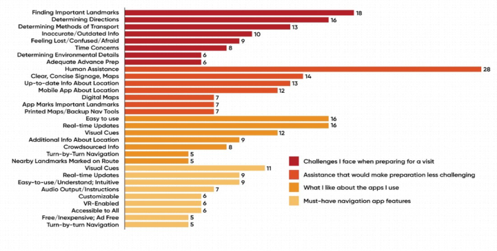
DISCOVERY PHASE: FOCUS GROUPS The first round of focus groups explored needs and perspectives of sighted (no disability), wheelchair, and neurodiverse users. Figure 1 illustrates key themes that emerged from focus groups related to challenges users face when preparing to visit a new venue, assistance that would make preparation less challenging, features they appreciate in frequently used apps, and must-have navigation app features.
Figure 1: Key themes from sighted user focus groups.
A second focus group included BLV users and was designed to elicit feedback about challenges faced when visiting unfamiliar destinations, desired assistive tools, and features that motivate use of navigation apps. Participants reported using a wide range of apps for navigation. They also noted that most of these apps were built for the sighted world, with BLV users an afterthought (at best), making them cumbersome to use. Several additional themes surfaced:
Traditional navigation apps don’t provide enough information about a BLV user’s surroundings. However, too much information delivered via screen readers or text-to-speech may result in information overload.
Interface design is often not optimized for screen reader interaction, making apps difficult to navigate for BLV users.
BLV users cannot confirm they are in the “right” place by sight, so concerns exist about the location accuracy a navigation app can provide.
BLV users are concerned about safety, as well as how they are perceived by others who see them using apps for navigation in public spaces.
550 Palilonis
Other recommended features included: tutorials on how to use the app; the ability to choose routes that avoid stairs; more built-in building/destination information; tones, haptics, and voice for routing confirmation; location sharing with others using the app; the ability to explore a venue ahead of a visit; and support for finding human assistance in a building.
Formative Phase: UATs 1 & 2 UATs 1 and 2 focused on features designed for sighted users. UAT 1 focused on the first-time user experience tutorial, building and destination information cards, and map/routing screens. UAT 2 focused on localize by checking in, notifications, directory and search, and augmented reality (AR) view. Participants were given remote control access to a prototype built in Axure RP, asked to examine each screen, and then asked to complete interaction tasks. Two key themes emerged:
Participants sometimes struggled to understand the functional complexity associated with camera-based positioning (CPS). In fact, participants often had to be reminded that the app relies on the phone’s camera, not GPS for routing. This is significant because CPS functionality is directly tied to interactions required to effectively use the app. For example, a user must hold the phone vertically and scan slowly left and right so that the phone’s camera can find their position (aka, “localize”) in a building. If a user doesn’t understand how CPS works, they may not understand how to hold the phone to achieve this goal.
Some UI elements were also difficult to understand. Specifically, some participants had trouble interpreting a few of the tutorial screens. Based on those screens, some thought they had to open the phone’s camera separately to use the app. Also, some users thought tutorial illustrations were interactive instead of being static visual representations of how the app works. Several users also didn’t understand the nature of a “re-center” button, which allows them to center the screen on a blue dot that represents their location on the map. The button that allows users to switch to a list view of routing instructions was also difficult for some to understand. Based on UAT 1 and 2 results, designs were updated, and a beta app was released in the Apple and Google Play stores for more testing.
Summative Phase: UATs 3 & 4 The next two rounds of UAT were conducted at a museum in Louisville, Kentucky. UAT 3 included sighted participants, while UAT 4 included BLV participants. During individual, task-based navigation sessions, participants were asked to provide feedback about the first-time user experience, the check in process, find my position (localizing), destination search and directory, map view, augmented reality view, routing, app output (voice, haptic, tone), favorites, and the overall user experience. Figure 2 illustrates key screens users encountered during these task-based sessions. Five key themes emerged from UATs 3 and 4.
GoodMaps: Assessing an Indoor Navigation App Built on Camera-Based Positioning 551
Figure 2: The GoodMaps design at the time of testing included (from left to right, top to bottom) 1) a five- screen first-time user experience tutorial, 2) a check in screen, 3) a how-to animation that plays while a user is trying to find their position in a building, 4) an interactive map landing screen, 5) a route preview screen with routing buttons, 6) an augmented reality view for sighted users during routing, 7) and a building directory and search screen. Since this testing occurred, design and functionality updates have been made to address user concerns. Subsequent UATs occur regularly to identify additional improvements and new features.
Figure available in the original PDF paper.
552 Palilonis
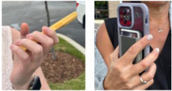
Figure 3. Common blind user phone positions.
Both sighted and BVI users were uncertain about how to properly hold the phone while routing. Although the tutorial states that the phone must be held vertically, with the camera facing outward, sighted and low-vision users often let the phone drift to the left and right. Because the phone needs to be pointed in the direction a user is walking to provide accurate routing directions, this sometimes resulted in conflicting instructions. This issue was even more prevalent with completely blind users, who often struggle with the spatial awareness required to understand how to hold the phone. In extreme cases, users raised the phone sideways or held the camera backward. Sometimes blind participants blocked the camera with fingers. The most common BLV tendency was to let the wrist droop/tilt sideways while walking (Figure 3).
Low-vision users expressed concern that some UI elements were too small and/or did not exhibit enough visual contrast. Although the app was designed to meet Web Content Accessibility Guidelines (WCAG) related to color contrast and UI sizing, low-vision users still had trouble discerning key elements on a smartphone screen, especially when screens contained a lot of visual information.
Figure 4. Floor switcher.
Figure available in the original PDF paper.
Some affordances – the floor switcher and routing buttons – were difficult to understand. Users noted that the standard labelling for the floor switcher, which included an icon and the floor number (Figure 4), didn’t include enough information to be intuitive at first glance. Likewise, users reported that the “start walking” and “avoid stairs” buttons (see Figure 2) necessary to start a route were confusing because they don’t follow routing paradigms already established by apps like Google and Apple maps (typically a GO button). They also shared that it wasn’t immediately obvious that tapping one of these is necessary to start a route. Rather, some users thought the route should start as soon as they select a destination.
Several participants noted that panoramic scanning to localize took too long. If it took longer than 5 to 6 seconds for the app to find a user’s position, they began to wonder if the app was broken and/or became impatient. If it took longer than 10 to 12 seconds, impatience became frustration, and users expressed that if it takes much longer than this, they would not want to use the app.
Many participants shared that the voice speed of routing instructions is too fast, making it difficult to mentally process while routing. BLV users – who are often able to process faster language speeds due to a heightened sense of hearing and language processing – were typically less concerned about voiceover/text-to-speech speeds. However, sighted users often noted that the default language speed was too fast for them to quickly process while in route.
GoodMaps: Assessing an Indoor Navigation App Built on Camera-Based Positioning 553
The discussion that follows expands on how these findings can inform the design of other apps and assistive tools and includes information about how the GoodMaps app has evolved based on this research.
DISCUSSION
It’s worth noting that feedback about the GoodMaps app was generally positive, especially among individuals with disabilities. One focus group wheelchair user shared, “…you can’t imagine how often I struggle to get where I’m going because I have to look for elevators or ramps. This app would make it so much easier for me to get where I want to go quickly, and without help.” Likewise, according to one blind UAT participant, “…this app is magical. It’s unreal. This could be a life changer. If I had access to this in the places I travel – like the grocery, or museums, or hospitals – I could go anywhere I wanted. I know that seems small to you because you can go anywhere you want any time you want. I have never had that kind of independence. This app would change my life.” Users with no reported disability also shared positive feedback, indicating the GoodMaps app would prove useful when exploring an unfamiliar building in advance of a visit, navigating new spaces, and traveling independently. However, designing an assistive tool with the level of functional and design complexity inherent for indoor wayfinding requires a careful balance between intuitive design, clear communication of product affordances, managing user expectations, and understanding diverse user needs. In particular, three findings from this research allude to learnings that can be generalized for assistive tech designers and developers.
First, explaining how novel, complex technologies works in ways that are easy to understand and efficient for app design and experience can be tricky. This is evidenced in two key results from this study: 1) users generally don’t understand how CPS works, and 2) they struggle to properly hold the phone. As previously noted, users must have some understanding of how CPS works to understand why certain actions are required by the GoodMaps app. This is intensified by the fact that most users are familiar with GPS, which functions very differently. Thus, for the user to understand how to use the app, they must also understand that the phone’s camera – not a satellite signal or Bluetooth beacons – plays an integral role in the app’s ability to find their position on the map and provide turn-by-turn directions to a destination. Relatedly, how a user holds the phone affects the app’s ability to provide accurate routing information. All this leads to a wicked design challenge: What is the best way to communicate those critical, complex concepts on small screens? The answer to that question certainly depends on the product itself. But for GoodMaps, it has meant multiple iterations of tutorial design, visualization, and traditional instructions. In Fall 2024, GoodMaps will add an interactive tutorial that allows users to practice using the app. The interactive tutorial will provide visual, voice, haptic, and tonal feedback to alert users when they are “doing it wrong” and to confirm when they are “doing it right.”
554 Palilonis
Second, balancing requirements and/or limitations of a particular technology with users’ expectations for how it should work can also be challenging. For example, designing for smartphones is often impeded by the need to communicate many complex concepts (sometimes all at once) on a very small screen. On face value, this may seem like usability design 101. However, this really highlights a more advanced UI/UX design concept that relates to how designers decide what can be delivered at a higher level of abstraction and what needs to be more blatantly communicated to ensure user understanding. In other words, sometimes an abstract icon is perfect for communicating a complex concept on a small screen. However, when abstraction leads to confusion, more visual, textual, and/or verbal modes of communication may be necessary. Although this approach isn’t likely to be space conservative, it may be the only way to ensure understanding. As such, future versions of the GoodMaps design include more detailed labelling on affordances like the floor switcher, routing buttons, and more.
Third, even when accessibility guidelines were followed for UI design, low- vision users in particular still struggled to discern information on maps and routing screens, with some calling for more color and sizing contrast than even WCAG requires. This illuminates the critical value that testing with differently abled users brings to the design and development process. The GoodMaps app represents a relatively complex visual interface, suggesting that perhaps, the more complex a small-screen interface is, the more a design should compensate with increased levels of visual contrast, spacing, sizing, etc.
It is worth noting that many research-informed improvements have been made to the GoodMaps interface since this study was conducted. These include: decluttering of the visual interface when possible, optimizing voice speed for all users, faster localization speeds (now 2 to 3 seconds), revised routing buttons to mirror familiar design paradigms (GO button), enhanced tutorials, redesigned UI elements for better recognition and recall, and more.
CONCLUSION & FUTURE RESEARCH Since the completion of this research, the GoodMaps app has undergone a continuous, iterative design and development to improve the experience. The design team engages in an Agile process, through which improvements are made and the app is updated in regular, two-week sprints. Future research will explore the extent to which indoor wayfinding support affects disabled users’ feelings of independence and self-determination, as well as their quality of life and work.
REFERENCES
Abraham, C. H., Boadi-Kusi, B., Morny, E. K. A. and Agyekum, P., 2022. Smartphone usage among people living with severe visual impairment and blindness. Assistive Technology, 34(5), pp. 611–618. Ahmetovic, D., Gleason, C., Ruan, C., Kitani, K., Takagi, H. and Asakawa,
C., 2016, September. NavCog: A navigational cognitive assistant for the blind.
GoodMaps: Assessing an Indoor Navigation App Built on Camera-Based Positioning 555
In Proceedings of the 18th International Conference on Human-Computer Interaction with Mobile Devices and Services (pp. 90–99). Depountis, V., Okungu, P. and Molloy-Daugherty, D., 2019. The development of an application that supports body awareness for children with visual impairments and additional disabilities. Vision Rehabilitation International, 10(1), pp. 1–8. Faria, J., Lopes, S., Fernandes, H., Martins, P. and Barroso, J., 2010, September.
Electronic white cane for blind people navigation assistance. In 2010 World Automation Congress (pp. 1–7). IEEE. Griffin-Shirley, N., Banda, D. R., Ajuwon, P. M., Cheon, J., Lee, J., Park, H. R.
and Lyngdoh, S. N., 2017. A survey on the use of mobile applications for people who are visually impaired. Journal of Visual Impairment & Blindness, 111(4), pp. 307–323. Kapsalis, E., Jaeger, N. and Hale, J., 2024. Disabled-by-design: effects of inaccessible urban public spaces on users of mobility assistive devices–a systematic review. Disability and Rehabilitation: Assistive Technology, 19(3), pp. 604–622. Lindsay, S., & Lamptey, D. L. (2019). Pedestrian navigation and public transit training interventions for youth with disabilities: A systematic review. Disability and rehabilitation, 41(22), 2607–2621. Liu, L., Li, B., Zlatanova, S. and van Oosterom, P., 2021. Indoor navigation
supported by the Industry Foundation Classes (IFC): A survey. Automation in Construction, 121, p. 103436. McNicholl, A., Desmond, D. and Gallagher, P., 2023. Assistive technologies, educational engagement and psychosocial outcomes among students with disabilities in higher education. Disability and Rehabilitation: Assistive Technology, 18(1), pp. 50–58. Nakajima, M. and Haruyama, S., 2012, August. Indoor navigation system for
visually impaired people using visible light communication and compensated geomagnetic sensing. In 2012 1st IEEE International Conference on Communications in China (ICCC) (pp. 524–529). IEEE. Saldana, J., 2011. Fundamentals of qualitative research. Oxford university press. Smith, E. M., Huff, S., Wescott, H., Daniel, R., Ebuenyi, I. D., O’Donnell, J., Maalim, M., Zhang, W., Khasnabis, C. and MacLachlan, M., 2024. Assistive technologies are central to the realization of the Convention on the Rights of Persons with Disabilities. Disability and Rehabilitation: Assistive Technology, 19(2), pp. 486–491. UNICEF (2022) Global report on assistive technology. Available at https://www.un
icef.org/reports/global-report-assistive-technology (Accessed 11 March 2024).
LISTED IN THE AHFE DIGITAL BOOKSTORE CATALOGUE
Explore the complete digital volume
Human Interaction and Emerging Technologies (IHIET 2024)
Read this individual research paper free through the original publisher, or explore the full digital proceedings book.
ISBN 978-1-964867-33-5
Explore this ISBN in the AHFE Bookstore ↗Listed in the July 2026 bookstore catalogue; search by ISBN to confirm current availability · Digital book purchase optional