Xiaohan Mei, Shengxi Cao, Haiming Zhao, Li Zhang (2026). Distinct Roles of Route and Node Memory in Indoor Wayfinding: Evidence from a Virtual Reality Study. In: Human Factors in Architecture, Sustainable Urban Planning and Infrastructure. AHFE Open Access, vol. 229, pp. 51–60. https://doi.org/10.54941/ahfe1007953
Large public buildings often pose wayfinding challenges, which can affect users’ spatial experience and comfort. Understanding how people navigate these environments is important for both design and experimental research. How people navigate indoor spaces depends on how they remember paths and decision points. This study looks at how two types of memory – route-based and node-based -- affect wayfinding performance in virtual reality (VR) environments. Participants completed wayfinding tasks in four representative layouts and subsequently reconstructed their travelled routes and visited decision points. We analysed how route memory and node memory predicted wayfinding efficiency. The results show that in linear, corridor-like layouts, wayfinding performance is mainly linked to route memory. In layouts with open activity spaces at intersections or central nodes, node memory becomes more important. Some layouts showed no clear link with either memory type, suggesting that the influence of route and node information varies with spatial layout.These findings demonstrate that route and node memory play distinct roles in indoor wayfinding, influenced by spatial configuration, and provide empirical guidance for VR-based studies on spatial cognition and experimental design. Understanding these patterns can also inform building design and layout strategies to improve users’ wayfinding experience in complex indoor environments.
Wayfinding, the process of finding the way to a destination using cues given by the environment (Arthur & Passini, 2002; Lynch, 1964), is a crucial component of the interaction between people and space, deeply influencing the quality of spatial experience. Large public buildings, such as office buildings, hospitals, shopping centres, and transportation hubs, often present challenges for wayfinding. Although advancements in indoor positioning technologies have led to navigation systems that can guide users to destinations within indoor spaces, the general applicability of these technologies remains limited (Zhang et al., 2022). Therefore, spatial cognition remains one of the primary factors
for successful wayfinding, and understanding how people navigate complex indoor environments is essential for both user experience and spatial design.
Previous studies have shown that wayfinding efficiency depends on how individuals perceive and remember spatial information. A classic and well- established framework for studying spatial cognition is the concept of the cognitive map. Lynch (1964) studied urban space by inviting participants to draw maps from memory, highlighting common characteristics of urban experience. Building on this foundation, later work refined cognitive maps into different types of spatial knowledge. In particular, two key types of cognitive representation are widely discussed: (1) route memory, capturing the sequence of paths travelled, and (2) node memory, representing decision points or junctions encountered along the way (Arthur & Passini, 2002). These two forms of memory are widely used to study wayfinding. Related studies have examined spatial cognition from complementary perspectives. For example, Meilinger et al. (2013) distinguished between route knowledge and survey knowledge in navigation learning. Golledge et al. (2000) spatial abilities and human wayfinding, particularly in the context of traveling without the use of sight. Initially we discuss the nature of cognitive maps and the process of cognitive mapping as mechanisms for developing person to object (egocentric provided a comprehensive review of how cognitive maps mediate the relationship between spatial abilities and human wayfinding behaviour. Waller and Lippa (2007) further showed that landmarks serve both as beacons and associative cues in facilitating route learning. Yesiltepe et al. (2021) provided a comprehensive review of landmarks in wayfinding, highlighting the importance of node memory in route learning. However, little is known about how route- and node-based memory contribute differently to wayfinding efficiency across varying indoor layouts.
VR technology has increasingly been applied in indoor wayfinding research, as wayfinding behaviour in virtual environments has been shown to resemble real-world behaviour (Natapov et al., 2022). For example, Qiu et al. (2021) demonstrated that VR technology can be effectively applied to cognitive research on guide signage through a series of wayfinding experiments in parking environments. Vizzari (2020) showed that participant position data collected in VR experiments can be directly used without requiring extensive preprocessing. Similarly, Feng et al. (2022) found that route choice, exit selection, and user experience are generally consistent between head-mounted display (HMD) VR and desktop VR setups. Compared to field experiments, VR enables precise control over spatial layout and experimental conditions, allowing researchers to systematically manipulate environmental features and test their effects on navigation. Additionally, traditional approaches for collecting trajectory data, including GPS and Wi-Fi, generally capture group- level movement patterns rather than precise individual paths. Alternative methods such as Ultra-Wideband (UWB) and Bluetooth can provide individual-level data but often entail high costs and inconsistent quality. Wayfinding experiments in VR, however, can capture precise individual spatiotemporal trajectories (Chen et al., 2023; Ewart & Johnson, 2021; Sun et al., 2022) providing a valuable opportunity to investigate how different spatial layouts influence cognitive strategies and wayfinding efficiency.
Distinct Roles of Route and Node Memory in Indoor Wayfinding 53 Based on this analysis, the present study examines the roles of route- and node-based memory in wayfinding across four representative VR indoor layouts, enabling a controlled comparison of cognitive strategies under different spatial configurations.
METHODS
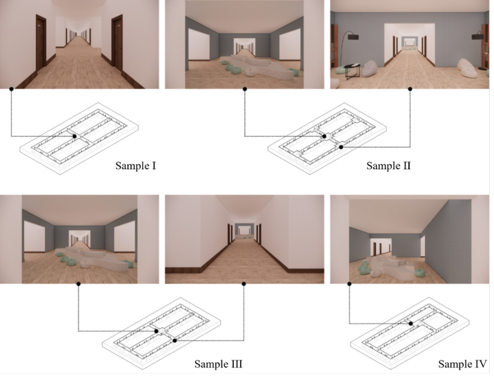
Experimental Scenes To study how different spatial layouts influence cognitive strategies and wayfinding efficiency, we selected four representative indoor layouts to illustrate distinct spatial configurations (Figure 1). All layouts were based on a grid-like “田” structure, commonly found in public buildings such as educational or office facilities. This layout divides space into multiple regions, providing sufficient structural variation for experimental comparison while avoiding overly simple or overly complex configurations. Layouts with fewer regions (e.g., single-cell or 日-shaped) would offer limited variation, while more complex layouts may introduce excessive wayfinding difficulty for participants. Using a familiar educational office building as the spatial interface also helps participants feel immersed, leading to more realistic wayfinding behaviour.
Figure 1: Experimental scenes (Source: authors).
Sample I (Straight Grid) represents a fully linear corridor space, where the visual interface consisted only of walls and doors. Rooms were numbered clockwise within the four regions labelled A–D (e.g., A301, A302, D301).
Sample II (Intersection Activity) extends Sample I by introducing open activity spaces at each corridor intersection. These spaces included typical features found in educational or office buildings, such as seating areas and water dispensers. Room numbering followed the same logic as Sample I to ensure that differences in numbering did not influence participants’ spatial cognition.
Sample III (Central Activity) is also derived from Sample I but includes an activity space only at the central corridor intersection, equipped with seating similar to that in typical educational environments. Room numbering remained consistent with Sample I.
Sample IV (Offset Grid) modifies the corridor positions from Sample I, resulting in four regions of unequal size. The central intersection includes the same seating configuration as in Sample III. Room numbering remained consistent with Sample I to maintain comparability.
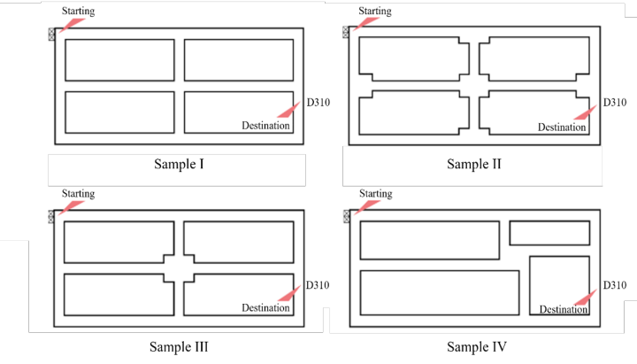
For all four layouts, the wayfinding start point and destination were identical: participants started from the elevator and were asked to locate a designated target room D310 (Figure 2). This setup simulates a first-time visitor searching for a specific destination, providing a realistic context for evaluating wayfinding behaviour.
Experimental Environments and Apparatus The experiments were conducted using a desktop-based VR system. The experimental scenes were developed using the Unity 3D engine, with C# scripts implemented to support wayfinding interaction and trajectory data collection. All experiments were conducted in the Urban Ergonomics Lab,
Distinct Roles of Route and Node Memory in Indoor Wayfinding 55 School of Architecture, Tsinghua University. The experimental system was implemented on a workstation equipped with an Intel Core i9 processor and an NVIDIA GeForce RTX 4090 GPU.
Participants A total of 37 participants (21 females, 16 males; ages 18-50) with normal or corrected-to-normal vision participated in the original large-scale experiment, which included 27 virtual indoor layouts. Each participant completed 10 randomly selected layouts.
For the present study, we focus on four representative layouts – Straight Grid, Intersection Activity, Central Activity, and Offset Grid – as examples of different spatial configurations. Across these four layouts, a total of 62 valid wayfinding trials were obtained from the larger dataset.
All participants’ trajectories and reconstructed cognitive maps from these layouts were included in the analysis. Although the current analysis uses only these four layouts, the data were collected within the context of the full 27-layout experiment, ensuring that each participant had prior exposure to a variety of spatial environments and that wayfinding behaviour reflects realistic variation in strategy use.
Participants received a compensation of 30 to 40 RMB upon completing the experiment. Prior to the experiment, participants were informed about the tasks they would perform and data collection procedures, and they signed an informed consent form. The study was approved by the ethics committee of Tsinghua University.
Experimental Procedure Before the experiment, participants were instructed on how to interact with the virtual environment, including moving forward and backward, turning, jumping, running, and drawing cognitive maps. Participants practiced these interactions in a training scene until they were familiar with the controls.
At the beginning of each trial, an experimental scene was randomly presented, and data recording started. Participants began at the elevator and were required to independently find the target room.
When participants believed they had reached the destination, they clicked a “confirm” button to end the trial, and data recording stopped. If they were unable to locate the target, they could choose to terminate the trial, in which case the wayfinding efficiency was recorded as zero.
After each trial, a simplified boundary of the layout was presented, and participants were asked to reconstruct their travelled routes and visited nodes based on memory using a mouse interface.
Measures To investigate how different spatial layouts influence cognitive strategies and wayfinding efficiency, we measured wayfinding performance and spatial cognition during indoor wayfinding tasks.
Wayfinding Efficiency was quantified by first defining a valid route as a path taken by a participant that involves no detours and is traversed only once. The ratio of the time spent on the valid route to the total wayfinding time was then used as an evaluation metric for efficiency (Mei & Zhang, 2025). This approach closely reflects participants’ subjective experience of wayfinding performance.
Route Memory Accuracy (RMA) was calculated to evaluate how accurately participants remembered the paths they travelled. Specifically, RMA was computed as the similarity between the routes reconstructed in participants’ cognitive maps and their actual trajectories, using bidimensional regression and mean squared error measures (Friedman & Kohler, 2003). Higher RMA values indicate more accurate route memory.
Node Memory Accuracy (NMA) was used to evaluate participants’ memory of decision points or topological nodes. NMA was computed based on the difference between the number of times participants passed through nodes in their cognitive maps and the actual trajectories. To account for the fact that memory accuracy naturally decreases as the number of nodes increases, the total number of nodes actually traversed was used as a normalization factor (Mei, 2025). Higher NMA values indicate more accurate memory of nodes.
By analysing the relationships between wayfinding efficiency and the two types of memory, we can identify the cognitive strategies participants rely on under different spatial layouts. If RMA is significantly correlated, participants rely primarily on route memory. If NMA is significantly correlated, participants rely on node memory. If neither RMA nor NMA is correlated with efficiency, participants may depend more on external cues, such as signage, suggesting that the spatial structure may be too complicated to recognise during wayfinding.
RESULTS AND DISCUSSION
Wayfinding efficiency was first examined across the four representative VR layouts (Table 1). All layouts exhibited high efficiency, with mean wayfinding efficiency ranging from 93.0% to 95.8%.
Table 1: Wayfinding efficiency of experimental scenes with different layouts (Source: authors).
Table available in the original PDF paper.
Median
Layout Activity Space Number
Central Node Location
Mean Standard Deviation Straight Grid 0 Central 95.8% 5.9% 100%
5 Central 95.1% 6.1% 97.8%
Intersection Activity 1 Central 93.0% 8.7% 96.5% Central Activity
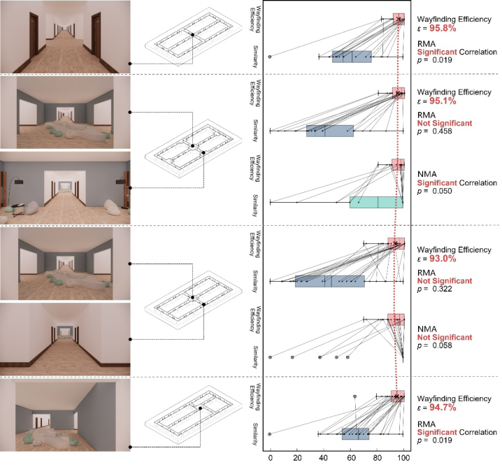
Offset Grid 1 Eccentrical 94.7% 5.8% 97.5% We then analysed the correlation between wayfinding efficiency and RMA for each layout (Figure 3). In the Straight Grid and Offset Grid layouts, wayfinding efficiency was significantly correlated with RMA (Straight
Distinct Roles of Route and Node Memory in Indoor Wayfinding 57 Grid, p = 0.019; Offset Grid, p = 0.019), indicating that participants relied primarily on route memory to guide their wayfinding. In contrast, in the Intersection Activity and Central Activity layouts, the correlation was not significant (Intersection Activity, p = 0.458; Central Activity, p = 0.322), suggesting that participants relied on other types of spatial memory or cues in these configurations.
For the layouts where wayfinding efficiency and RMA were not correlated, we further examined the correlation between wayfinding efficiency and NMA (Figure 3). In the Intersection Activity layout, where open planar spaces were introduced at corridor intersections, participants’ wayfinding efficiency was significantly correlated with NMA (p = 0.050), demonstrating that participants relied on node memory to guide wayfinding. In the Central Activity layout, where only a single planar space was located at the central intersection, participants tended to rely on node memory, while the correlation was near-significant (p = 0.058).
Figure 3: Correlation between wayfinding efficiency and memory accuracy (Source: authors).
These analyses indicate that participants’ cognitive strategies varied systematically with spatial layout: linear or eccentrical layouts promoted route-based wayfinding, whereas layouts with planar activity spaces at intersections or central nodes promoted node-based wayfinding.
For the Straight Grid layout, no activity spaces were introduced in the environment. In this case, participants’ wayfinding efficiency increased when they had a clearer understanding of their position within the space and the sequence of paths they had taken, indicating a reliance on route memory.
For the Intersection Activity and Central Activity layouts, where activity spaces functioned as identifiable nodes, participants tended to rely more on the relationship between their current position and these nodes during wayfinding. Notably, compared to the Straight Grid layout, the overall “ 田”-shaped spatial structure remained unchanged, and only planar activity spaces were added. However, this modification led to a shift in cognitive strategy from route-based to node-based wayfinding. This suggests that increased spatial complexity can alter users’ cognitive strategies, without necessarily reducing wayfinding efficiency.
When the central activity space was shifted from the centre to an off-centre position, transforming the Central Activity layout into the Offset Grid layout, the overall spatial topology and elements remained unchanged. However, route memory once again became significantly correlated with wayfinding efficiency, and overall performance slightly improved. This suggests that asymmetrical spatial configurations may help users better orient themselves within the environment and reinforce route memory, thereby improving wayfinding efficiency.
CONCLUSION
This study investigated how different indoor spatial layouts influence cognitive strategies and wayfinding efficiency in virtual environments. Rather than directly determining wayfinding efficiency, spatial layout shapes the cognitive strategies users adopt, which in turn influence performance. By comparing four representative “田”-shaped layouts, the results demonstrate that wayfinding efficiency is closely related to the type of spatial memory participants rely on, and this reliance varies systematically with spatial configuration.
The study contributes two key findings. First, it shows that different spatial layouts lead to different modes of spatial cognition. More accurate route memory or node memory does not necessarily guarantee higher wayfinding efficiency. Second, the results reveal that increasing spatial complexity or introducing additional spatial elements does not necessarily reduce wayfinding efficiency. Rather, users may adapt by shifting their cognitive strategy, for example, from route-based to node-based navigation.
These findings provide practical implications for spatial design. Designers can enhance wayfinding performance by aligning spatial cues with expected cognitive strategies. For example, nodes can be reinforced through the introduction of activity spaces in complex layouts. The results also suggest that asymmetry in spatial configurations may help users better orient themselves within the environment and improve route-based navigation.
This study also has several limitations. The analysis is based on a limited number of representative layouts, and future research could include a wider range of spatial configurations to improve generalisability. In addition, this study examines route memory and node memory separately; future work
Distinct Roles of Route and Node Memory in Indoor Wayfinding 59 could integrate these measures with visual perception data to develop quantitative models for predicting wayfinding efficiency. More objective measurements of cognitive processes, such as neurophysiological data (e.g., EEG or fMRI), could also be incorporated to better understand how cognitive maps are formed during wayfinding (Woollett & Maguire, 2011). Overall, this study highlights the importance of considering cognitive strategies in the design of indoor environments to improve wayfinding performance and user experience.
ACKNOWLEDGMENT
This study is funded by the National Natural Science Foundation of China (Grant No. 52278023).
REFERENCES
Arthur, P., & Passini, R. (2002). Wayfinding: People, Signs, and Architecture. Focus Strategic Communications. Chen, J., Shi, Y., & Li, N. (2023). The role of selective attention in emergency
wayfinding: An eye tracking-integrated virtual reality experiment. Safety Science, 168, 106320. Ewart, I. J., & Johnson, H. (2021). Virtual reality as a tool to investigate and predict occupant behaviour in the real world: The example of wayfinding. ITcon, 26, 286–302. Feng, Y., Duives, D. C., & Hoogendoorn, S. P. (2022). Wayfinding behaviour in a
multi-level building: A comparative study of HMD VR and Desktop VR. Adv. Eng. Inform., 51(C). Friedman, A., & Kohler, B. (2003). Bidimensional Regression: Assessing the Configural Similarity and Accuracy of Cognitive Maps and Other Two-Dimensional Data Sets. Psychological Methods, 8(4), 468–491. G.Golledge, R., Jacobson, R. D., Kitchin, R., & Blades, M. (2000). Cognitive Maps,
Spatial Abilities, and Human Wayfinding. Geographical Review of Japan, Series B., 73(2), 93–104. Lynch, K. (1964). The Image of the City. The MIT Press. Mei, X. (2025). Key Cues for Wayfinding in Windowless Spaces with Complex Circulation in Large Public Buildings. Tsinghua University; Politecnico di Torino. Mei, X., & Zhang, L. (2025). Bridging Subjective Experience and Objective Measures:
A Novel Method for Assessing Indoor Wayfinding Efficiency Using Virtual Environments. Human Factors in Architecture, Sustainable Urban Planning and Infrastructure, 191(191). Meilinger, T., Frankenstein, J., & Bülthoff, H. H. (2013). Learning to navigate: Experience versus maps. Cognition, 129(1), 24–30. Natapov, A., Parush, A., Laufer, L., & Fisher-Gewirtzman, D. (2022). Architectural
features and indoor evacuation wayfinding: The starting point matters. Safety Science, 145, 105483. Qiu, H., Fang, W., Bao, H., & Wang, X. (2021). A Feasibility Study of Virtual Reality Technology in Guidance Design of Underground Space. In F. Rebelo (Ed.), Advances in Ergonomics in Design (pp. 605–613). Springer International Publishing. Sun, C., Li, S., Lin, Y., & Hu, W. (2022). From Visual Behavior to Signage Design: A
Wayfinding Experiment with Eye-Tracking in Satellite Terminal of PVG Airport (p. 262).
Vizzari, G. (2020). Virtual Reality to Study Pedestrian Wayfinding: Motivations and an Experiment on Usability. 2020 IEEE International Conference on Artificial Intelligence and Virtual Reality (AIVR), 205–208. Waller, D., & Lippa, Y. (2007). Landmarks as beacons and associative cues: Their
role in route learning. Memory & Cognition, 35(5), 910–924. Woollett, K., & Maguire, E. A. (2011). Acquiring “the Knowledge” of London’s Layout Drives Structural Brain Changes. Current Biology, 21(24), 2109–2114. Yesiltepe, D., Conroy Dalton, R., & Ozbil Torun, A. (2021). Landmarks in wayfinding:
A review of the existing literature. Cognitive Processing, 22(3), 369–410. Zhang, N., Fu, W., Meng, R., Li, G., Zhao, Z., Yang, J., & Wang, C. (2022). A review of indoor space positioning methods. Science Technology and Engineering, 22(3), 882–892. [张宁, 付炜平, 孟荣, 李光, 赵智龙, 杨家骏, & 王淳灏. (2022). 室内空间 定位方法研究综述. 科学技术与工程, 22(3), 882–892.]
LISTED IN THE AHFE DIGITAL BOOKSTORE CATALOGUE
Explore the complete digital volume
Human Factors in Architecture, Sustainable Urban Planning and Infrastructure
Read this individual research paper free through the original publisher, or explore the full digital proceedings book.
ISBN 979-8-950676-05-5
Explore this ISBN in the AHFE Bookstore ↗Listed in the July 2026 bookstore catalogue; search by ISBN to confirm current availability · Digital book purchase optional