Serge Chaumette (2025). Conflict-Free Swarm Shape Formation with Minimal Operator Involvement. In: Human Factors in Design, Engineering, and Computing. AHFE Open Access, vol. 199, pp. 1289–1297. https://doi.org/10.54941/ahfe1006940
Swarms of drones are used in both shows and operational missions (civilian and military). They are complex systems that raise a number of technical issues. Among these is the following. Whatever the context, the members of the swarm must organize according to patterns (or shapes) that depend on the show/mission at hand. To form a given shape, the drones of the swarm must take off and then fly to their respective position of operation (or target position) without colliding with one another. For shows, drones have positions to reach that are known long in advance (i.e. when the show is defined) and their optimal collision free flight path from the ground to this position can consequently be computed off-line, before the show. This can also be supported by the fact that the drones can be organized in an ad hoc on the ground before take-off manner since time permits. For operational missions, it is necessary to act fast and there is no time neither to configure an application that would precompute paths to form a given pattern, nor to organize the drones on the ground to make shape formation easier. Still, if no care is taken, it is most likely that a number of drones will collide with one another (which becomes increasingly likely as swarm size grows). The goal of our work is to address this issue. It should be noted that the possible dynamic behavior of the swarm once the drones have reached their target positions is out of the scope of our current work. Of major importance is addressing the human factor and more precisely the load that is put on the operator. The perfect system should obey the following mode of operation: (i) the operator dispatches the drones on the ground without any position constraint; (ii) each drone is then provided with its current position (that can be acquired by using a GNSS) and its target position. (iii) the operator presses the “start mission” button, and the drones automatically fly to their positions of operation; (iv) the mission is run ; (v) the drones automatically flight back to their original (home) positions; (vi) the operator returns each drone to the storage unit. This closes the mission. In this work, we describe a number of tentative approaches from the literature, others that we have experimented in earlier studies, and those that we are currently developing.
For shows, drones have positions to reach that are known long in advance (i.e. when the show is designed) and their optimal collision free flight paths from the ground to their position in the target shape can consequently be computed off-line, before the show. The fact that the drones can be organized in an ad hoc manner on the ground before take-off, since time permits, also facilitates the process. For missions deployed for instance by first responders, it is necessary to act fast and there is not really any time neither to configure an application that would precompute paths to form a given pattern, nor to organize the drones on the ground to make shape formation easier. Still, if no care is taken, it is most likely that a number of drones will collide with one another (which becomes increasingly likely as swarm size grows). The goal of our work is to address this issue. It should be noted that the possible dynamic behavior of the swarm (i.e. drones moving around) once the drones have reached their positions in the target shape is out of the scope of this paper. A founding issue of our work which is of major importance is addressing the human factor and more precisely the load that is put on the operator (Ghasempour et al., 2025). We believe that an appropriate system should obey the following mode of operation: (i) the operator dispatches the drones on the ground without any position constraint; (ii) each drone is then provided with its current position (that can be acquired by using a GNSS) and its target position. (iii) the operator presses the start mission button, and the
drones automatically fly to their positions of operation in the target shape; (iv) the mission is run; (v) the drones automatically fly back to their original (home) positions; (vi) the operator returns each drone to the storage unit. This closes the mission.
In this paper, we describe a number of approaches that we have experimented in earlier studies, and the approach that we are currently developing.
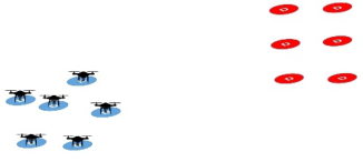
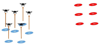
USE CASE AND DEFINITIONS The problem that we are addressing is not a purely theoretical problem. A real world scenario is the surveillance of a given area with drones having different sensors (chemical nose, camera, radiation sensor, etc.), each required to operate at a specific location (i.e. their positons cannot be switched between each other), altogether making a global shape. From a formal point of view we have a set of Drones (D), a set of initial or Take-Off Positions (TOP), a set of Target Shape Positions (TSP),and a bijection between each of these sets. We also introduce the notion of Mission Start Positions (MSP) that are slightly different from TOPs: the drones initially have to takeoff (from TOPs) and reach a low altitude position, their MSPs, to effectively start their mission. These acronyms are listed in Table 1.
Table 1: Acronyms used in this paper.
Table available in the original PDF paper.
D Drone TOP Take off Position MSP Mission Start Position TSP Target Pattern Position
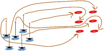
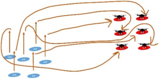
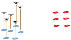
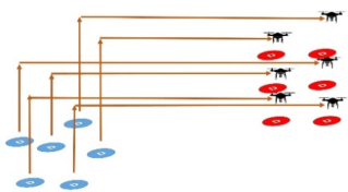
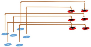
2D STRATEGY We call this approach 2D strategy because it relies on planar graphs. Indeed the graph that maps the MSPs to the TSPs is planar: it can contain neither K33 nor K5 (Wagner’s theorem (Wagner, 1937)) whatever the configuration since each drone is required to reach one single shape point and each point in the target shape is the target of one single drone. It is thus possible to find a path (see Figure 3) from each starting point to its associated point in the target shape without any intersection with the paths of the other drones. Collisions are thus impossible.
Discussion/Limitations This approach is easy to implement from a computational perspective and requires no synchronization between the drones. Still it is necessary to precompute the paths and to upload these paths into the drones.
From an operational point of view, the operator has to feed the application in charge of computing the paths with the initial position and the target position of each drone. Once fed with its respective path, each drone is unique and requires individual handling. The operator must thus ensure that each drone is deployed for take-off in accordance with its assigned flight path. This puts an heavy load on its shoulders.
Conflict-Free Swarm Shape Formation With Minimal Operator Involvement 1291
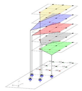
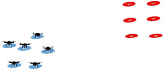
Figure 1: Drones at take off positions.Figure 2: Drones at mission start positions.Figure 3: 2D paths.Figure 4: Drones at target/mission shape positions.
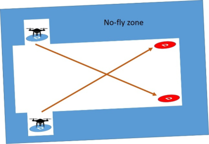
Still there are configurations where even though the theoretical graph that links MSPs to TSPs is planar it cannot be dealt with this approach because of external constraints such as infrastructures for instance. An example is shown Figure 5.
The underlying graph is planar, but the no-fly zone (e.g. a building) shown on the figure makes it impossible to use this property to draw disjoints paths. Additionally, when large swarms are considered, this approach leads to long and tangled paths that are difficult to handle from a practical point of view.
1292 Serge
Figure 5: Planar mission with no planar representation.
3D STRATEGIES 3D strategies take advantage of the third dimension to move the drones from their TOPs to their TSPs. Indeed, when using the third dimension, it is often possible to temporarily share (at least part of) the flight zone in a compartmentalized way between the drones, for instance by giving each drone a specific flight level.
These approaches must of course be used when the context makes it impossible to use the 2D approach described above (examples of ad hoc safe positions are shown Figure 5). But in any configuration, even when the above 2D approach applies, they offer a number of advantages that will clearly appear below.
A FIRST 3D STRATEGY – DESIGNED AND USED IN THE CARUS PROJECT The goal of the CARUS project (Chaumette et al., 2011) was to show the feasibility of flying a resilient autonomous swarm of drones1. As far as we know, this has been the first swarm of this kind ever operated. The example use case was the surveillance of a set of points of interest located on the ground. In this project, we solved the issues of entering the formation (i.e. taking off safely), reaching the target points without any collision, and eventually getting back home, by defining specific take-off positions of the drones on the ground (Figure 6 and Figure 7). Maintaining different altitudes among the drones reduced the overall complexity of the problem. To address the surveillance process, the drones, when required, flew down from their target positons close to the ground. To avoid collisions during this phase, we introduced specific flight corridors (but his is out of the scope of this paper, the interested read is refereed to (Laplace, 2012).
1This project has been developed by the LaBRI (the Computer Science Research Laboratory of the University of Bordeaux), Thales Group and Fly-n-Sense, with the support of Région Nouvelle-Aquitaine and DGA (the French Defence Procurement Agency).
Conflict-Free Swarm Shape Formation With Minimal Operator Involvement 1293
Discussion/Limitations This approach requires no precomputation and no synchronization between the drones.
Still it puts load on the operator who must deploy the drones on the ground according to the take-off shape defined for the mission at hand. It only applies to missions where drones operate at different altitudes.
A SECOND 3D STRATEGY – DESIGNED AND USED IN THE ASSYDUS PROJECT The use case considered in the ASSYDUS project (ANR, French National Research Agency, 2021) consisted in the passive deception of an enemy radar by making an autonomous swarm of drones appear as a single, larger, and substantially more threatening aircraft2. To achieve this goal a number (a swarm) of drones were deployed on the ground and took off to reach
2This project (ANR-21-ASRO-0006) has been developed by Thales Group and the LaBRI (the Computer Science Research Laboratory of the University of Bordeaux), with the support of DGA (the French Defence Procurement Agency).
1294 Serge
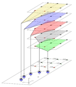
their assigned positions in the target shape. In this project, moving the drones from their initial positions to their target positions heavily relied on synchronization. The drones are first taken to different levels (one level each). Once there, they synchronize (Figure 9) to make sure that each of them has reached its level. Once synchronized, they then move to the vertical of (above) the position of their final destination. Each having a different flight level, there is no risk of collision during this phase. Then they synchronize again (Figure 10) and fly down to their work altitude (Figure 11).
Figure 8: Drones at take off positions.Figure 9: First synchronization.Figure 10: Second synchronization.Figure 11: Drones at mission pattern positions.
Conflict-Free Swarm Shape Formation With Minimal Operator Involvement 1295
Discussion/Limitations This approach is relatively easy to implement and puts little load on the operator.
Still it requires two synchronizations between the drones which is a major issue: a communication framework must be instantiated, it is subject to jamming or denial of service attacks, and the system loses some furtiveness.
A NOVEL 3D STRATEGY The major issues for each drone with the above approaches are those of: (i) reaching a transit level that makes it possible for it to fly towards its target point in the mission shape without any risk to collide with another drone that would be flying upwards to its own transit level or downwards to its operation level; (ii) flying down from its transit level to its operation level without crossing the trajectory of another drone. And of course we have the same issues on the way back.
In what follows, we describe the novel approach that we propose to address these problems.
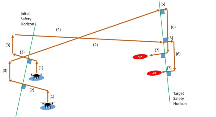
First, we define a plan past the furthest Target Shape Position (which we call Target Safety Horizon, shown for the sake of simplicity as a green line on the right of Figure 12) and a plan prior the furthest Take-Off Position (which we call Initial Safety Horizon, shown as a green line on the left of Figure 12).
As explained above (CARUS approach), issue (i) can be achieved by physically organizing all the drones in a specific configuration on the ground. This puts load on the operator. To avoid this load we propose to achieve this first step dynamically. The drones are first raised to a certain altitude (lines (1) Figure 12). They then align prior to the initial safety horizon (lines (2)) using parallel (thus collisions free) trajectories (built using the shared horizon) and move to their Mission Start Positions (lines (3)), which are located at different levels. This solves issue (i). Once there, they can circulate on a 2D plan without any risk to interfere with the trajectory of any other drone, each having its own altitude. Achieving this first phase only requires to provide each drone with the initial safety horizon. There is no collaboration and no synchronization required.
Once reaching their transit level (Mission Start Positions), the drones fly towards the target safety horizon, more precisely towards the projection of their TSP on this horizon (lines (4) Figure 12). Then they fly past this horizon in a parallel manner (lines (5)) (built using the shared horizon), still aligned in some sense with their target shape position. They can eventually fly down (lines (6) and backwards (lines (7)) to their target point. This solves issue (ii).
A symmetric process is used to get back home.
Discussion/Limitations Using this approach, the operator can freely deploy the drones on the ground without any constraint. Additionally, this strategy requires no synchronization between any of the drones.
The only information that needs to be shared between the members of the swarm are the safety horizons that need to be computed before takeoff.
1296 Serge
Figure 12: A 3D strategy without any synchronization.
SUMMARY AND COMPARISON OF THE DIFFERENT APPROACHES We summarize and compare the approaches that we have presented in this paper in Table 2. It shows that the new strategy that we propose is the most effective in balancing the workload of the operator with the technical complexity of the system.
Table 2: Summary and comparison of the different approaches.
Table available in the original PDF paper.
2D Strategy 3D Strategy/ CARUS
3D Strategy/ ASSYDUS
3D Approach/ New Strategy
Large number of drones supported Pre-computation Operator load
To summarize, this novel strategy works as follows: (i) the operator dispatches the drones on the ground without any position constraint; (ii) each drone is then provided with its current position (that can be acquired by using a GNSS), its target position and the safety horizons. (iii) the operator
Conflict-Free Swarm Shape Formation With Minimal Operator Involvement 1297
pressses the start mission button, and the drones automatically fly to their positions of operation in the target shape; (iv) the mission is run; (v) the drones automatically flight back to their original (home) positions; (vi) the operator returns each drone to the storage unit. This closes the mission.
This mode of operation matches the (constraints of the) one we described in the introduction of this paper. It puts very little load on the operator. The only precomputation that is required is that of the safety horizons and it requires no synchronization between the drones.
FUTURE WORK
The work presented in this paper is preliminary. A more formal definition of the problem is under development. Once done, a theoretical validation will be built, simulations implemented and we will eventually finish with a demonstration on the field.
ACKNOWLEDGMENT
The author would like to thank all the persons who have worked on the projects and thesis referenced in this paper.
REFERENCES
Abdelkader, M., Güler, S. & Jaleel, H., 2021. Aerial Swarms: Recent Applications and Challenges. Curr Robot Rep, Issue 2, pp. 309–320. ANR, French National Research Agency, 2021. AutonomouS SYstem for Decoying
using Uav Swarms – ASSYDUS. Available at: https://anr.fr/Project-ANR-21- ASRO-0006. Chaumette, S., 2016. Chapter 8: Cooperating UAVs and Swarming. Dans: UAV Networks and Communications. Cambridge Press. Chaumette, S. et al., 2011. CARUS, an operational retasking application for a swarm
of autonomous UAVs: First return on experience. Baltimore, IEEE. Laplace, R., 2012. Applications et services DTN pour flotte collaborative de drones.
PhD Thesis disertation. Matin Ghasempour, A., Tazim, A., Shuchisnigdha, D. & Mahmudur, R., 2025.
Cognitive Workload in Drone Operations: A Literature Review and Conceptual Framework. Institute of Industrial and Systems Engineers (IISE), pp. 1–6. Singh, R. & Kumar, S., 2025. A Comprehensive Insights into Drones: History, Classification, Architecture, Navigation, Applications, Challenges, and Future Trends. Wagner, K., 1937. Über eine Eigenschaft der ebenen Komplexe. Math. Ann., Issue
114, pp. 570–590.
LISTED IN THE AHFE DIGITAL BOOKSTORE CATALOGUE
Explore the complete digital volume
Human Factors in Design, Engineering, and Computing
Read this individual research paper free through the original publisher, or explore the full digital proceedings book.
ISBN 978-1-964867-75-5
Explore this ISBN in the AHFE Bookstore ↗Listed in the July 2026 bookstore catalogue; search by ISBN to confirm current availability · Digital book purchase optional