Yuanmeng Zhou, Yufeng Yang (2026). Wayfinding Efficiency of Virtual versus Traditional Signage under Emergency Conditions: A Virtual Reality Experiment. In: Metaverse, Virtual Environments and Game Design. AHFE Open Access, vol. 217, pp. 86–95. https://doi.org/10.54941/ahfe1007657
Effective wayfinding is critical for ensuring safety and efficient evacuation in large public transportation environments, especially under emergency conditions. This study compares traditional static signage with dynamic virtual signage in supporting wayfinding during a simulated fire evacuation in a metro station using virtual reality. Forty participants were randomly assigned to either a traditional-signage condition or a virtual-signage condition. Results show that virtual signage significantly improved evacuation performance, leading to faster completion times, shorter travel distances, and more consistent navigation paths. Participants also reported higher perceived usefulness and lower stress when using virtual signage. These findings suggest that virtual signage can enhance navigation efficiency and user experience under emergency conditions, providing practical implications for the design of intelligent wayfinding systems in public infrastructure.
In large urban transport hubs such as metro stations, wayfinding systems are critical for efficient movement and safe evacuation, particularly in emergency situations like fires. Traditional static signage has long served as the primary wayfinding tool in these environments; however, its effectiveness is often hindered under high-stress conditions by reduced visibility, increased cognitive load, and emotional distress. With the rapid advancement of virtual reality (VR) and related technologies, intelligent and dynamic wayfinding systems have emerged as promising alternatives to address these limitations.
Previous studies have explored how emergency signage design, placement, and user’s spatial knowledge affect evacuation behavior, highlighting the need for more adaptive and user-centric navigation solutions (Fu et al., 2019; Jeon et al., 2019; Lin et al., 2020). VR-based experiments have demonstrated the feasibility of simulating complex indoor environments to assess wayfinding under environmental stressors (Feng et al., 2022; Lin et al., 2019). Studies on virtual or augmented signage suggest benefits for path clarity and reduced cognitive burden (Argelaguet, 2014; Coutrot et al., 2019), and VR has
Wayfinding Efficiency of Virtual Versus Traditional Signage 87 been used to optimize signage visibility and layout (Motamedi et al., 2017; Peng et al., 2024). However, the specific contribution of dynamic virtual signage to alleviating confusion and improving evacuation efficiency under acute emergency conditions is still underexplored, and direct, systematic comparisons with traditional static signs remain limited.
Despite these advances, the specific contribution of dynamic virtual signage to mitigating navigational uncertainty and enhancing evacuation efficiency under acute emergency conditions remains insufficiently examined. In particular, direct and systematic comparisons between virtual and traditional signage systems are still limited. To address this gap, the present study conducts a controlled VR-based experiment in a simulated metro fire scenario to compare the effectiveness of traditional static signage and virtual dynamic signage. Wayfinding performance is evaluated using objective indicators, including task completion time, route consistency, and deviation from optimal paths, alongside subjective measures such as perceived workload and stress. The findings are expected to contribute to the development of more adaptive and resilient wayfinding systems capable of supporting both routine navigation and emergency evacuation, thereby enhancing the safety and usability of complex urban public environments.
METHODS AND MATERIALS This study employed a controlled virtual reality experiment to investigate how different signage systems affect wayfinding performance under emergency conditions. A between-subjects design was used, with signage type (traditional vs. virtual) as the independent variable. Participants were randomly assigned to one of the two conditions and completed an evacuation task in a simulated metro station under fire emergency conditions.
The experimental scenario required participants to navigate from a fixed starting point to a designated exit while responding to environmental stressors such as alarms, fire, and reduced visibility. The spatial layout and task objectives were identical across conditions, ensuring that the only difference was the type of navigational support provided. In the traditional- signage condition, participants relied on static signs, whereas in the virtual- signage condition, continuous directional guidance was provided through dynamic virtual arrows.
From a preset starting point, participants were required to transfer to Line 1 and then locate the designed exit to complete the evacuation. Spatial layout and task objectives were identical across conditions, with only the mode of navigation support differed. In the traditional-signage condition, participants relied solely on conventional directional signs and exit markers. In the virtual-signage condition, participants received continuous, real-time guidance via virtual arrows.
The VR system developed in Unreal Engine automatically recorded task completion time, movement trajectories, detours, and evacuation success, which were used to evaluate navigation efficiency and behavioral differences between guidance systems.
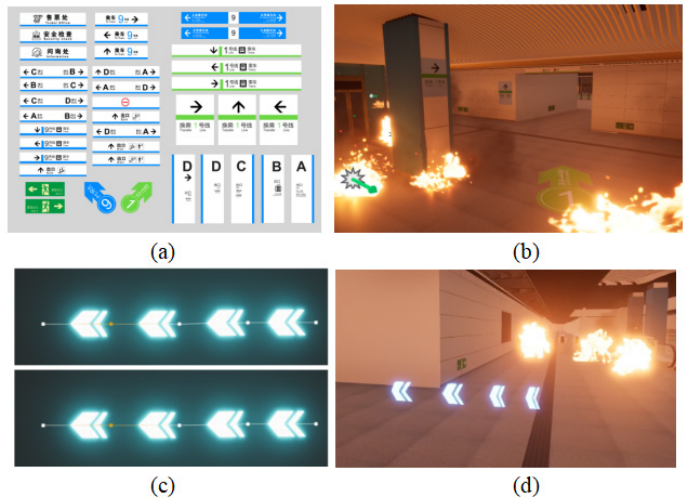
Two wayfinding systems were implemented (see Figure 1), both conveying the same navigational goals, such as exit and transfer directions, while differing in visual presentation and interaction.
The traditional signage adopts static signs, consistent with real metro practice. Information is displayed through suspended or wall-mounted signboards combining text, line numbers, standardized pictograms, and fixed planar arrows (see Figure 1a, b). Directional information was location- bound and required participants to actively search for, interpret, and integrate signage while moving.
In contrast, the virtual signage presents guidance through a series of dynamic virtual arrows embedded in the floor space (see Figure 1c, d). These illuminated arrows formed a continuous directional trajectory aligned with the station layout, emphasized turning points and remained within the participant’s forward field of view. Under fire emergency conditions, the virtual arrows maintain high visibility despite visual disturbances such as flames and reduced lighting, thereby offering more immediate and intuitive evacuation guidance.
By comparing static traditional signage with dynamic virtual arrow guidance, the experiment examines how presentation style influences wayfinding performance, route consistency, and cognitive load under a fire emergency condition.
Figure 1: Signage modes in the VR experiment: (a) designed traditional signage, (b) rendering of the traditional signage in virtual environment, (c) virtual signage, (d) rendering of the virtual signage in virtual environment.
Wayfinding Efficiency of Virtual Versus Traditional Signage 89 Participants
Forty university students (undergraduate and graduate) took part in this experiment and were randomly assigned to one of two between-subject conditions: traditional signage (A2, n = 20, 20% males) or virtual signage (B2, n = 20, 15% males). Each participant completed the experiment under a single condition to avoid learning and carryover effects. All participants reported normal or corrected-to-normal vision, no color vision deficiencies, and no physical or mental conditions that could interfere with their performance in a virtual reality environment. None of the participants reported a history of severe motion sickness that would prevent participation in the VR simulation.
Before the experiment, all participants provided informed consent and received a brief introduction to the VR equipment and interaction procedures. Each received 10 yuan as compensation and was informed that they could withdraw from the experiment at any time without penalty.
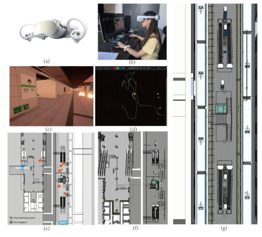
Apparatus and Environment The experiment used a Pico 4 VR headset (see Figure 2), equipped with dual displays (2160 × 2160 pixels per eye) and a 105-degree field of view, to deliver an immersive experience. Experimental scenes were modeled in SketchUp (version 2022) and implemented in Unreal Engine (version 5.5.4), with interactive elements configured via the Pico SDK. To ensure experimental precision and control of variables, the display brightness of the headset was set to its maximum level. Participants’ viewpoints and movements were tracked in real time using Unreal Engine, and the visual output was recorded throughout the experiment.
Figure 2: Experimental scene: (a) Pico 4 VR headset, (b) laboratory setup, (c) participant’s perspective, (d) real-time route tracking map, (e) top view of the scene, (f) top view of the subway F1 level, (g) top view of the subway B1 level.
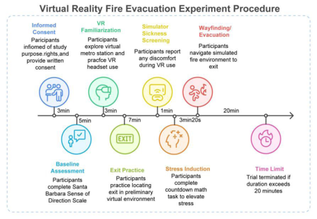
Prior to the experiment, all participants were informed of the purpose and tasks of the study, as well as their right to withdraw from the experiment at any stage, and written informed consent was obtained. Participants then completed the Santa Barbara Sense of Direction Scale (SBSOD) (Cornell et al., 2003) questionnaire to assess their baseline spatial orientation ability.
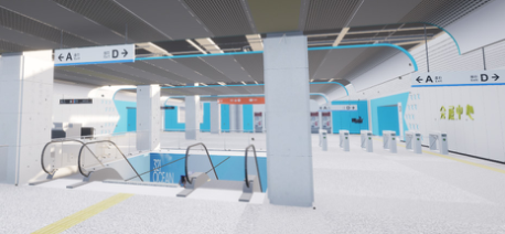
A training phase preceded the formal experiment. Participants first donned the Pico 4 headset for calibration and then entered a preliminary metro station environment (see Figure 3) that differed entirely in layout and content from the experimental scene. They were allowed 3 minutes of free exploration followed by a practice task of locating an exit without time constraints. The training phase familiarized participants with VR interaction, start/end markers, wayfinding signages (consistent with the style they assigned to in the formal task), and task requirements, and served as a simulator sickness screening.
Figure 3: A preliminary metro station environment used for a practice session.
To better reflect the stress level under real fire emergency, a brief arithmetic stress task was administered immediately before the formal trial. Participants completed 20 mixed addition, subtraction, multiplication, and division problems under time pressure. They then completed the evacuation task in their assigned conditions (traditional vs. virtual signage), navigating from a predefined starting point to the designated exit as efficiently as possible within a simulated fire environment. The trail ended when the participant successfully reached the exit Or was terminated at 20 minutes to prevent visual fatigue or simulator sickness.
Figure 4: Virtual reality fire evacuation experiment procedure.
Wayfinding Efficiency of Virtual Versus Traditional Signage 91 Wayfinding Efficiency Indicators
To minimize subjective bias, navigation efficiency was assessed using automatically recorded VR behavior data, and was operationalized through three indicators: (1) Task completion time (in seconds), indexed overall evacuation efficiency, with shorter times indicating more efficient wayfinding. (2) Route length (in meters), captured the economy of path selection and the extent of detours, where shorter distances indicated guidance closer to an optimal route. (3) Offset rate, quantified via Fréchet distance (Teimouri et al., 2023), measured deviation between the actual movement trajectories and the ideal or central path. Lower deviation values indicated fewer pauses, hesitations, and disorientation behaviors during wayfinding. Collectively, these metrics provided a systematic and objective characterization of navigation efficiency, supporting a robust comparison between traditional and virtual signage under emergency conditions.
Data Analysis All statistical analyses were conducted using SPSS to compare wayfinding performance between the traditional signage and virtual signage conditions. Descriptive statistics, including means and standard deviations, were first calculated for all dependent variables.
To examine differences between the two conditions, independent- samples t-tests were performed for each dependent variable. Prior to hypothesis testing, Levene’s test was used to assess the assumption of homogeneity of variances. When this assumption was violated, adjusted t-test results were reported. A significance level of p < .05 was adopted for all statistical tests.
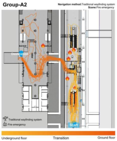
Figure 5 compares navigation paths for the traditional-signage group (A2) and the virtual-signage group (B2) under the fire emergency scenario. In both conditions, participants started from the underground floor, passed through the transition area, and finally reached the safe exit on the ground floor. Overall, under emergency stress, participants’ movement paths tended to be relatively disordered, with most participants detouring around the elevator area.
In the traditional-signage condition (A2), trajectories were more scattered and irregular, with frequent backtracking and pauses, particularly at turning points and stair-staircase interface. Participants spent more time exploring the transition and the ground-floor areas, and some briefly stopped or misnavigated near the fire source. In contrast, the virtual-signage group (B2) demonstrated more concentrated and smoother paths, with most participants following similar routes, avoiding the fire source, and making fewer unnecessary detours, indicating higher wayfinding efficiency and greater path consistency.
RESULTS
Figure 5: Navigation trajectories of participants from traditional (A2) and virtual signage group (B2).
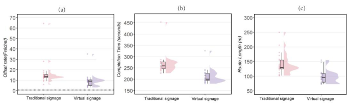
For offset rate, participants using traditional signage exhibited a higher central tendency and greater inter-individual variability, with several extreme values exceeding 60. In contrast, the virtual signage condition yielded a markedly lower median offset rate (approximately 5) and a more compact distribution, indicating more stable and accurate path-following behavior. Inferential statistics confirmed this pattern: the mean deviation rate in the virtual signage condition (M = 9.52, SD = 6.70) was significantly lower than that in the traditional signage condition (M = 16.38, SD = 12.09), t(38) = 2.22, p < .05 (see Tables 1 and 2), suggesting reduced hesitation and navigational disorientation during evacuation.
A similar pattern was observed for task completion time. As shown in Figure 6(b), the traditional signage resulted in a longer median completion time (approximately 250 s) and a wider distribution, with outliers approaching 450 s. By comparison, the virtual signage system reduced the median completion time by roughly 20% (to approximately 200 s) and exhibited less dispersion. Consistent with this distributional trend, the independent- samples t test revealed that participants in the virtual signage condition completed the task significantly faster (M = 98.20 s, SD = 22.52) than those relying on traditional signage (M = 142.10 s, SD = 36.70), t(38) = 4.56, p < .001. This finding indicates a substantial improvement in evacuation efficiency under fire emergency conditions.
Figure 6: Compares the performance of the traditional and the virtual signage condition in (a) offset rate (Fréchet distance), (b) task completion time, and (c) route length.
Wayfinding Efficiency of Virtual Versus Traditional Signage 93 Regarding route length, Figure 6(c) shows that the traditional signage condition was associated with longer paths and pronounced inter-individual differences, with some participants traveling distances of up to 250 m. In contrast, the virtual signage system compressed the median route length to approximately 100 m and reduced overall variability. Statistical analysis confirmed this advantage: the mean travel distance was significantly shorter in the virtual signage condition (M = 212.39 m, SD = 32.52) than in the traditional signage condition (M = 268.59 m, SD = 46.97), t(38) = 4.40, p < .001. This result indicates that virtual signage facilitated more optimal route selection and reduced unnecessary detours.
Table 1: Group statistics of two signage conditions.
Table available in the original PDF paper.
WayfindingSystems N Mean Std. Deviation
Std. Error Mean CompletionTime Traditional signage 20 142.100 36.695 8.205
Virtual navigation system 20 98.200 22.522 5.036 RouteLength Traditional signage 20 268.591 46.970 10.5028
Virtual navigation system 20 212.385 32.516 7.2707 OffsetRate Traditional signage 20 16.382 12.092 2.704
Virtual navigation system 20 9.517 6.701 1.498
Table 2: Independent-samples t test of two signage conditions.
Table available in the original PDF paper.
t-test for Equality of Means Levene’s Test for Equality of Variances
F Sig. t df Sig. (2-tailed)
Mean Difference
Std. Error Difference
95% Confidence Interval of the Difference Lower Upper
94 Zhou and Yang In addition to objective performance measures, subjective evaluations also favored the virtual signage system. Participants reported significantly higher perceived usefulness and greater stress relief under the virtual signage condition compared to the traditional signage condition (both p < .01; see Table 2). These subjective findings align with the objective performance results, suggesting that the virtual signage system was perceived as more supportive and effective in high-stress fire emergency scenarios.
Overall, the combined descriptive and inferential results demonstrate that, under fire emergency conditions, virtual signage significantly outperformed traditional signage by improving evacuation efficiency, shortening travel distance, reducing navigational deviation, and enhancing users’ subjective experience.
DISCUSSION AND CONCLUSION This study employed an immersive virtual reality (VR) fire-evacuation scenario in a metro transfer station to compare the effectiveness of traditional static signage (A2) and virtual arrow-based signage (B2). Wayfinding performance under high-stress conditions was evaluated using task completion time, travel distance, and deviation rate as key indicators of navigation efficiency.
The results indicate that signage type significantly affects evacuation performance. Compared with traditional signage, virtual signage substantially reduced task completion time, shortened travel distance, and minimized deviation, reflecting more efficient and direct navigation. In addition, lower deviation rates suggest reduced hesitation and disorientation during the evacuation process.
These differences can be attributed to the varying levels of perceptual and cognitive support provided by each system under stress. In fire conditions, environmental factors such as smoke, alarms, and heightened arousal likely impair the detection and interpretation of static signage, leading to increased navigation errors. In contrast, virtual signage provides continuous and intuitive guidance, enabling more stable and efficient navigation even in visually disrupted environments.
Overall, the findings demonstrate that virtual signage outperforms traditional signage in enhancing evacuation efficiency, reducing travel distance, and improving navigation stability under emergency conditions. This highlights the strong potential of dynamic guidance systems for improving emergency wayfinding and evacuation safety in complex public environments such as metro stations.
However, several limitations should be acknowledged. The sample size was relatively small and limited to university students, which may affect generalizability. The experiment was conducted in a simulated environment, and stress was experimentally induced rather than arising from real danger. Additionally, the guidance conditions were simplified, focusing on a single virtual-arrow design and a single station layout. Future research should include more diverse participant samples, incorporate more realistic emergency conditions, and explore hybrid guidance systems integrating virtual and traditional signage to enhance real-world applicability.
REFERENCES
Argelaguet, F. (2014). Adaptive navigation for virtual environments. 2014 IEEE Symposium on 3D User Interfaces (3DUI), 123–126. https://doi. org/10.1109/3DUI.2014.7027325 Cornell, E. H., Sorenson, A., & Mio, T. (2003). Human sense of direction and
wayfinding. Annals of the Association of American Geographers, 93(2), 399–425. https://doi.org/10.1111/1467-8306.9302009 Coutrot, A., Schmidt, S., Coutrot, L., Pittman, J., Hong, L., Wiener, J. M., Hölscher, C., Dalton, R. C., Hornberger, M., & Spiers, H. J. (2019). Virtual navigation tested on a mobile app is predictive of real-world wayfinding navigation performance. PLOS One, 14(3), e0213272. https://doi.org/10.1371/journal.pone.0213272 Feng, Y., Duives, D. C., & Hoogendoorn, S. P. (2022). Development and evaluation
of a VR research tool to study wayfinding behaviour in a multi-story building. Safety Science, 147, 105573. https://doi.org/10.1016/j.ssci.2021.105573 Fu, L., Cao, S., Song, W., & Fang, J. (2019). The influence of emergency signage on building evacuation behavior: An experimental study. Fire and Materials, 43(1), 22–33. https://doi.org/10.1002/fam.2665 Jeon, G.-Y., Na, W.-J., Hong, W.-H., & Lee, J.-K. (2019). Influence of design and
installation of emergency exit signs on evacuation speed. Journal of Asian Architecture and Building Engineering, 18(2), 104–111. https://doi.org/10.1080 /13467581.2019.1599897 Lin, J., Cao, L., & Li, N. (2019). Assessing the influence of repeated exposures and mental stress on human wayfinding performance in indoor environments using virtual reality technology. Advanced Engineering Informatics, 39, 53–61. https:// doi.org/10.1016/j.aei.2018.11.007 Lin, J., Cao, L., & Li, N. (2020). How the completeness of spatial knowledge
influences the evacuation behavior of passengers in metro stations: A VR-based experimental study. Automation in Construction, 113, 103136. https://doi. org/10.1016/j.autcon.2020.103136 Motamedi, A., Wang, Z., Yabuki, N., Fukuda, T., & Michikawa, T. (2017). Signage visibility analysis and optimization system using BIM-enabled virtual reality (VR) environments. Advanced Engineering Informatics, 32, 248–262. https://doi. org/10.1016/j.aei.2017.03.005 Peng, F., Zhang, Z., & Ding, Q. (2024, October 1). Analysis of guidance signage
systems from a complex network theory perspective: A case study in subway stations. | EBSCOhost. https://doi.org/10.3390/ijgi13100342 Teimouri, F., Richter, K.-F., & Hochmair, H. H. (2023). Analysis of route choice based on path characteristics using geolife GPS trajectories. Journal of Location Based Services, 17(3), 271–297. https://doi.org/10.1080/17489725.20 23.2229285
LISTED IN THE AHFE DIGITAL BOOKSTORE CATALOGUE
Explore the complete digital volume
Metaverse, Virtual Environments and Game Design
Read this individual research paper free through the original publisher, or explore the full digital proceedings book.
ISBN 978-1-964867-93-9
Explore this ISBN in the AHFE Bookstore ↗Listed in the July 2026 bookstore catalogue; search by ISBN to confirm current availability · Digital book purchase optional