Yao Shi, Xiaozhou Zhou (2025). Evaluating the Effectiveness of Different Directional Signage Systems in Indoor Wayfinding: A Human-Centered Experiment Conducted in Virtual Reality. In: Intelligent Human Systems Integration (IHSI 2025): Integrating People and Intelligent Systems. AHFE Open Access, vol. 160, pp. 351–361. https://doi.org/10.54941/ahfe1005840
The design of wayfinding systems plays a crucial role in shaping both indoor navigation efficiency and the overall spatial experience. Well-designed directional signage not only facilitates the swift and accurate navigation to destinations, minimizing physical fatigue, psychological stress, and frustration due to disorientation, but also plays a vital role in enhancing safety, particularly in emergency situations, by preventing accidents resulting from navigational errors. This is especially critical in complex architectural environments, where the presence of an effective wayfinding system is indispensable. Traditional indoor navigation strategies generally fall into two categories: the first involves grouping destinations and utilizing repetitive signage and arrows to indicate routes, which relies on the user's continuous spatial orientation; the second involves the implementation of continuous guiding paths on floors or walls, often distinguished by varying colors or line styles, designed to reduce cognitive load and minimize directional uncertainty, thereby promoting smoother navigation. Although each of these methods offers distinct advantages and limitations, a systematic comparison of their performance in different environments, especially through the combination of multiple signage types, remains an area that warrants further investigation.This study utilizes immersive virtual reality (VR) technology to simulate virtual environments and assess the efficacy of four distinct wayfinding systems in indoor navigation tasks. The research specifically examines the influence of signage systems on the wayfinding behavior of individuals unfamiliar with a building. Participants were tasked with navigating from the building's entrance to designated rooms under four different signage conditions: wall-mounted signage, ceiling-hanging signage, floor-based continuous guiding signage, and wall-based continuous guiding signage. Key performance metrics, including task success rate, travel distance, completion time, number of pauses, and average movement speed, were recorded and analyzed to evaluate the potential of each signage system in enhancing navigation efficiency.This research not only elucidates the effects of different signage systems on indoor navigation efficiency but also offers empirical evidence to inform the optimization of wayfinding systems in future architectural designs. The findings suggest that by strategically selecting and configuring signage types, the efficiency of navigation in complex or unfamiliar environments can be significantly improved, cognitive load reduced, and valuable insights provided for building design, spatial planning, and emergency evacuation strategies.
Wayfinding refers to the process by which individuals determine and maintain a path from one location to another in space. It encompasses spatial behaviors such as navigation and orientation, which are crucial in daily human activities (Gallistel, 1990). While wayfinding typically proceeds without major issues, individuals often face challenges in complex environments, particularly in densely populated or architecturally intricate settings, leading to disorientation and loss of confidence (Broesamle and Hoelscher, 2007). As urbanization accelerates, cities are expanding, and buildings are becoming increasingly complex. This complexity, particularly in large public facilities such as hospitals (Chen et al., 2021), museums (Lin et al., 2019), and libraries (Mandel, 2018), makes it easy for users
to become lost while searching for destinations, thus negatively affecting their navigation experience and efficiency. Especially in emergency situations, poor building design and inadequate signage systems can pose safety risks, adding stress to individuals in high-pressure environments (Raubal, 2001). Therefore, spatial information plays a critical role in wayfinding. The clarity with which space communicates information impacts the efficiency of route planning and path adjustments during navigation. Furthermore, an efficient spatial information delivery mechanism can significantly reduce anxiety in unfamiliar environments and positively influence wayfinding performance.
When humans navigate unfamiliar environments, they rely primarily on the following methods: directional search, which involves using visual or other sensory information (such as auditory cues or vestibular perception) to identify external markers (such as directional signs on walls) to determine direction and systematically search for a route; following a continuous marked path, which helps reduce cognitive load and uncertainty, guiding travelers along the designated route; and referencing cognitive maps, which utilize internal representations (such as vector maps or topographic maps) to help individuals understand the spatial relationships between locations, thereby facilitating navigation (Allen, 1999).
Directional signage is typically represented with text and arrows, which point toward key locations in a given space and provide users with initial guidance on routes and orientation. This approach can significantly reduce the number of wrong turns and backtracking distances (O’Neill, 1991). While many scholars have conducted extensive research on aspects such as signage color matching (Fu et al., 2019), brightness, and size (Jeo et al., 2019), the exploration of how different spatial positions of signage affect wayfinding efficiency remains limited.
With advancements in immersive technologies, virtual reality (VR) has become a powerful tool for studying wayfinding behavior in controlled yet realistic environments. VR allows researchers to simulate complex indoor spaces, manipulate environmental variables, and collect detailed data on user performance metrics, making it an ideal platform for evaluating signage systems.
On the basis of the above analysis, this study conducts wayfinding experiments in a virtual reality environment to systematically compare the effectiveness of four types of signage systems: wall-mounted signs, ceiling-hanging signs, floor-based continuous guidance, and wall-based continuous guidance. By analysing key performance metrics, this study aims to propose optimization strategies for indoor signage systems, particularly with respect to signage configuration and layout in complex environments. Through VR-based experiments, the effectiveness of these design strategies will be validated, providing valuable insights for future wayfinding system optimization in architectural design. This research aims to increase navigation efficiency, reduce the cognitive load, and improve the user experience in building environments.
Evaluating the Effectiveness of Different Directional Signage Systems 353
EXPERIMENTAL STUDTY We conducted a virtual reality (VR) wayfinding experiment to investigate the impact of different signage systems on participants’ perceptual efficiency. The independent variable in this study is the type of signage system, which includes wall-mounted signs, ceiling-hanging signs, floor-based continuous guidance signs, and wall-based continuous guidance signs. Within the experimental setting, multiple wayfinding tasks with identical paths but different target room functions were designed. The participants were instructed to rely on the signage system to locate the target room. A Unity-based program records key wayfinding performance metrics, including distance travelled, time spent and number of pauses.
Experimental Conditions The four signage systems are organized by destination, grouping and repeating the signage with destination names and pictograms, accompanied by arrows to indicate the correct route to all destinations. The pictograms are selected on the basis of ISO 7001 (ISO, 2007). Each signage category includes clear destination names, corresponding pictograms, and directional arrows indicating the correct path. The design of the signs follows principles of legibility and usability, with different functional areas differentiated by color. The chosen color palette includes rainbow hues, as well as deepened tones of red, orange, and purple, to enhance clarity and visual contrast. Additionally, doorplates matching the signage are placed next to each room, displaying the name of the target room and further reinforcing the consistency of the navigation system and the recognizability of the target rooms.
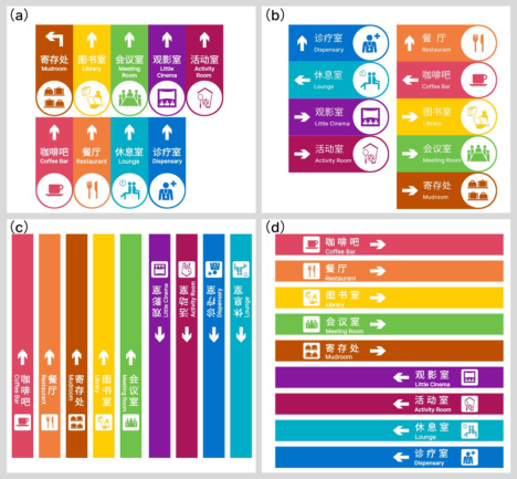
Figure 1: Design of guidance signage in the virtual environment: (a) ceiling-hanging signage, (b) wall-mounted signage, (c) floor-based continuous guiding signage and (d) wall-based continuous guiding signage.
354 Shi and Zhou
The wall-mounted signage system consists of signs installed on the walls of main corridors, intersections, and decision points. These signs group destinations and their directions, helping participants make navigation decisions quickly in complex environments. The signs are approximately 10 cm in height and 25 cm in width (see Figure 1). The ceiling-hung signage system suspends signs from the ceiling in corridors, particularly at intersections and decision points, ensuring that participants can clearly see navigation information from a distance. The signs are approximately 25 cm in height and 10 cm in width (see Figure 1).
The floor-based continuous guidance system consists of continuously colored lines on the floor, with different colors indicating different destinations. The lines are approximately 10 cm wide and extend from the starting point to various target functional areas in the virtual environment, ensuring guidance along the most direct and shortest path (see Figure 1).
The wall-based continuous guidance system uses continuous colored lines fixed to the walls, extending from the starting point to the target rooms and providing navigation along the optimal path. The lines are approximately 10 cm wide, with each color corresponding to a target functional area. These lines are prominently displayed along main corridors and decision points (see Figure 1).
Participants A total of 20 volunteers participated in this study. However, 2 participants were excluded from the sample because they withdrew from the test because of simulator sickness. All the participants who completed the experimental procedures successfully accomplished the wayfinding tasks. The final sample consisted of 18 participants who collectively completed eight wayfinding tasks. These tasks were presented in a randomized order across four different signage conditions. All the participants demonstrated proficient reading and writing skills, normal vision, and no color vision deficiencies. Furthermore, they reported no physical or mental conditions that could interfere with their participation in the VR simulation.
Apparatus and Environment In this experiment, immersive tests were conducted via a Pico 4 virtual reality headset. The Pico 4 is equipped with two panels, each providing a resolution of 2160 × 2160 pixels per eye and a 105
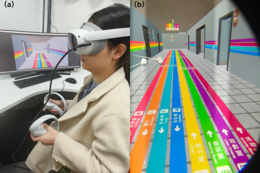
field of view. The device includes built-in controllers that serve as interaction tools. The experimental environment was constructed in Unity 3D, utilizing Unity version 2022.3.42f1, with interactive elements in the scene configured and adjusted via the Pico SDK. To ensure experimental accuracy and control of variables, the device brightness was set to its maximum level, and participants’ perspectives and movements were tracked in real time via the built-in sensors of Pico 4. Figure 2 illustrates the experimental scene from both a third-person and a first-person perspective.
Evaluating the Effectiveness of Different Directional Signage Systems 355
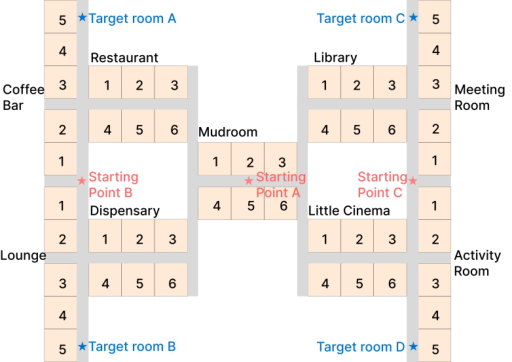
Figure 2: Experimental scene: (a) third-party perspective, (b) participant observation perspective.Figure 3: Scene plan diagram.
All experimental data, including participants’ distance travelled, time spent and number of pauses, were collected and recorded in real time through custom scripts programmed within the Unity environment. The system was capable of tracking and saving each participant’s wayfinding behaviors throughout the experiment. The collected metrics are as follows: (1) Distance, which refers to the travel distance from the starting point to the destination, measured in meters; (2) Time, the time taken to travel from the starting point to the destination within the simulation, recorded in seconds; (3) Pauses, the number of instances where participants remained stationary at the same location for at least 2 seconds (Conroy, 2001).
The experimental scene replicated a typical indoor environment designed to explore participants’ wayfinding efficiency under different signage conditions. A symmetrical and complex building layout was created and
356 Shi and Zhou
divided into nine functional zones, each consisting of five or six rooms, with room dimensions of 5 × 5 meters and corridor widths of 2 meters (see Figure 3). Two path types were established for the experiment. Path Type A included four equivalent routes leading from starting point A to target rooms A, B, C, or D, whereas path Type B included four equivalent routes connecting starting point B to target room C or D and starting point C to target room A or B (see Figure 3).
Procedure Prior to the experiment, the participants were informed of its purpose and tasks, as well as their right to withdraw from the simulation at any time. The experiment commenced with a training phase, during which participants received instructions regarding the experimental procedures and the equipment used. The primary objectives of the training phase were (1) to familiarize participants with the simulated test environment, enabling them to adapt to the setup; (2) to provide practice in using the visual equipment and controllers, ensuring proper handling and operation; and (3) to conduct a preliminary check for symptoms of simulator sickness, where participants were asked to report any discomfort they experienced.
During the training phase, participants were equipped with the Pico 4 device for calibration and adjustment. They were also introduced to the use of controllers. Following this, they entered the test environment to explore the virtual scene and ensure a clear understanding of the experimental tasks and equipment. The participants were encouraged to freely explore the environment and familiarize themselves with the navigation devices as efficiently as possible, with no time constraints. The training phase concluded when the participants were confident in controlling the navigation equipment and reported feeling relaxed or comfortable with the devices.
In the experimental phase, the participants began the formal experiment, completing eight wayfinding tasks. These included navigating from the central functional area’s hallway starting point A to target rooms A, B, C, or D, collectively referred to as Path A, as well as from starting point B to target rooms C or D and from starting point C to target rooms A or B, collectively referred to as Path B (see Figure 1). Path A and Path B will be used throughout the paper to refer to the above-defined navigation routes, and their definitions will not be repeated. The four signage systems were randomly assigned to the various pathway scenarios, and target rooms were identified by door plaques. The experiment concluded when the participants successfully triggered the target room. Additionally, the experiment was terminated if a participant reached the 20-minute time limit in the simulation to prevent eye strain or simulator sickness.
RESULTS
During the experiment, data on participants’ movement distance, number of pauses, and task completion time under different experimental conditions were collected and subjected to statistical analysis. Specifically, the maximum, minimum, mean, and standard deviation of the movement distance, number
Evaluating the Effectiveness of Different Directional Signage Systems 357
of pauses, and completion time were calculated for each signage condition (see Tables 1, 2, and 3), and boxplots were generated to illustrate the data distribution (see Figures 4, 5, and 6). Descriptive statistical analysis of these data revealed performance variations across different experimental conditions, providing a foundation for further analysis. In this study, the experimental conditions were categorized into four types of guiding signage: A = floor-based continuous guiding signage, B = wall-based continuous guiding signage, C = ceiling-hanging signage, and D = wall-mounted signage.
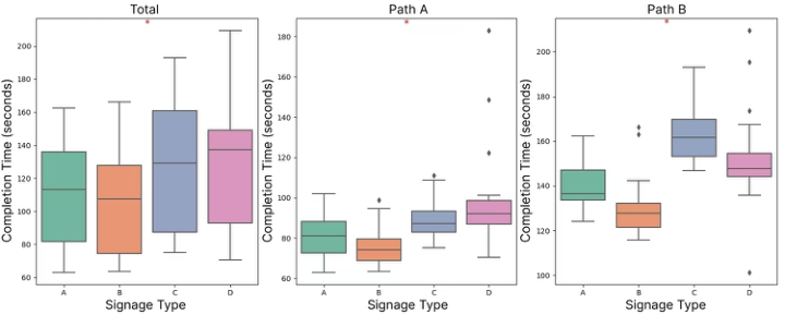
Completion Time The average completion time for Path A was 83.5 s (SD = 15.8 s). Under Condition D, the participants recorded the longest completion time (M = 97.1 s, SD = 19.2 s), whereas those under Condition B had the shortest completion time (M = 72.2 s, SD = 5.7 s). For Path B, the average completion time was 147 s (SD = 16.4 s). The participants in Condition C had the longest average time (M = 160.7 s, SD = 10.0 s), whereas those in Condition B had the shortest time (M = 127.6 s, SD = 8.4 s) (see Table 1).
Table 1. Experimental completion time statistics (in s).
Table available in the original PDF paper.
EC Path A Path B Max Min Mean SD Max Min Mean SD
A 86.5 63.0 74.8 7.1 154.8 124 141.1 10.8 B 80.3 63.4 72.2 5.7 142.4 115.7 127.6 8.4 C 95.3 76.5 87.4 7.2 183.3 149.4 160.7 10.0 D 148.5 80.3 97.1 19.2 173.5 135.7 152.1 12.0 Tot. 148.5 63.0 83.5 15.8 183.3 115.7 147.0 16.4 Note: EC = experimental condition; A = floor-based continuous guiding signage; B = wall-based continuous guiding signage; C = ceiling-hanging signage; D = wall-mounted signage.
Figure 4: Impact of signage type on completion time.
The results of the two-way ANOVA indicated significant main effects of both signage type and path complexity on completion time (P < 0.001), but
358 Shi and Zhou
the interaction effect between signage type and path complexity was not significant (P = 0.016). Among the four signage types, wall-based continuous guiding signage (Condition B) had the shortest median time, making it the most efficient option for reducing pedestrian travel time. In contrast, under the more complex Path B, the ceiling-hanging signage (Condition C) had the longest median time and the widest time distribution, indicating greater variability in completion times (see Figure 4). This could be attributed to the elevated height of ceiling-hanging signage, which may require additional time for some pedestrians to identify the information. To improve the efficiency of ceiling-hanging signage, optimizing its installation height and visibility to minimize the time at which pedestrians need to recognize the information is recommended.
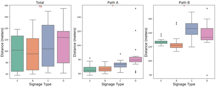
Distance The average movement distance for Path A was 71.8 m (SD = 7.9 m). Under Condition D, the participants travelled the longest distance (M = 80.4 m, SD = 5.6 m), whereas the participants in Condition A travelled the shortest distance (M = 64.1 m, SD = 2.2 m). For Path B, the average movement distance was 133 m (SD = 3.8 m). The participants in Condition C travelled the longest distance (M = 141.6 m, SD = 17 m), whereas those in Condition B travelled the shortest distance (M = 122.7 m, SD = 4.1 m) (see Table 2).
Table 2. Experimental movement distance statistics (in m).
Table available in the original PDF paper.
EC Path A Path B Max Min Mean SD Max Min Mean SD
A 67.2 60.6 64.1 2.2 135.5 123.2 127.2 3.8 B 70.1 61.8 66.0 2.7 131.5 117.9 122.7 4.1 C 78.9 67.0 72.4 3.9 169.6 119.7 141.6 17.0 D 94.0 73.6 80.4 5.6 159.7 126.3 136.2 10.8 Tot. 94.0 60.6 71.8 7.9 169.6 117.9 133.0 13.5 Note: Abbreviations (EC, A, B, C, D) are defined in Table 1.
The results from a two-way ANOVA indicated significant main effects of both signage type and path complexity on movement distance (P < 0.001). Additionally, a significant interaction effect between signage type and path complexity was observed (P = 0.009 < 0.01). Specifically, when the path was more complex (Path B), the movement distance under the ceiling- hanging signage condition was significantly greater than that under the other conditions (P < 0.05). This finding suggests that ceiling-hanging signage is more strongly influenced by path complexity than other signage types are (see Figure 5).
Evaluating the Effectiveness of Different Directional Signage Systems 359
Figure 5: Impact of signage type on distance.
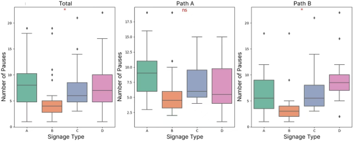
Pause The average number of pauses for Path A was 7.3 (SD = 4.1). Under Condition A, the participants presented the greatest number of pauses (M = 9.1, SD = 4.6), whereas those under Condition B presented the fewest pauses (M = 6, SD = 4.1). For Path B, the average number of pauses was 6.7 (SD = 4.7). The participants under Condition D paused the most (M = 8.8, SD = 4.7), whereas those under Condition B again recorded the fewest pauses (M = 6.7, SD = 4.7) (see Table 3).
Table 3. Experimental pause statistics.
Table available in the original PDF paper.
EC Path A Path B Max Min Mean SD Max Min Mean SD
A 19 3 9.1 4.6 18 1 6.8 4.1 B 19 2 6 4.1 18 1 3.8 3.9 C 15 4 7.2 3.0 21 3 7.4 4.5 D 15 1 7 4.1 22 2 8.8 4.7 Tot. 19 1 7.3 4.1 22 1 6.7 4.7 Note: Abbreviations (EC, A, B, C, D) are defined in Table 1.
The results from the two-way ANOVA indicated a significant main effect of signage type (P = 0.009 < 0.05), while the main effect of path complexity was not significant (P = 0.404 > 0.05), and the interaction effect between signage type and path complexity was also not significant (P = 0.119 > 0.05). With respect to pauses, the floor-based continuous guiding signage had a relatively high median value, suggesting that pedestrians may pause more frequently in the presence of floor signage, potentially because of the need to look down for guidance. In contrast, wall-based continuous guiding signage presented the lowest median number of pauses, making it the most effective signage type for minimizing pauses. Additionally, its distribution range was the smallest, with a narrow interquartile range, indicating superior and consistent performance in reducing pauses (see Figure 6).
360 Shi and Zhou
Figure 6: Impact of signage type on the number of pauses.
CONCLUSION
This study uses immersive virtual reality (VR) technology to simulate a virtual environment and evaluate the effectiveness of four different wayfinding systems in indoor navigation tasks. This research focuses on examining the impact of signage systems on the wayfinding behavior of individuals unfamiliar with buildings. The participants were required to navigate from the building entrance to a designated room under four different signage conditions: wall-mounted signs, ceiling-hung signs, floor-based continuous guide signs, and wall-based continuous guide signs. Key performance indicators, such as distance travelled, time spent and number of pauses, were recorded and analysed. The results indicate that signage type significantly impacts the distance travelled, time spent and number of pauses. Among the four systems, the wall-based continuous guide signage system performed the best, followed by the floor-based continuous guide signage system. Therefore, in environments where minimizing pauses and cognitive load is crucial, such as complex navigation areas or high-efficiency transit spaces, prioritizing wall-based or floor-based continuous signage is recommended.
The limitations of this study include the relatively small sample size, which prevents a conclusive analysis of passenger preferences on the basis of other characteristics, such as gender. Future research could focus on the design of combined signage and the characteristics of design elements (e.g., size, color, and aesthetic combinations) to ensure visual impact while accommodating future changes.
REFERENCES
Allen, G. L. (1999). Spatial abilities, cognitive maps, and wayfinding: Bases for individual differences in spatial cognition and behavior. Wayfinding behavior, 46–80. Brösamle, M., & Hölscher, C. (2007). Architects seeing through the eyes of building
users. Spatial Cognition in Architectural Design. Melbourne, Australia.
Evaluating the Effectiveness of Different Directional Signage Systems 361
Chen, M. S., Ko, Y. T., & Hsieh, W. C. (2021). Exploring the planning and configuration of the hospital wayfinding system by space syntax: A case study of Cheng Ching Hospital, Chung Kang Branch in Taiwan. ISPRS International Journal of Geo-Information, 10(8), 570. Conroy, R. (2001). Spatial navigation in immersive virtual environments. Unpublished doctoral dissertation, University of London. Fu, L., Cao, S., Song, W., & Fang, J. (2019). The influence of emergency signage on
building evacuation behavior: An experimental study. Fire and materials, 43(1), 22–33. Gallistel, C. R. (1990). The organization of learning. The MIT Press. ISO, I. (2007). ISO 7001, Graphical symbols–Public information symbols. Geneva: International Organization of Standardization. Jeon, G. Y., Na, W. J., Hong, W. H., & Lee, J. K. (2019). Influence of design
and installation of emergency exit signs on evacuation speed. Journal of Asian Architecture and Building Engineering, 18(2), 104–111. Lin, J., Cao, L., & Li, N. (2019). Assessing the influence of repeated exposures and mental stress on human wayfinding performance in indoor environments using virtual reality technology. Advanced Engineering Informatics, 39, 53–61. Mandel, L. H. (2018). Understanding and describing users’ wayfinding behavior in
public library facilities. Journal of Librarianship and Information Science, 50(1), 23–33. O’Neill, M. J. (1991). Effects of signage and floor plan configuration on wayfinding accuracy. Environment and behavior, 23(5), 553–574. Raubal, M. (2001). Agent-based simulation of human wayfinding: A perceptual
model for unfamiliar buildings (Doctoral dissertation).
LISTED IN THE AHFE DIGITAL BOOKSTORE CATALOGUE
Explore the complete digital volume
Intelligent Human Systems Integration (IHSI 2025): Integrating People and Intelligent Systems
Read this individual research paper free through the original publisher, or explore the full digital proceedings book.
ISBN 978-1-964867-36-6
Explore this ISBN in the AHFE Bookstore ↗Listed in the July 2026 bookstore catalogue; search by ISBN to confirm current availability · Digital book purchase optional