Jörn Jakobi, Julia Schön, Sara Bagassi, Tommaso Fadda (2026). Presenting ADS-B Labels in a Conventional and in a Remote Virtual Tower Environment: Beneficial or Disruptive?. In: Human Interaction and Emerging Technologies (IHIET-FS 2026): Future Systems and Design Applications. AHFE Open Access, vol. 235, pp. 282–292. https://doi.org/10.54941/ahfe1007282
This study evaluates whether Automatic Dependent Surveillance - Broadcast (ADS-B) information presented as aircraft label tags can enhance air traffic controllers’ situational awareness at conventional aerodrome towers and in remote virtual tower environments, despite the well-known limitations of ADS-B information. The concept leverages augmented reality to superimpose traffic labels onto the conventional out-of-the-window view using a HoloLens 2 headset, and secondly, a fully virtual aerodrome tower environment where the out-of-the-window view is generated by video streams or rendered in a Virtual Reality headset. By relying on an affordable ADS-B receiver, the solution aims to provide a cost-effective way to enhance traffic awareness, particularly at airports with very limited or even without any surveillance infrastructure. Three main research questions are addressed: (1) whether the concept is perceived as beneficial by operators despite the known limitations, (2) the level of user acceptance with respect to content, design, and presentation of the ADS-B label, and (3) operator preferences for head-up and head-down ADS-B label presentation in different equipage and visibility environments. A user-centred passive shadow-mode experiment was conducted with 10 subject-matter experts. Each expert tested the DLR prototype Virtual Tower application in good and low visibility, each experimental run twice with and without the augmented ADS-B label activated using recorded traffic scenarios at Braunschweig-Wolfsburg airport. Results show strong acceptance of the concept, with one expert recommending, and 9 out of 10 strongly recommending it. Very high usability ratings were achieved (average System Usability Scale score of 89), and qualitative feedback confirmed a general appreciation of the interface and the overall concept, further supporting this. Leveraging ADS-B data, especially at airports lacking surveillance, offers a cost-effective means to enhance controllers’ SA and could be implemented in the short term.
Air Traffic Control Officers (ATCOs) are responsible for managing the air traffic at and in the vicinity of an airport. They typically oversee traffic through an Out-of-The-Window (OTW) view to gain necessary surveillance information for traffic management. At larger airports, this is supported by
Presenting ADS-B Labels in a Conventional and in a Remote Virtual 283 various surveillance tools at the Controller Working Position (CWP), such as approach or surface radar and assistance systems for planning, monitoring and alerting. Over the years, particularly at larger airports, the number of tools and interfaces supporting controllers has increased to maintain their Situation Awareness (SA) while improving the safety of operations, despite increasing traffic volumes. However, this working condition often forces the ATCOs to continuously shift their focus between the far OTW view (head-up) and their close-to-view CWP (head-down), which might increase the task load, making it difficult to build up a solid mental traffic picture. Augmented Reality (AR) has been identified as a promising solution to enrich the head-up view with information usually only available head-down. This might help controllers by moving the surveillance information conventionally retrieved from the CWP in their head-up OTW view, thereby reducing the head-up/ head-down gaze shifts.
Augmented Reality in Conventional Aerodrome Control Towers Following this idea, research about AR in the aerodrome control tower started in the early 2000s (Reisman, 2006), with recent projects such as RETINA (Bagassi, 2016 & 2020) and DTT (Bagassi, 2024) – carried out under the SESAR (Single European Sky ATM Research) research partnership – demonstrating the feasibility and benefits of the solution in a simulated environment. Through AR, virtual labels are superimposed on the OTW view, presenting relevant surveillance information tagged to the corresponding aircraft in the head-up position. At the same time, AR can provide other relevant surveillance features (Santarelli, 2022). The concept, assessed through full-scale, real-time, human-in-the-loop simulations involving several experienced air traffic controllers, showed positive outcomes in SA and workload, with a head-mounted display (HMD) solution demonstrating its potential to reduce cognitive effort for the control task (Ellejmi, 2018). Current research focuses on a validated concept for the real world, based on ADS-B surveillance data (Fadda, 2023, 2024). A first prototype has been evaluated at the Bologna control tower with plans to test a more complete platform. ADS-B technology is chosen for the ease of testing and implementation, as the surveillance data are broadcast by the aircraft itself, eliminating the need for an expensive radar facility. On the other hand, a stand-alone ADS-B transponder is not a reliable surveillance source since its equipage is not mandatory1, at least not for smaller aircraft (Maximum Take- Off-Weight < 5700kg), and position reports are assessed onboard, which inherit the uncertainty of their accuracy.
Augmented Reality in Remote Virtual Towers In parallel with conventional aerodrome towers, digitalisation is redefining the entire tower environment, enabling remote control towers in which the OTW view is reproduced remotely via a high-quality, near-real-time
1Regulation (EU) No 1207/2011
video stream from an array of cameras at the airport site (Fürstenau et al., 2022). This can optimise staff resources to provide on-site aerodrome air traffic services (ATS) through the operation of multiple aerodromes from a centralised location, which reduces costs at the end of the day. Similar to conventional towers, AR has been tested in the remote towers (Hagl, 2018; Inoue, 2022), with ease of implementation due to the already digitalised aerodrome panorama view with a fixed point of view. The recent Virtual Tower concept aims to further reduce costs for smaller airports by presenting the aerodrome panorama view and all interfaces virtually through Virtual Reality (VR) goggles (Schön et al., 2023). The solution allows full customisation of the virtual CWP while retaining the surveillance features of a conventional OTW or remote tower. Being entirely virtual, such towers could easily benefit from the same AR solutions tested on the conventional ones. A solution using an affordable ADS-B receiver could create a new cost- effective “augmented radar”, preferably at poorly surveillance-equipped airports. This solution, presented in this paper, could enhance the controller’s SA, though it is unsuitable for surveillance purposes, as a standalone ADS-B sensor does not provide a comprehensive traffic picture.
Case Study and Research Questions The case study presented in this paper concerns the implementation of an ADS-B-based labelling system in a virtual tower application for the Braunschweig-Wolfsburg Airport (BWE), a small airport with a high relative volume of general aviation traffic, which is not consistently equipped with ADS-B transmitters. Thus, the resulting traffic picture allows evaluating the use of a cost-effective sensor, i.e. ADS-B, to increase the ATCO’s SA, even if it does not provide a complete representation of traffic. This condition has not been tested in the conventional tower (Fadda, 2024), where all the aircraft at the selected airport were equipped with ADS-B. Moreover, previous studies considered ADS-B for its accessibility, independent of airport infrastructure, focusing on the AR interface design and assuming future integration of input data with other, more expensive and reliable sources such as SSR, MLAT, and surveillance systems like A-SMGCS.
Hence, in this pilot study, the perceived usability of ADSB–fed AR labels was assessed in two distinct environments: I. Virtual Tower – pre-recorded traffic scenarios with varying visibility
conditions, shown via Meta Quest VR headsets. II. AR OTW Tower – observing live traffic at BWE airport, augmented with ADS-B label through a HoloLens headset.
To evaluate the effectiveness of the concept, three research questions are assessed in a user-centred study involving 10 subject-matter experts. Firstly, the study examines whether the concept is useful or beneficial for operators, despite only ADS-B equipped traffic being label-tagged. Secondly, it assesses whether the controllers approve the interface’s general design, usability, and effectiveness. A third question concerns the preferred ranking of four different AR implementation levels under good and low visibility conditions, both in conventional and VR environments.
Presenting ADS-B Labels in a Conventional and in a Remote Virtual 285 Setup of Augmented ADS-B Label in a Virtual Tower Environment
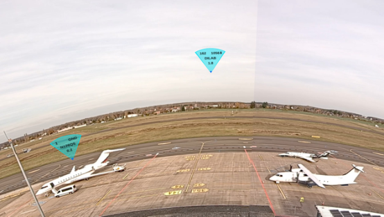
The virtual tower testing application, running on the Meta Quest 3 device, consists of a 360° panoramic live stream of the BWE airport. The device speakers reproduce a live feed of air traffic control communication between the real BWE tower and the pilots. For the ADS-B labels, the aircraft’s GPS coordinates, sent over ADS-B, are converted to a Cartesian coordinate system through a calibration process that accounts for the camera’s projection matrix, and the labels are displayed on the camera’s screen view where each aircraft appears. Each label is a triangle placed over the aircraft, pointing downward. It is semi-transparent to reduce visual clutter in the scene.
Figure 1: BWE Airport view inside the virtual tower app with labels. Label dimension decreases with distance, with speed and altitude disappearing over 5nm.
The surveillance information on the label includes the aircraft callsign in the centre; the distance in nautical miles (nm) from the airport reference point (ARP) at the bottom; and, in the top row, the aircraft’s speed and altitude, which disappear when the aircraft’s distance from the ARP is larger than 5 nm. The whole label shrinks as this distance increases and disappears beyond 10 nm. The labels are rendered in depth, coherently with distance from the ARP, ensuring that the label in front is readable and the background remains visible. Fig. 1 showcases some elements of the label’s design.
ADS-B data are provided from the DLR-owned jetvision (2010) surveillance system, and all ADS-B transmitting aircraft within the 10 nm range are labelled. Incoming and outgoing traffic is not distinguished. For the validation campaign, the application has been adapted to reproduce recorded data (synchronised video, audio, and ADS-B data streams), allowing the selection of two significant scenarios for normal and low-visibility conditions to be presented to all the controllers during the study.
Setup of Augmented ADS-B Label in a Conventional OTW Tower The adopted ADS-B-based AR application for the conventional tower was prototyped by the University of Bologna (Fadda, 2024) and adapted for
BWE. The platform uses a HoloLens 2 see-through device to augment a direct OTW of the airport. Only minor adjustments are needed to register the AR overlay in the new scenario. Since live traffic is not always present, some videos are recorded in advance and shown to controllers when needed to demonstrate the application’s behaviour.
METHODS
Participants The study involved 10 participants, comprising five Air Traffic Control Officers (ATCOs) and five Aerodrome Flight Information Service Officers (AFISOs) from different German airports. Their ages ranged from 22 to 62 years (M = 47.9, SD = 14.9), and their professional experience ranged from 1 to 38 years, with an average of 15 years (SD = 12.9). All participants were male.
Experimental Design To examine ATCOs’/AFISOs’ overall attitudes toward the usefulness and usability of ADS-B labels, as well as their preferred design choices, this study employed post-exercise responses to items of a structured questionnaire that included both closed- and open-ended items with respect to usability, to their perceived SA, to their preferred design options, content of the label, ranking of presenting ADS-B Label in different contexts (virtual versus conventional tower and under varying visibility conditions), and finally, to their estimate of the maximum wearing duration of the HoloLens or Meta Quest headsets. Furthermore, participants were encouraged to give their spontaneous remarks while observing the label in passive shadow mode using the think-aloud technique, and further by post-exercise free-text comments in the questionnaire.
RESULTS
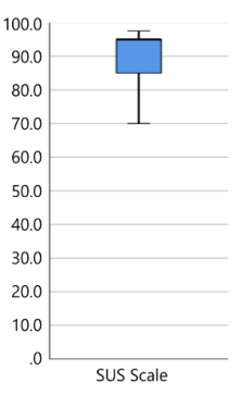
Usability To assess overall usability, the study used the System Usability Scale (SUS; Brooke, 1996), a widely validated instrument. Because this investigation focused on the usability of the ADS-B label, the generic term “system” in the SUS items was replaced with “label.” A German version of the SUS, adapted by Rummel (2016), was administered. The SUS produces a single score on a 0 - 100 scale, with higher values indicating greater perceived usability. Participants judged the ADS-B label’s usability with a SUS mean score of 89.25 (SD = 9.2) and a median of 95.0. A SUS mean score exceeding 90, according to Brooks categories (1996), indicates exceptionally high usability—akin to a “wow” effect. Figure 2 illustrates the median value of 95 with its 50 % inter-quartile box ranging from 83.2 to 95.0, and whiskers indicating the minimum and maximum scores.
With respect to the general perceived usefulness of ADS-B label, the ATCOs/AFISOs were further asked: “Would you prefer to see labels on equipped aircraft, even if you know that unequipped aircraft have no labels
Presenting ADS-B Labels in a Conventional and in a Remote Virtual 287 and might be overlooked?” with answer options from 1 = Strongly disagree, 2 = Disagree, 3 = Neutral, 4 = Agree and 5 = Strongly agree. Except for one, who answered with 4, all the other nine participants answered with 5 (M = 4.9, SD = 0.3). Furthermore, the following usability and design questions were asked with 1 = Strongly disagree till 5 = Strongly agree (see Table 1).
Figure 2: SUS boxplot diagram.Table 1: Usability and design questions.
Table available in the original PDF paper.
Median Min Max The use of ADS-B labels would generally confuse me rather than help me. 2.0 1 2
I would like the option to turn all ADS-B labels on or off as needed. 4.5 4 5 I would like the option to selectively hide only the ADS-B labels of the aircraft on the ground. 3.0 2 5
I would appreciate the ability to show and hide the edges of the runway. 4.0 2 5 I like that the a/c located at a distance of > 5 nm have a reduced label (smaller, only showing call sign and distance to ARP). 5.0 1 5
I like that labels of aircraft located at a distance > 10 nm are suppressed. 3.0 1 5
Situation Awareness To explore the effect of the ADS-B label augmentations on the operators’ SA, Endsley’s (1995) three-level model was used, with tailored questions addressing each level. Endsley’s model defines SA as (1) Perception - the real-time acquisition of environmental information; (2) Comprehension - the interpretation of those perceptions to form an understanding of the system’s state; and (3) Projection - the anticipation of future events based on that understanding, enabling proactive decision-making. Results are shown in Table 2.
Table 2: Situation awareness with and without ADS-B label.
Table available in the original PDF paper.
Endsley’s Levels I-III Median Min Max I) Perception without Without a label, I had a good overview of the current traffic situation at the airport. 2.0 1 4
I) Perception with
With the label, I had a good overview of the current traffic situation at the airport. 5.0 3 5 IIa) Compreh. without
2.0 1 5
Without a label, I was able to fully understand what was happening at the airport and in the airspace.
IIa) Compreh. with
5.0 4 5
With the label, I was able to fully understand what was happening at the airport and in the airspace.
IIb) Compreh. without
Without the label, I knew exactly where each aircraft was located. 2.0 1 4 IIb) Compreh. with With the label, I knew exactly where each aircraft was located. 5.0 4 5
III) Projection without
Without a label, I could foresee how air traffic would develop. 2.5 1 5 III) Projection with With labels, I could predict how air traffic would develop. 4.0 4 5
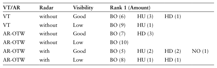
Ranking of Preferred ADS-B Label Presentation This question aimed to rank four different presentation modes: ADS-B label on a head-down traffic situation display (HD), ADS-B label augmented in the head-up view (via the headsets) (HU), both head-up and head-down (BO), and no ADS-B label presentation at all (NO). These four possibilities were asked to rank them for two different environments: Virtual Tower (VT) and AR OTW Tower (AR-OTW), both under good vs. low visibility and additionally in a conventional tower environment with and without any other surveillance sensor (approach radar). Table 3 presents the total number of preferred options ranked first. The combined head-up/head-down label display (BO) consistently emerged always as the top choice under all conditions (see Table 3).
Table 3: Rank 1 choices of ADS-B label presentation in different environments.
Presenting ADS-B Labels in a Conventional and in a Remote Virtual 289 Design Feedback
Three design-related questions were posed regarding the ADSB label size, overlap behaviour and text size. Each question received a median rating of 4 on a 5-point Likert scale, indicating good acceptance while yielding actionable suggestions for refinement (see Table 4).
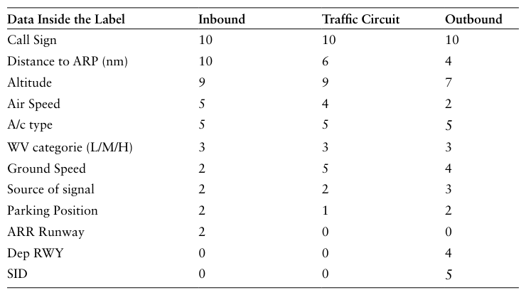
Preferred Data Inside the Label Label tags offer only limited space and cannot display all ADS-B-derived flight data; therefore, participants were asked to choose data they wished to see during inbound, traffic circuit, and outbound operations from a list. Table 5 shows unanimous agreement across all flight phases that the callsign is the primary parameter, followed by distance to the Airport Reference Point (ARP), altitude, speed, and aircraft type.
Table 4: Design feedback with respect to labels’ size and overlap behaviour.
Median Min Max The general size, shape and colour representation of the labels fully meet my requirements. 4.0 2 5
I find it intuitive that labels near me cover those further away, ensuring readability of the closer a/c’s label for navigation. 4.0 2 5 The text information in the labels is generally very easy to read. 4.0 4 5
Table 5: Amount of participants’ choice of preferred data inside the label.
Table available in the original PDF paper.
Estimated Maximum Wearing Duration At the end of the questionnaire, participants were asked how long they could comfortably wear each headset. They chose from four response options: up to 10, 30, 60 minutes (min) or even longer. This provides a simple, ordinal measure of perceived wearing comfort for each device. Except for one, all
participants felt at least comfortable with up to 30 min for both devices. Five of 10 participants could imagine up to 60 min for both devices, and some of them even longer (see Table 6).
Table 6: Number of participants for each max. Wearing duration for both headset devices.
Summary of Participants Comments Participants were encouraged to give feedback through think-aloud comments during the trials and post-hoc questions with comment functions. These comments were used to gain further insight into the perceived advantages and disadvantages of ADS-B label integration, its presentation mode, and the overall design. All 10 participants highlighted several positive aspects of using ADSB labels as an additional information source for air traffic services. Almost all participants noted that integrating ADS-B labels would lead to a clearer overview of traffic, stating an enhanced mental image of the traffic, quicker localisation of aircraft and traffic hotspots, as well as improvements in overall visibility, especially in low-visibility weather conditions. Additionally, participants noted that by displaying key surveillance parameters, the labels provided “more information at a glance”. Overall, participants felt that the ADS-B labels enhance spatial awareness, support better information representation, and act as a useful auxiliary tool, providing at least some useful data even when conventional OTW or radar coverage is lacking.
Participants also voiced concerns and suggested improvements. The absence of labels for unequipped aircraft could lead to an inaccurate mental model. Other respondents noted that the system is “good enough” as long as they pay close attention. Participants flagged clutter when traffic density is high, arguing that the many overlapping labels could obscure the view rather than clarify it. Possibly the colour scheme should be adjustable: different colours for arrivals, overflights, and departures.
DISCUSSION AND CONCLUSIONS The study was designed to examine whether displaying ADSB labels (as a low- cost, radar-like surveillance supplement) could enhance ATCOs/AFISOs’ SA in a conventional Tower as well as in a remote Virtual Tower environment, even though ADSB alone does not provide a reliable surveillance solution. State-of-the-art surveillance systems such as A-SMGCS have demonstrated that ATCOs insist on highly reliable surveillance information (Jakobi, 2007). If it is not trustworthy, the information should preferably be omitted rather than displayed incorrectly (EUROCAE, 2022). Accordingly, it was anticipated that ATCOs/AFISOs would reject ADS-B labels as a radarequivalent data source rather than accept them. Contrary to this assumption, all ten
Presenting ADS-B Labels in a Conventional and in a Remote Virtual 291 participants expressed an agreed willingness to be presented with ADS-B data, acknowledging its limitations, both in a conventional OTW as well as in a Virtual Tower environment. In practice, only aircraft equipped with an ADS-B transponder that is actively transmitting are visible, and equipage is not mandated for all aircraft, resulting in unknown coverage gaps. Moreover, position reports may be less accurate as they rely on the aircraft’s own navigation system. Participants were briefed on these caveats before the trial. Nonetheless, they appeared to conclude that, before having no or insufficient data on an aircraft’s ID and position, it is preferable to have ADS-B information available. This allows ATC/AFIS officers to survey the traffic more easily, whether in an OTW or a Virtual Tower environment, and to obtain supplementary flight status data such as distance to the ARP or current altitude, which cannot be readily inferred from OTW or camera sensors alone. This unexpected consensus offers compelling evidence for adopting ADS-B as a promising surveillance gapfiller supplement, especially in tower environments where, beyond visual or panoramic camera feeds, no additional surveillance means exist.
Given the markedly lower cost of an ADS-B solution relative to costly surveillance systems like Radar or MLAT, the logical conclusion of this study is that ADS-B should be implemented and considered a viable monitoring aid for aerodrome air traffic services particularly in environments without any supporting surveillance systems.
ACKNOWLEDGMENT
The last author’s PhD scholarship is financed by NextGenerationEU through the Italian Ministry of University and Research scholarship under the Italian NRRP Investment M4C1-I.4.1 PNRR research - CUP J33C2300268000.
REFERENCES
Bagassi, S., Corsi, M., De Crescenzio, F., Santarelli, R., Simonetti, A., Moens, L., & Terenzi, M. (2024). “Virtual/augmented reality-based human–machine interface and interaction modes in airport control towers” in Scientific Reports, 14(1), 13579. Bagassi, S., De Crescenzio, F., Piastra, S., Persiani, C. A., Ellejmi, M., Groskreutz, A. R.,
& Higuera, J. (2020). “Human-in-the-loop evaluation of an augmented reality based interface for the airport control tower” in Computers in Industry, 123, 103291. Bagassi S., De Crescenzio F., Lucchi F., Masotti N. (2016). “Augmented and virtual reality in the airport control tower”. 30th Congress of the ICAS 2016. Brooke, J. (1996). “SUS: a ‘quick and dirty’ usability scale” in P.W.Jordan, B. Thomas,
B.A. Weerdmeester, and I.L. McClelland (Eds.) Usability Evaluation in Industry (pp. 189–194). Taylor and Francis. CANSO (2021). “Guidance material for remote and digital towers.” https://canso.
fra1.digitaloceanspaces.com/uploads/2021/04/canso_guidance_material_for_ remote_and_digital_towers.pdf Ellejmi, M., Bagassi, S., and Persiani, A. (2018). “Evaluation of augmented reality tools for the provision of tower air traffic control using an ecological interface design” in 2018 Modeling and Simulation Technologies Conference, p. 2939. Endsley, M. R. (1995). “Toward a Theory of Situation Awareness in Dynamic
Systems”. Human Factors, 37(1), 32–64. doi:10.1518/001872095779023019
EUROCAE, (2022). MASPS for A-SMGCS including Airport Safety Support Service Routing Service and Guidance Service (ED-87E). Fadda, T. (2024). “A roadmap for the implementation of augmented reality solutions
for airport control towers in an operative environment” in Materials Research Proceedings, 42, pp. 173–177. Fadda, T., Bagassi, S., and Corsi, M. (2023). “ADS-B driven implementation of an augmented reality airport control tower platform” in Materials Research Proceedings, 37, pp. 767–770. Fürstenau, N., Jakobi, J., Papenfuss, A. (2022). “Introduction: Basics, History, and
Overview”. In: Fürstenau, N. (eds) Virtual and Remote Control Tower. Research Topics in Aerospace. Springer, Cham. https://doi.org/10.1007/978-3-030-93650-1_1 Hagl, M., Friedrich, M., Papenfuss, A., Scherer-Negenborn, N., Jakobi, J., Rambau, T., and Schmidt, M. (2018). “Augmented reality in a remote tower environment based on VS/IR fusion and optical tracking”. In International Conference on Engineering Psychology and Cognitive Ergonomics (pp. 558–571). Cham: Springer International Publishing. Inoue, S., Brown, M., & Kakubari, Y. (2022). “Integration of (Surveillance)
Multilateration Sensor Data into a Remote Tower System” in Virtual and Remote Control Tower: Research, Design, Development, Validation, and Implementation (pp. 167–196). Cham: Springer International Publishing. Jakobi J., Teutsch J., (2007). “A-SMGCS Verification and Validation Results from the Project EMMA (level 1&2)”, Proceedings of the 7th USA/Europe Air Traffic Management Research and Development Seminar, ATM 2007, pp. 164–174. jetvision® is a brand of the Günter Köllner Embedded Development GmbH, 2010.
https://jetvision.de Pinska. E. (2006). “An investigation of the head-up time at tower and ground control positions”. Proceeding of the 5th Eurocontrol Innovative Research WS, pp. 81–86. Reisman, R., and Brown, D. (2006) “Design of augmented reality tools for air traffic
control towers” in 6th AIAA aviation technology, integration and operations conference (ATIO). p. 7713. Santarelli, R., Bagassi, S., Corsi, M., Teutsch, J., Lasheras, R. G., Carmona, M. A. A., & Groskreutz, A. R. (2022). “Towards a digital control tower: the use of augmented reality tools to innovate interaction modes” in SESAR innovation days, 2022. Schön, J., Thielmann, L., Nadobnik, A., Rambau, T., and Jakobi, J. (2025).
“Prototyping and Evaluation of a Virtual Tower Work Station” in Transportation Research Procedia, 88, 193–200.
LISTED IN THE AHFE DIGITAL BOOKSTORE CATALOGUE
Explore the complete digital volume
Human Interaction and Emerging Technologies (IHIET-FS 2026): Future Systems and Design Applications
Read this individual research paper free through the original publisher, or explore the full digital proceedings book.
ISBN 979-8-950676-11-6
Explore this ISBN in the AHFE Bookstore ↗Listed in the July 2026 bookstore catalogue; search by ISBN to confirm current availability · Digital book purchase optional