Robert Masztalski, Marcin Michalski (2018). The Human Factor in the Urbanism of Medium-Sized Cities in Poland. In: Advances in Human Factors and Sustainable Infrastructure. AHFE Open Access, vol. 3. https://doi.org/10.54941/ahfe100109
Poland has a very extensive network of cities. The nature, scale and adaptation to the needs of residents weigh their future fate. Some cities are already recognizing this problem and try to involve in urban development plan also the human factor. Such actions are not only public participation in shaping the directions of development of the city as a whole but also participation in the creation of various public spaces.
Leszno is a good developing medium-sized town, halfway between Wroclaw and Poznan. Taking care of proper development of spatial policy is one of the fundamental tasks of local government. As a part of these activities should be implemented so-called "city own task" in terms of shaping the spatial order and sustainable development, but also initiate the social debate on the strategy of spatial development of the city in the form released from the rigid framework of existing legislation. Many local authorities don't implement such actions assuming, that activities not required by law are a wast of time and money. Nothing could be further from the truth. Any form which activates the local community will result in even greater degree of identification with the city. Controlled by the city the urban planning processes, require complex rules that govern its life to ensure optimum coexistence of conflicting interests of individual residents and enterprises with social requirements, aimed at the common good in a spirit of ergonomics.
This is a slow and difficult process of adjusting control systems to changing circumstances, especially when strategic thinking is not yet the norm and bureaucracy organizations often permeates the city organizations, preventing the use of endogenous creative potential. Managers limited by legal regulations, are often not able to use their creative talent, so they look for new forms of the city management, in order to circumvent restrictions and encourage innovation and activity. To think and act strategically, municipalities frequently are being forced to limit their activities, and reject many activities important from the point of view of ergonomics in urban planning but less important at the given moment. This concerns even the availability of important points of the city by walking and cycling, but also the possibility of appropriate recreation and leisure for its residents.
Similarly as the well-designed kitchen allows optimal and secure utilization, also properly well designed housing estate increases the level of its usefulness and safety. Thus, measures of local government, including the adjustment of the shape of the material environment to the psychophysiological needs and capabilities of its inhabitants are useful and desirable. In this matter, targets of urban design and ergonomics are converging.
THE URBAN DEVELOPMENT OF LESZNO Leszno till 31st December 1998 was one of the 49 voivodeship capitals in Poland and after 1st January 1999, it became one of the larger medium-sized cities in Poland1. There is so many of those cities, that their chances for strong urban development decreased significantly. Opportunities connected with being the capital of the voivodeship, generated a lot of support for the development process of the city. After losing those extra opportunities Leszno became an ordinary medium-sized town in the Polish settlement network. The medium-sized cities such as Leszno, must have a high proportion of exogenous function in its structure. Most frequently it's related to the fact of exceeding a certain threshold of cost-effectiveness of certain types of business by the city as a result of the impact on the much broader scale than its administrative boundaries.
1 These cities, with a population from 50 to 100 thousand inhabitants, in addition of Leszno: Biala Podlaska (57978 inhabitants ) , Chelm (67324 inhabitants ), Ciechanow (57978 inhabitants ), Jelenia Gora (84023 inhabitants ), Kalisz, Konin (79212 inhabitants ), Krosno (47471 inhabitants), Lomza (63221 inhabitants), Nowy Sacz (84537 inhabitants) Ostroleka (53710 inhabitants) Pila (74550 inhabitants), Piotrkow Trybunalski (77383 inhabitants), Plock (57978 inhabitants), Przemysl (66229 inhabitants ), Siedlce (77392 inhabitants), Skierniewice (49044 inhabitants), Slupsk (96655 inhabitants), Suwalki (69527 inhabitants), Zamosc (66234 inhabitants ) – demographic data of Central Statistical Office of Poland, as at December 31, 2010 Sustainable Infrastructure (2018)
Figure 1. The urban structure of Leszno (own)
Figure available in the original PDF paper.
The urban development of Leszno, took place so far without significant perturbations. By the end of the 80s of twentieth century was dominated by residential development, realized in prefabricated technology. New residential multi-family housing was built on the east side of the downtown area. In contrast, single-family residential development was developed in both the eastern and western part of the city. In the 90s of twentieth century, spatial expansion started with the single-family residential development in the northern part of the city in the district Gronowo. Today, it is almost fully built-up area of the city with all the necessary district services. Urban structure of the city is composed of a central part containing the oldest, historic part of the city and nineteenth century residential and service buildings,. This area of town is closely associated with the downtown area and is the oldest part of the city. This zone, is located between the railway and the course route of national road No. 5 relation Wroclaw-Poznan. In this zone were realized several, earliest post-war, multi-family housing, including prefabricated housing. Area to the west of the railway line relation Poznan-Wschowa was built up with single-family residential neighborhoods. In this zone there is also a sport airport. There is also large number of companies and service agencies. The zone to east from the route of national road No. 5 relation Wroclaw-Poznan was built up with multi-family prefabricated housing estates and also by single-family residential units. Here is comprehensively designed and built by a team of architects Fikus & Gorawski in the 80s of twentieth century estate Grzybowo. This part of town was a subject to the greatest changes in recent years. The north zone associated with the district Gronowo is experiencing its largest growth since the early 90s of the twentieth century. This part of town has a mixed building development, which consists of single-family housing units and small multi-family housing. The southern zone, cut by the railway line relation Poznan-Wroclaw, is divided into two areas. The first in the south-eastern part of the city consists of a citywide services, at the inlet of the national road 5 to Leszno and district Zaborowo, incorporated in the city limits in 1977. The second, is the undeveloped area between the railway lines relation Poznan-Wroclaw and Poznan- Wschowa. In this part of town are located allotment gardens.
The general plan and a set of detailed plans from the 80s Twentieth century, was ensuring the right tools for rational spatial policy. The entry into force of the 1994 Act caused minor damage in the urban development of the city, because the development of planning made before the 1994 year remain in force. It ensured the continuation of settlement processes, and further urbanization of the city, also supported by the fact that Leszno was one of the 49 capitals of voivodeship. Even introduction a mechanism of the conditions for the development, beyond the findings of the Local Spatial Development Plan, only slightly damaged the urban situation of the city.
ERGONOMICS IN URBAN PLANNING Assuming that “ergonomics or human factor are determining relations arising between man and his activity, equipment and the environment in the broadest sense, including situations related to work, fun and games, recreations and traveling (Kowal, 2002, p.23), the urban planning should create an environment, which uses such technical and technological solutions, for human functioning in urban areas, that it will be for him beneficiary in various aspects of his life.
Whichever definition of ergonomics2 we adapt, conclusion is, that it is an interdisciplinary science, which priority is to generally understand a human good in material and immaterial terms, both at the micro levels (objects of daily use) and macro levels (architecture of building, planning and land development space). Not only the functional, aesthetic and usable quality of space element has an effect on people but also his location in the space and influence 2 „Ergonomics (or human factors) is the scientific discipline concerned with the understanding of interactions among humans and other elements of a system, and the profession that applies theory, principles, data and methods to design in order to optimize human well-being and overall system performance. Ergonomists contribute to the design and evaluation of tasks, jobs, products, environments and systems in order to make them compatible with the needs, abilities and limitations of people.” ( source: IEA, www.iea.cc) Sustainable Infrastructure (2018) on individuals or groups of people. Both, the physical and psychological comfort of individuals and groups are mutually dependent. It is not enough to put a man in comfortable and ergonomically designed chair, at the same time closing him in the space delimited by the walls (barriers), causing psychological discomfort, or potentiating fears. Similarly, in urban planning, the organization of functional, aesthetic or usable space, should take into account its anthropogenic nature, where man live and work, and which is shaped by him, and which on the rules of speed feedback, acts on him.
Looking at the contemporary shaped urban space, and the determined economic factor with its consumerist character, it can be concluded that the quality of the space and the elements which create it, leave a lot to be desired. Designing of urban planning, seem to be tightened by economic calculations, focused on aesthetics and "plain visual impact", whith a lesser degree on functionality, showing that not only the norms of social life, but thoughts and ideas aimed at improving the living conditions, in terms of ergonomics, are increasingly being marginalized (Bonnenberg, 2012, p.11-18). Civilizational development, which we can now identify with the Internet, virtual world, and advanced technologies has its influence, so much alarming if not devastating, and devastating if it speaks for profit on the expense of a negative impact on the society. Migration of population inside the cities, resulting from implementation of needs and duties of vocational life their citizens, are the factor, that verifies the functionality of the spatial structure. For example: if the communication infrastructure solutions satisfy its role in timing of traffic in the city, or whether the method of spatial planning generates or minimizes the functional barriers in urban planning.
Urban planning aims to coordinate the various functional elements of the space, by using different treatments organizing this urban space (eg zoning) by equipping in the technical and technological elements that affect the functioning. Important, from the point of view of the spatial organization and functioning in the larger scale, is communication, which should satisfy the needs of transportation or parking spaces, generally related to migration in the city. Methods of communication solutions in urban design, can be several, depending on the circumstances and traffic type that they pursue (eg, vehicular traffic, pedestrian). It should be taken into account that requirements related to functioning of the urban space which need access to roads, supplies, technical economic and emergency solutions, and these influence the system of communication. (Korzeniewski, 1989, p.216-236)
Figure 1. View of the railway station and bus station in Leszno (source: www.leszno.pl) At the example of the Leszno city, attempt was made to solve the problem of communication, improving the functioning of the downtown, where exist some conflicts of functional and other spatial barriers, resulting from traffic system and migration in the city. Leszno with a population of close to 65 thousand, and taking into account the extra influx of people related to the city as a place of work, study, etc., faces a dilemma of functional solutions, including the migration inside the city, with a significant barrier which is urban railway Wroclaw, Poznan dividing the city into two halves.
Figure available in the original PDF paper.
The current possibilities of movement are limited by many barriers. In the area of the railway station, such barrier is the need to pass by railroad tracks, which with closed railway gates is possible only by a narrow underground passage in Słowianska street leading directly to the market. Another barriers are the passages through the main communication routes of the city, eg. Przemyslowa, Krasinskiego and Mickiewicza street, and "illegal" passages through lands owned by the various public and private institutions. The movement of tourist traffic is mixed here with the movement of commuting to schools and universities, as well as the movement of commuters to Leszno.
On the basis of analyzes and studies it was found that to the secondary schools and universities, concentrated in this area of the city (downtown) daily commute about 3250 students.This is a significant number, which in hours of the morning and afternoon peaks, requires fast and collision-free movement between schools, the railway station and the bus stations. The situation needs to be repaired, by creating the conditions for safe and collision-free, easy and fast communication from the region of railway and bus stations to school buildings in the city center.Analysis and studies have shown that the most urgent investment is creating a new collision-free passage through the railroad tracks (see Figure 3). This crossing is the shortest way connecting the railway station and the bus station enabling the safe connection with the railway station, and this part of town with education facilities.In the analyzed solutions, it seems more reasonable to create overground pedestrian crossing , over the railway line . The rest of the track should utilize the land which is owned by the state, and municipalities for the delineation of a new, appropriately broad main traffic route.
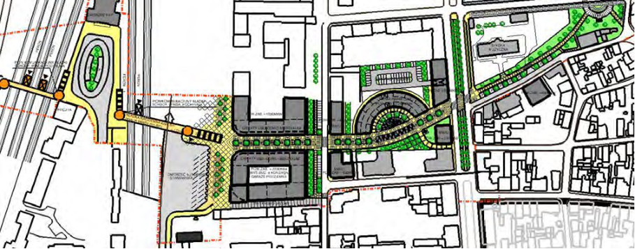
Figure 3. The concept of " school route " in Leszno. (own)
Executing of school route, which is a new thoroughfare of the city, would enables relatively easy access to key facilities of secondary and higher education in the area of the city center. It could help to highlight the important role, played by the secondary and higher education, related to activation program which is currently implemented in Leszno. The concept of connecting the railway station and bus station in Leszno, with secondary and higher education objects creates a new route for pedestrians in the city (see Figure 3) The aim of this project was to combine the important places in the city, related to internal migration between objects that generate traffic: the main railway station and bus station , and secondary and higher education objects. While executing the idea and taking into account the needs and safety of the users, was decided to create a walking route (as priority traffic), with admission of its local traffic, service and residential function. In this concept it was decided that over the railway as a specific barrier of urban planning, footbridge would be realized, supported by using lifts and ramps, for people with the limited ability to move (eg. people with disabilities). Implementation of the footbridge, seems only reasonable solution, taking into account aspects of security and ensuring communication. In opposite to the underground tunnel, footbridge is a subject to a constant social control. Traffic on it is visible from all sides, and from the point of view of a sense of personal safety, it should be considered as the better solution then pedestrian tunnel.
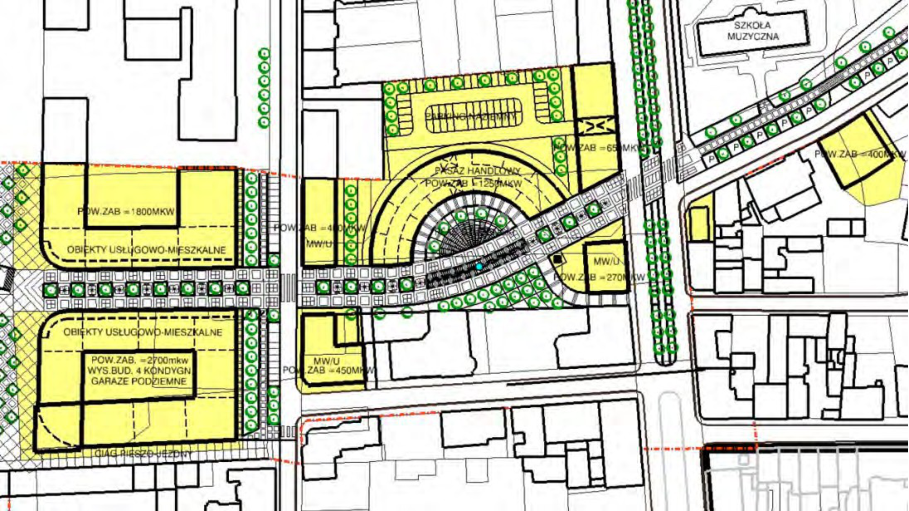
Traffic from the railway station is carried from footbridge towards the city center, and is directed to the square near bus station, where it leads in three directions: north, east and south. In the south direction, it leads to wide pedestrian route, with axially conducted rows of trees (see Figure 4). Along this road are located services and residential premises, and the pedestrian route itself connects objects of secondary and university education. Location of service premises in the ground floor, limits additional migration, and offloads traffic. In this way basic shopping can be realized by pedestrian as well as entertainment or meetings with friends. The natural approach is also to treat this route, as public space, where social life takes place, and there aren interactions between people (eg, meeting friends or close person on the way, events, happenings, etc.). Thus, the width of the route, and the spatial development of the route, must take into account firstly the possibility of permanent or temporary equipment, even taking into account the seasonality, eg. the functioning " garden cafe" or selling of goods outside. Reserve space should be designed so as not to impede pedestrian traffic, or to allow traffic without creating congestion on the route.
An important element of the project is green, which would affect the microclimate of the street - in the hot summer days gives a shadow and also protects pavements against being heated, thus the air is not so dry and hot, and thus for some burdensome, which could eg. in older people cause health complications.
Figure 4. Guidelines for potential investors. (own)
In architectural detail, the solution should take into account the varied needs of users (especially due to health restrictions). Sidewalk - materials, texture, color, scale should take into account potential users, ie. people with mobility problems, a variety of forms of movement within pedestrians: mothers with prams, people in wheelchairs, the elderly, disabled moving with a cane or crutch, or skateboarders, skaters, etc. Attention to the fact is necessary of pedestrian traffic speed, a possible collision in traffic, or to rather avoid a collision or accident, because as far as roughened pavements and uneven or no-smooth structure can give better adhesion to the ground, it can also cause tripping, nonetheless completely smooth pavements, can give a very good opportunity to move to people in wheelchairs, or rollerblades, but it may pose a risk of slipping for pedestrian.
An important issue from the point of view of the functioning of space is "the life which taking place there". The occurrence of traffic, social interactions, social control, city monitoring system - affects the sense of security, acceptance, and willingness to use it and stay in. Therefore, it is important in the urban space that proportions, scale, size, equipment, lighting, color, material, signage, ensure psychological comfort and convenience of utilisation.
CONCLUSIONS
The interdisciplinarity of "urban design" and ergonomics, as the scientific disciplines, integrates both in the pursuit of a similar purpose - to create a spatial structure tailored to the human's environment, also satisfying and taking into account their needs. At this point prof. J. Charytonowicz should be mentioned, who defines "ergonomics as the interdisciplinary science, which adapt the entirety of material surroundings to human psychophysiological needs and capabilities, (which is important) simultaneously taking into account the possibilities and needs of nature"(Charytonowicz, 2012).
Ergonomics, linked more with everyday objects or small scale architecture, also has a close relations with urban planning, because using the architectural's product in the urban space, affects the intangible - psychological human nature, on many levels. Challenging task in urban planning is the "design for all", because in this field, designing is focused on the needs of users, consisting of various type of individuals, both in terms of physical characteristics as well as psychological. Some people say that designing is a process, not a product, it aims to create products that can be used by the largest possible group of users (Trocka-Leszczynska, Tomaszewicz, Bac, .. 2009).
Achievement of this gole is just getting easier with applying new technologies and techniques of implementation, both at physical and virtual dimension of this goal, which facilitate humanity functioning in the living space. The segregation of space, separation and organization of road traffic, synchronization of operation and functioning affect the space in which men live, is intended to eliminate barriers, inconvenience, handicaps psychological and physical, discomfort. For example, implementation of traffic management in the city, with information boards on the road, or at the bus stops, helps to improve safety and traffic management (Olszewski, 2009).
Ergonomics has its own place in urban planning, because even the best-designed building which is located in the space that doesn't respect the principles of adaptation of the urban space to human psychophysiological needs and capabilities loose its value, to a significant degree.
REFERENCES
Bonnenberg W. (2012), „Relacje pomiędzy ergonomią a marketingiem w społeczeństwie sieci” in: Ergonomia w architekturze i urbanistyce, scientific editor: J.Charytonowicz., PTErg , Wroclaw, p. 11-18. Charytonowicz, J. (2012), „Ergonomia w architekturze i urbanistyce” , PTErg,, Wrocław. Charytonowicz, J. (2012), „Porozmawiajmy o ergonomii”, http://strefaergonomii.pl/porozmawiajmy-o-ergonomii Charytonowicz, J. (2009), „Ergonomia w architekturze i urbanistyce”, PTErg,, Wroclaw. Kowal E. (2002), „Ekonomiczno – społeczne aspekty ergonomii”, PWN Korzeniewski, Wł., (1989), „Budownictwo mieszkaniowe –poradnik projektanta”, Arkady, Masztalski, R. (2013), “Współczesna urbanistyka Leszna”, Oficyna Wydawnicza Politechniki Wrocławskiej Olszewski J. (2009), „Wykorzystanie zaleceń ergonomii w ograniczaniu osobom niepełnosprawnym barier architektonicznych i
urbanistycznych…” , p. 63, in: Ergonomia w architekturze i urbanistyce / scientific editor: Jerzy Charytonowicz ; Wroclaw, PTErg. Trocka-Leszczynska E. , Tomaszewicz A. , Bac A. and others. „Przystosowanie mieszkania do potrzeb osoby niepelnosprawnej w budynku wielkoplytowym w osiedlu „Kosmonautow „ we Wroclawiu , p. 88-91: in: Ergonomia w architekturze i urbanistyce / scientific editor: Jerzy Charytonowicz ; Wrocław : PTErg.
LISTED IN THE AHFE DIGITAL BOOKSTORE CATALOGUE
Explore the complete digital volume
Advances in Human Factors and Sustainable Infrastructure
Read this individual research paper free through the original publisher, or explore the full digital proceedings book.
ISBN 978-1-4951-2092-3
Explore this ISBN in the AHFE Bookstore ↗Listed in the July 2026 bookstore catalogue; search by ISBN to confirm current availability · Digital book purchase optional