Caterina Anastasia (2022). Water as a project material: Designing the Tagus Estuary Riparian Limits. In: Human Factors in Architecture, Sustainable Urban Planning and Infrastructure. AHFE Open Access, vol. 58, pp. 151–158. https://doi.org/10.54941/ahfe1002346
CIAUD, Research Centre for Architecture, Urbanism and Design, Lisbon School of Architecture, Universidade de Lisboa, Rua Sá Nogueira, Polo Universitário do Alto da Ajuda, 1349-063 Lisbon, Portugal ↗
Today, especially at a time of mobility restrictions due to the COVID-19 pandemic, we recognise the attraction of riverside promenades as well as green areas and paths along drainage corridors. As the water network has become a generator of new urban facades and a trigger of territorial regeneration, it has also come to represent a way towards improving inhabi-tants’ wellbeing and social cohesion. This work analyses 21 realised riverside regeneration projects located in the ‘City of the Tagus Estuary’ – the city set along the Tagus Estuary water system (Lisbon Metropolitan Area, Portugal). The focus is on quality factors and components that work together with the visual stimuli of the green/blue scenes. The work concludes that proximity to water, as a ‘project material’, requires conscious design of the land-water interface and its accessibility, with relevance for the ways of using and contemplating the estuarine landscape.
Studies indicate an association between exposure to green or blue spaces and human physical and mental well-being (for blue spaces see Beute et al. 2020; WHO, 2021; and Grellier et al. 2020). These works reveal that factors of quantity – the amount, types, and availability of green and blue space in urban environment and the access to them – have so far received more resea- rch than factors of quality such as the components and characteristics of blue spaces.
It is increasingly recognised that public spaces along the water (and the ‘access to quality blue spaces’ - Grellier et al. 2020) play a major role in determining the quality of our urban areas and contribute a wide range of benefits for urban populations. To answer the question ‘what makes a public space a pleasant place to be and thus used?’, Gehl and Svarre have developed a checklist to assess the quality of public space when designing a ‘pedestrian landscape’. Among the ‘12 quality criteria’ that make people feel protection, comfort, and enjoyment, they include: the visual possibilities, possibilities for sitting, standing, and walking, design for positive climatic elements, and design for positive sense-experience (Gehl and Svarre, 2013). All of these
criteria for inviting people to come and stay are generally valued by blue/green spaces, to say nothing of other aesthetic parameters.
Even if it appears that positive associations with physical and mental health are less certain for inland waters than coastal blue space (WHO, 2021), it also appears clear that, helped by more or less visual openness of the space and fluidity of the water, an increased contact with green and blue spaces can serve as a partial compensation for reduced social contact (Grellier et al. 2020). In line with the abovementioned cross-sectional researches and taking into account that research on blue spaces is limited, especially for inland water, this article aims to investigate the characteristics of river edge interventions. From an architectural and urban planning standpoint, this work plans to study projects of public spaces realised along the main riverbed of the Tagus and its drainage watercourses – the Tagus Estuary water system, Lisbon Metropolitan Area, Portugal.
Inhabitants daily rediscover the advantages of living close to water – now more than ever in a time of mobility restrictions due to the public health emergency. This interest in experiencing riverside promenades as well as green areas and paths along drainage corridors leads us to undertake this work, whose aim is to add value to ‘vicinity to water’ as a project material.
A previous work concludes that “water (in urban projects) [is] a binder that refers to the idea of continuity”, and “water (in urban projects) [is] a thick element of public space able to redesign surrounding areas” (Anastasia 2019b, p. 22). We then ask: how may such visual stimuli become a material aspect of the project? Insetting the terms of the question, we also ask: what are the basic elements that define the project along the waterline or the asso- ciated green corridors? What are their formal aspects and their materials of construction?
Responding to the lack of relevant prescriptions and design guidelines, as highlighted by numerous authors (Beute et al. 2020; Olszewska-Guizzo, 2018; and Völker Kistemann, 2013), we will consider 21 selected interventi- ons facing the Tagus Estuary system to understand commonly implemented practices for waterside projects.1
THE DESIGN OF THE ESTUARINE LAND-WATER INTERFACE The hydrographic network of the estuary crosses the Lisbon Metropolitan Area, wherein we find examples of public projects supported by watercour- ses. Surface or underground water flow appears as an appealing feature for intervention in consolidated and often degraded urban areas. Numerous public institutions in riverside conurbations have promoted the symbolic cen- trality of the estuary by linking urban renewal programs and promotions to the waters of the Tagus (Anastasia, 2019a).
This work takes into consideration 16 riverside promenades and 5 ‘gree- ner interventions (or programmes)’ along drainage corridors. The riverfronts
1We will not consider the Lisbon waterfront, which, due to the number and variety of examples, could be the subject of a separate work.
Water as a Project Material: Designing the Tagus Estuary Riparian Limits 153
along the main Tagus Riverbed represent the new fluvial façade of the old riverside city centres on both banks. In inland areas, the green corridor inte- rventions provide public open spaces and network already-existing green spaces and public facilities.
To answer the questions raised in the introduction, we note that the proje- cts aim to ‘build’ (or reconstruct) a view of the estuarine landscape, creating accessibility and paths with places to rest. Three main elements have been implemented in all the projects under consideration: treatment of the limit with the water, the continuous pathway along it, and the seating (different types of benches).
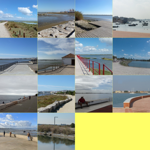
We note that almost all the interventions work with the water limit itself, minimising the barriers between the new promenades and the river area. Attempts have been made to minimize barriers to the blue scenery in choo- sing limits for the riverside promenades. The solutions range from a complete absence of physical protection to opaque, but low, walls (which often serve as seats), to barriers that are high but as transparent as possible. The inte- rventions present high and opaque walls in contact with the water in only a few cases where the new promenade is on an embankment. Cases with an absence of physical protection are managed by a promenade that is elevated with respect to the flood area of the river or, less often, through the ground sloping towards the water; except in the case of urban beaches, this is most often made of light-coloured stone blocks. In these cases, the view of the estu- ary is taken as the only guide for the entire length of the promenade along the water (see Figure 1).
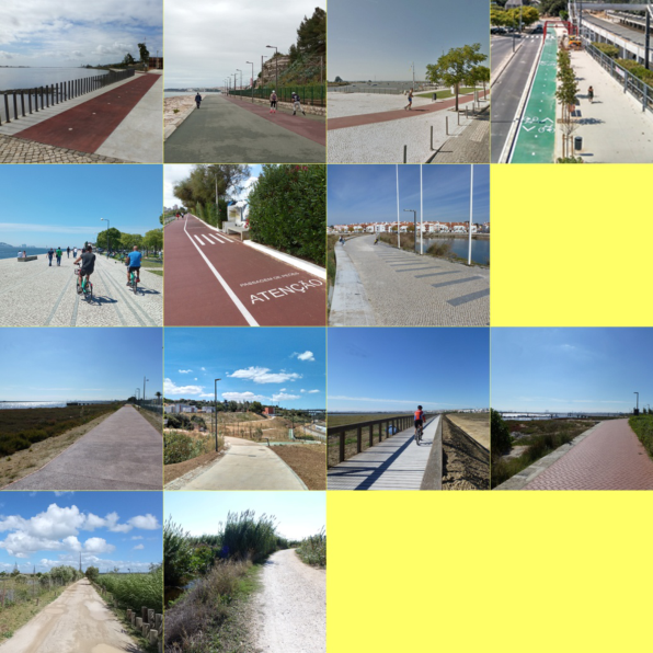
Especially in more recent interventions, a cycling and pedestrian path tends to be the primary motivation for the project. This kind of route is inserted into numerous promenades that go along the water or are surrounded by the green continuum. As shown in Figure 2, the interventions range from uniform promenades – with minimum added elements to often pre-existing paths – to subtle elements in the pavement (such as differently coloured stones) mar- king lanes for ‘soft mobility’, to the presence of a preferential lane, often highlighted in bright colours (generally green or dark red). Often marked as a ‘cycle lane’, this is the element typical of interventions with a connecting purpose. Occupying narrow strips of land along the water, cycling paths link parks and river promenades around urban centres. Such uninterrupted strips of coloured asphalt, which guide the physical activity of the users (running, rollerblading, cycling, among others), are often located on the side of the path opposite from the water, leaving the part along the stream free for wal- king. At times, especially in the more urbanised northern bank of the Tagus, a health trail, a fitness area, or a skate park may be found joined to the path (see Figure 2).
‘Contemplative experiences’ (Krinke, 2005) and ‘passive exposure’ (Olszewska-Guizzo, 2018) to environmental stimuli are facilitated in these projects with different kinds of public seating. It seems clear that the sensa- tions of green and blue scenery are apprehended most fully in moments of rest, when we can appreciate the surroundings more attentively.
Within sight of the water we find properly designed benches or low walls (protecting the path from water) that incorporate seats, though these are at
154 Anastasia
Figure 1: Different kinds of water limits: from a complete absence of physical protecti- ons – promenades elevated above the flood area or ground sloping towards the water (top) – to barriers that are high but as transparent as possible, to low opaque walls, and a few high opaque protections (bottom). (Author’s photographs).
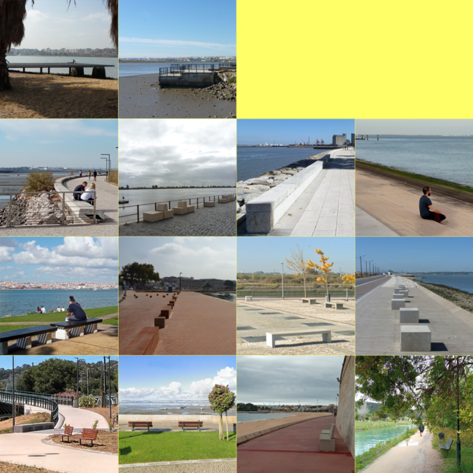
times uncomfortable and not intended for users of all ages. In almost all the more recent interventions, the benches or seats are of a harder and simpler character than those in contact with greenery. Made of materials such as stone or concrete, to better withstand the salinity and the harsh atmospheric conditions, the seats by the water are often without back-rests. These accom- modations do not seem to suggest a seating direction, allowing the view of the path or the urban fluvial façade as much as the contemplation of the water. At times, a simple difference in height between the promenade and the river area, without vertical protective barriers, serves as a seat for deep immersion in the blue scenery (see Figure 3).
Seats located in the green continuum of the drainage corridors are often made of softer materials (such as wood), more comfortable, suitable for users of all ages, and frequently characterised by a more ‘classic’ design. Here, properly designed benches are often equipped with backrests that direct one’s view across the pathway. We also find benches equipped with backrests along the river edge promenades. These kinds of seats are always placed opposite the water (allowing users to see the pathway together with the river), never directly in contact with the water (see Figure 3).
Water as a Project Material: Designing the Tagus Estuary Riparian Limits 155
Figure 2: Different kinds of cycling/pedestrian paths: from uniform promenades (bot- tom) – with a minimum of elements added to often pre-existing maintenance paths – to subtle elements in the pavement that mark paths for ‘soft mobility’, to the presence of a preferential lane highlighted by bright colours (top). (Author’s photographs).
FINAL CONSIDERATIONS Given the benefits that access to quality blue spaces brings to urban inhabi- tants, we note that, in the City of the Tagus Estuary, although water – the contact with the water, the possibility of walking along it and admiring it – inevitably are ‘materials’ of the analysed projects, their distinctiveness are not fully exploited.
We note that all the interventions are centred around the presence of water and clearly facilitate proximity to the river or the greenery located along inland watercourses. However, there remain some points that should be taken into account in future (or renewal of old) public projects of regeneration involving the Tagus Estuary water system.
Visual stimuli and the ‘sense of water’ are brought on by both the ‘scenic effect’ of visible watercourses and the ‘natural continuum’ that attends visi- ble or buried streams. These become materials of the places to be valued and emphasised (Anastasia, 2021) in the design of the three main elements identi- fied by this paper (the land-water limit, the cycling/pedestrian pathways, and the rest areas). The stimuli deriving from lines of sight – contemplative expe- riences or passive absorption of environmental stimuli – as well as physical
156 Anastasia
Figure 3: Different kinds of benches and seats along the water and pathways: from ‘simpler’ seats not suggesting a direction for sitting – platforms or low walls that make the use of seats – (top), to more comfortable and ‘classic’ benches along the pathways (bottom). (Author’s photographs).
activity become (or should be treated as) design objectives (part of the public project programme) towards mental and physical restorativeness, comfort, and social cohesion.
However, more than the land-water limit and rest areas, the layout of the cycling and pedestrian path seems to be the founding action and the most relevant element in the new fluvial promenades. Walking or cycling along the water seems to be the first way to reconnect water to daily urban life (the pri- mary goal of the projects). The Lisbon Metropolitan Area and its riverfronts are today populated with cyclists, likely encouraged by pandemic concerns and by the bicycle purchase incentives enacted by local municipalities. This phenomenon will be promoted by the connection of cycling-pedestrian soft mobility across the entire northern bank of the estuary, which seems to be a shared and achievable goal in view of the greater degree of urbanisation and the geomorphological characteristics of the water’s edge. Installation of ramps will lead to long sought-after riverfront accessibility for all categories of users.
Water as a Project Material: Designing the Tagus Estuary Riparian Limits 157
Among the characteristics that could be planned for or improved in future public river regeneration projects, we would like to indicate the following recommendations.
Regarding the water limits, the interventions we analysed very rarely use a boundary sloping down towards the water. Using this kind of land-water interface, instead of walls or parapets, would allow the public to appreciate the tidal variations that reach differences on the order of 4 metres in the estuary, would physically (and visually) introduce more the water into the project area, and would familiarise the public with its ever-shifting landscape, making it easier to appreciate its fragile and unstable state.
Regarding the rest systems (varieties of seats and benches), we note that these can always be incorporated with whatever barriers to the water are necessary (e.g. low walls that are possible to sit on). We also note that they could be more numerous, created ad hoc with the existing elements (e.g. lea- ning against protective walls), and thought of as simple flexible elements also inserted in the green expanses overlooking the river.
Regarding the soft mobility routes, we note that continuous cycling/pe- destrian practicability of riverfronts and drainage corridors appears to be a goal – perhaps heir to an idea that entrusts the bicycle with the utopia of the ‘revolution of the city’ (see Augé, 2008). This has become the manifesto of a society that increasingly sees its project as aiming at the total practicability of inhabited areas. This could easily be achieved through minor interventions such as simple maintenance of pathways already existing along watercourses – examples of the advocated ‘low intensity action promoting the commons’ (Brandão and Brandão, 2017, p. 133).
To conclude, we venture to say that the idea of a ‘practicable whole’ of riverside places will perhaps lead someone to nostalgia for ‘making one’s own way’ in the absence of a well-marked path. In other words, someone might miss the possibility of more independent, adventurous, less controlled practi- cability than what is envisaged by the analysed projects – a way of escaping the regulated routes and itineraries, a ‘pedestrian or cycling tactic’ (Cisani, 2020) capable of crossing forgotten and (previously) ignored areas.
ACKNOWLEDGMENT
This work is financed by national funds through FCT —Fundação para a Ciência e a Tecnologia, I.P., under the Strategic Project with reference UIDB/04008/2020 and UIDP/04008/2020. Research in the framework of “MetroPublicNet - Building the foundations of a Metropolitan Public Space Network to support the robust, low-carbon and cohesive city: Projects, lessons and prospects in Lisbon”, a FCT funded project (Fundação para a Ciência e Tecnologia, I.P., Ministério da Ciência, Tecnologia e Ensino Superior, Portugal, project reference. PTDC/ART-DAQ/0919/2020).
FUNDING This research was funded by the Portuguese FCT (Fundação para a Ciência e a Tecnologia) — “Orçamento de Estado do Ministério da Ciência, Tecnologia
158 Anastasia
e Ensino Superior” — and the European Commission / European Social Fund (ESF) — “ao abrigo do Quadro Estratégico Comum (2014-2020), atra- vés, nomeadamente, do Programa Operacional do Capital Humano”, under the Postdoctoral Research Fellowship, individual postdoctoral grant (SFRH- /BPD/116331/2016), carried out at CIAUD, Lisbon School of Architecture; Universidade de Lisboa, Lisbon (Portugal).
REFERENCES
Anastasia, C. (2019a). “El agua del estuario del Tajo: bien común vehículo de identidad”, in: Melgarejo, J. (ed.) Congreso nacional del agua Orihuela, Melgarejo, J. (Ed.), Universitat d’Alacant, pp. 1673–1683. Anastasia, C. (2021). “Seeing, pausing, inhabiting the riparian limits: urban proje-
cts bound to the Tagus Estuary hydrographic system”, in: Grand Grand Projects - Urban Legacies of the late 20th Century - Conference Proceedings, Tormenta Pinto, P., Brandão, A. and Silva Lopes, S. (Eds.), DINÂMIA’CET, pp. 527–539. Anastasia, C. (2019b). Urban Regeneration Projects Bound to Water: along and towards the Tagus Estuary (Portugal). Sustainability 11, 6578. Augé, M.(2008). Éloge de la bicyclette. Paris: Payot & Rivages. Beute, F., Davies, Z., de Vries, S., Glanville, J., Keune, H., Lammel, A., Marselle,
M., O’Brien, L., Olszewska-Guizzo, A., Remmen, R., Russo, A., Andreucci, M.B. (2020). “Types and characteristics of urban and peri-urban blue spaces having an impact on human mental healthand wellbeing”, report prepared by an EKLIPSE Expert Working Group. Wallingford: UK Centre for Ecology & Hydrology. Brandão, A. L., Brandão, P. (2017). Public Space, Infrastructure, Landscape: an interdisciplinary matrix for urban spatial continuity. The Journal of Public Space 2(1), pp. 123–134. Cisani, M. (2020). Paesaggi e mobilità: strumenti per le geografie del quotidiano.
Milan: FrancoAngeli. Gehl, J., Svarre, B. (2013). How to study public life. Washington: Island Press. Grellier, J., Mishra, H.S., Elliott, L.R., Wuijts, S., Braubach, M.F.W., Hall, K.L., Bell, S., White, M.P., Fleming, L.E. (2020). The BlueHealth Toolbox: Guidance for urban planners and designers. Brussels: Horizon. Krinke, R. ed. (2005). Contemporary Landscapes of Contemplation. New York:
Routledge. Olszewska-Guizzo, A. (2018). Contemplative Landscapes: Toward Healthier Built Environments. Environment and Social Psychology 3(2). Völker, S., Kistemann, T. (2013). I’m always entirely happy when I’m here! Urban
blue enhancing human health and well-being in Cologne and Düsseldorf, Ger- many. Social Science and Medicine 78(1), pp. 113–124. WHO Regional Office for Europe. (2021). “Green and Blue Spaces and Mental Health: New Evidence and Perspectives for Action”, report.
LISTED IN THE AHFE DIGITAL BOOKSTORE CATALOGUE
Explore the complete digital volume
Human Factors in Architecture, Sustainable Urban Planning and Infrastructure
Read this individual research paper free through the original publisher, or explore the full digital proceedings book.
ISBN 978-1-958651-34-6
Explore this ISBN in the AHFE Bookstore ↗Listed in the July 2026 bookstore catalogue; search by ISBN to confirm current availability · Digital book purchase optional