Ricardo Zapata, Gabriela Vega (2022). Mitigation Strategies for the Environmental Impact of Informal Settlements Over the Papagayo protective Forest in the Northwest of Guayaquil City. In: Human Interaction & Emerging Technologies (IHIET 2022): Artificial Intelligence & Future Applications. AHFE Open Access, vol. 68, pp. 166–173. https://doi.org/10.54941/ahfe1002728
The city of Guayaquil presents a constant economic growth and therefore a high demand for human labor, which leads to national migration from areas with lower labor supply, to the city, this generates an accelerated urban development and a high capital gain in consolidated areas of the city, so that the new inhabitants especially poor people to be forced to look for a habitat, and not having access to housing in a consolidated area with all basic services, seek areas with informal settlements whose cost are affordable for such dwellers.The objective of this study will be to generate a strategic mitigation plan for the environmental impact, taking as a study base the informal settlements on the papagayo protective forest in the northwest of Guayaquil.In this work, i have made a diagnosis of the current state of the Papagayo protective forest was made, in which information on the flora and fauna of the area was compiled and classified according to the level of affectation to which it has been subjected, in addition to the impact generated by informal settlements that directly affect the study area. Based on the study of concepts and theories of human settlements, environmental impacts, quantification of activities developed by the population through land use and parceling of the territorial surface affected by human settlements on the Papagayo Protected Forest using the ARCGIS geographic information system, complemented with the Analytical Hierarchy Process (AHP), a tool that facilitates complex decision making, which allows establishing the impact levels of flora and fauna, obtaining mitigation strategies for the environmental impact, improving the quality of life of its inhabitants and increasing the green area index of the area.
Guayaquil is a port city characterized by being one of the most important ports in the country and the region, it is also a city with a high rate of industrial manufacturing, generating a high labor requirement, this being an elemental source of its economic dynamics which generates a high migratory
Mitigation Strategies for the Environmental Impact of Informal Settlements 167
flow to it, so the demand for housing in the city is high, the city’s residential supply is oriented especially to people in the middle and upper socioeconomic classes, which means that low-income inhabitants have no other alternative but to settle in sectors where they can find a place to live near the city, and in most cases, they do not consider it important that the site be legalized and have basic infrastructure for living.
Since 2000, there has been a disproportionate growth of informal settle- ments from Av. Perimetral towards the northwest of the city of Guayaquil, which was developed without urban criteria or proper infrastructure or appropriate land use, encouraged by poor public policies, high demand, and the presence of leaders who invaded the land and sold it at low prices, being occupied most of the land, informal settlements reach the so-called Papagayo Protective Forest, This is national protection land declared by the Ministry of Environment and Miduvi through executive decree No. 791 on Tuesday, September 18, 2021 (MAE, 2012), where any human settlement of any kind is prohibited, but given the circumstances of lack of space to settle, the inva- ders are occupying more and more of the protected area every day and thus generate a fragmentation of the protected forest. Fragmentation is considered as a process of partial destruction of a natural habitat, resulting in seve- ral forest fragments of various shapes, sizes, and degrees of isolation which results in the interruption of ecological connectivity and is the main threat to biodiversity conservation and generation of environmental services (Tobar & Ibrahim, 2010).
METHODOLOGY
In this paper, a diagnosis of the current state of the Papagayo protective forest was made, as well as a classification of the flora and fauna immersed in it, in addition to the impact generated by informal settlements on it. Based on the study of concepts and theories of human settlements, environmental impacts, land use according to the activities carried out by the population, complemented with the Analytical Hierarchy Process (AHP), which is applied for the execution of the work, in order to improve the quality of life of its inhabitants and increase the index of green area in the area.
Environmental Impacts and Land Used in Protected Forest “Papagayo” The georeferenced cartography based on orthophotos and in situ information will make it possible to determine the number of plots that currently exist within the area delimited for the Protected Forest. Likewise, it will be possible to define the areas with the greatest extension of land, in order to establish where the greatest number of informal settlements are located.
AHP as a Strategy Selection Methodology For the analysis of the AHP hierarchical analysis process, a hierarchical stru- cture matrix is established using the Saaty scale, which allows comparison between two alternatives with respect to a selected criterion. These compa- risons will be based on information obtained in the field, such as surveys,
168 Zapata and Vega
Table 1. Matrix of selection criteria.
Table available in the original PDF paper.
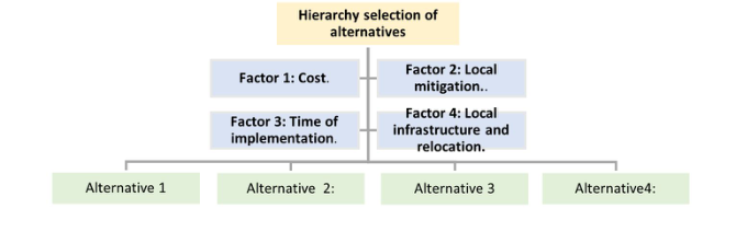
Criteria Matrix Determining Elements Factor 1 Cost Characteristic determinant items Factor 2 Local mitigation Restoration to the local ecosystem Factor 3 Execution time Estimated execution time Factor 4 Local infrastructure The type and amount of existing infrastructure
Table 2. Quantification of land use in the study area.
Table available in the original PDF paper.
Land use Area (has) Percentage Human settlements 19.73 0.55% Dry forest 2563.60 71.17% Camp 4.48 0.12% Army camp 9.71 0.27% Mining extraction 0.54 0.01% Easement strip 32.49 0.90% Future settlements 164.50 4.57% Coal production 1.39 0.04% Local neighborhoods 736.66 20.45% Chorrillo terminal 59.63 1.66% Daule Santa Elena transfer 9.39 0.26%
Total 3602.11 100.00%
studies in geo-referenced information systems, such as parceling, existing fauna and flora, current land use, satellite images.
The next step is the selection of 4 previously established criteria (table 1), which have been classified according to their cost, expected mitigation level, execution time, existing local infrastructure, for the determination of their scale of judgment of the paired comparison matrix, values will be establi- shed determined by data obtained from field work, surveys, experiences with quantitative and qualitative data.
RESULTS
Diagnosis of the Study Area
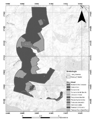
Table 1 shows the percentages of land use that are currently being used in the Papagayo Protected Forest, 28.83% has been intervened by human acti- vities, of which 20.45% is being used for private crops, in addition to the fact that 19.73 hectares have been invaded by human settlements, it was also found that 164.50 hectares (4.57%) of the territory of the Protected Forest is currently being prepared for future invasions (table 2).
The percentages of land use were quantified according to the use that is currently being made in the study area (image 1), in addition to the environ- mental impact that is being exerted in different areas (image 1), concluding that the strip located parallel to the Daule Santa Elena water transfer, is cur- rently subject to a constant invasion, without the inhabitants respecting the
Mitigation Strategies for the Environmental Impact of Informal Settlements 169
Figure 1: Current land uses of the Papagayo Protected Forest.Figure 2: AHP hierarchical structure.
areas of the Protected Forest and the easement strip established by Executive Decree No. 607, which defines the Reserved Security Area in the “Delimi- tation of the Reserved National Geographic Spaces under the control of the Armed Forces” in order to control the disorderly, informal and dispersed expansion, as well as to protect the Transfer Canal threatened by the pre- sence of settlements around it, and for this purpose, there are reserve and protection corridors of three hundred meters (300mt. ) wide, one hundred and fifty meters (150mt.) on each side of the axis of the canal, in an exten- sion of approximately 22.85 km, counted from the mouth of the Daule River to its intersection with the urban boundary of Guayaquil (Miduvi, 2010).
SELECTED STRATEGIES Four alternative implementation guidelines were determined that are focused according to sociocultural and human settlements, biophysical, economic and mobility, connectivity and energy components, which will be structured in a chronological order of implementation based on a paired selection criterion according to the AHP analytical hierarchy process (Image 2).
1 Equally preferable or important Both elements contribute equally without significant change. 3 Moderately important in relation to the other element
Empirically and by previous expe- rience, it favors in relation to the other. 5 Strongly more important and pre- ferable in relation to the other ele- ment
Empirically and from previous experience, it strongly favors the other. 7 Very strongly important in relation to the other element
The element strongly dominates the other, proven in practice, judgment, and experience. 9 Extreme importance in relation to the other element
THE element extremely dominates the other to the greatest extent pos- sible 2-4-6-8 Intermediate values between adja- cent trials
Its scale is indifferent between one element and the other.
Once the selection alternatives have been determined, as well as the sele- ction criteria and hierarchy level to be established, the paired comparison matrix is projected with its respective judgment scale and its corresponding nomenclature detailed in table 3 below.
Next, the judgment scale is determined in the paired comparison table for each of the selection alternatives, in relation to the given criteria (Cost, mitigation, execution time, local infrastructure), the same procedure is per- formed with the selection alternatives, the subscripts have been normalized to establish the coordinates of the matrices with the values of i=x , j=y, applying these criteria we obtain the summation (At) of each of the ratings using the following formula: Atj = P4
i = 1 Altij, with this the normali- zed matrix (Mn) is established which each cell is obtained with the formula Mnij = Altij/Atj, then the sum of normalized vectors Wni = P4
j = 1 Mnij is obtained; to which the averages of each one are determined and which could also be expressed in percentage with base 100 (table 4).
Equations and mathematical formulas are available in the original paper PDF.
Then, the RC index is calculated, which is designed to establish that the judgments taken present inconsistencies if the index is greater than 0.10, so it is a unit of measurement to reconsider or modify the values of the judgment scale of the paired comparison matrix, so that values less than 0.10 are a sign of reasonable levels of inconsistency. For the calculation of the validation of the Consistency Ratio, the value of λmax must be determined, applying the following formula: Pn
Mitigation Strategies for the Environmental Impact of Informal Settlements 171
No. of elements 1 2 3 4 5.000 6.000 Consistency Index Random (IA) 0 0 0.58 0.89 1.110 1.240
the following equations are obtained.
n X
n X
Wpi (1)
It then calculates the consistency index (CI), by applying the formula: CI= (λ_”max” −n)/(n−1), the random consistency index (CI) is the consistency index of a randomly generated matrix of paired comparisons (Saaty, T.L., 1980), the same depends on the number of items being compared, and the standardized values are detailed in table 5.
The formula CR=IC/IA is used to calculate the consistency ratio (CR), where a value ≤0.10 gives a reasonable consistency guideline and a CR > 0.10 gives inconsistency in decision making. For the determination of the results and level of hierarchy of execution, a results matrix (Table 6) is made, in which the results of the average vectors (Wp) of each one of the alterna- tives in relation to the given criteria are summarized; and a weighting row (Pr) is established, which is given by the Average Vectors (Wp) of the criteria comparison matrix, with these values the prioritization values (Pz) are esta- blished, which are obtained from the sum product of the vectors of each of the alternatives by the weighting level determined in the criteria comparison Pzi = P4
172 Zapata and Vega
Table 6. Validation of judgment scale by consistency ratio (CR).
Table available in the original PDF paper.
RESULTS
Execution Time
% Priority of implemen-
Criteria Alternatives (Alt)
Cost Local Mitiga- tion
Prioriti- zation (PZ) tation
Local Infra- structure and Relocation
(PE)
0.113 0.566 0.046 0.274 1.000 100%
Alternative 1 0.206 0.237 0.171 0.095 0.192 19% 3 Alternative 2 0.334 0.569 0.055 0.152 0.404 40% 1 Alternative 3 0.397 0.128 0.401 0.676 0.321 32% 2 Alternative 4 0.062 0.066 0.373 0.078 0.083 8% 4 Weighting (PR)
CONCLUSION
The strategic plan and mitigation for environmental protection against infor- mal settlements should be focused on 4 fundamental axes: Control and prevention of future settlements, eradication and relocation of current settle- ments., repair, reforestation, and restoration of affected flora and fauna and Generation of plans and strategies for the management, care and incentive to care for the affected areas and their surroundings.
The mitigation of the environmental impacts already caused on the Pro- tected Forest must be contemplated for its recovery in the medium and long term, with a policy of prevention of future sources of environmental impa- cts, as well as a reforestation plan focused especially on the areas where the impact has induced a degradation of the flora and fauna. Considering that one of the causes that promotes the development of settlements is migration from the countryside to the city, as well as family and social fragmentation, it is recommended that the competent institutions establish public policies to facilitate access to decent housing for this type of population.
REFERENCES
Chapanis, A. (1996). Human factors in systems engineering. Wiley Series in Systems Engineering and Management. Andrew Sage, series editor. Hoboken, NJ: Wiley. Folds, Dennis. Gardner, Douglas and Deal, Steve. (2008). Building Up to the Human
Systems Integration Demonstration, INCOSE INSIGHT Volume 11 No. 2. Friedenthal, S. Moore, A. Steiner, R. (2008) A Practical Guide to SysML: The Systems Modeling Language, Morgan Kaufmann; Elsevier Science. Honour, Eric C. (2006) “A Practical Program of Research to Measure Systems Engi-
neering Return on Investment (SE-ROI)”, proceedings of the Sixteenth Annual Symposium of the International Council on Systems Engineering, Orlando, FL. MAE. (2012). RO-No791 | Protective Forest and Vegetation Delineation Papagayo de Guayaquil, from Ministry of Environment website: http://areasprotegidas.am biente.gob.ec/es/content/bosques-protectores. Meilich, Abe. (2008) INCOSE MBSE Initiative Status of HSI/MBSE Activity (Pre-
sentation). Miduvi. (2010) Declaration of the Hydraulic Plan of the Santa Elena Aqueduct as a Reserved Security Area. Quito.
Mitigation Strategies for the Environmental Impact of Informal Settlements 173
Saaty, T.L., 1980, “The Analytic Hierarchy Process,” McGraw Hill, New York. Taubman, Philip. (June 25, 2008) Top Engineers Shun Military; Concern Grow. The New York Times Website: http://www.nytimes.com/2008/06/25/us/25engineer.ht ml. Tobar, D., & Ibrahim, M. (2010). ¿ Do live fences help conserve butterfly diversity
in agricultural landscapes? . Tropical Biology Journal, 58, 447–463.
Read this individual research paper free through the original publisher, or explore the full digital proceedings book.
ISBN 978-1-958651-44-5
Explore this ISBN in the AHFE Bookstore ↗Listed in the July 2026 bookstore catalogue; search by ISBN to confirm current availability · Digital book purchase optional