Abdullah Shabbir Ali, Ahmed Seffah (2026). Autonomous Aerial Surveillance AI System for Illegal E-Waste Detection and Environmental Forensics. In: Human Interaction and Emerging Technologies (IHIET-AI 2026): Artificial Intelligence and Future Applications. AHFE Open Access, vol. 201, pp. 339–346. https://doi.org/10.54941/ahfe1007188
Electronic waste (e-waste) is one of the fastest-growing hazardous waste streams globally, with 62 million tonnes generated in 2022 and only 22.3% formally collected and recycled, leaving approximately USD 62 billion in recoverable resources unaccounted for (Global E-waste Monitor 2024). Illegal dumping, driven by high compliance costs and enforcement limitations, remains difficult to monitor due to its distributed nature across remote and inaccessible areas, particularly in regions with high import flows such as Europe.This paper presents GreenPolice, a human-centric, AI-driven aerial forensics system designed to autonomously detect, classify, and document illegal e-waste dumping using drone-based imagery. Built on the DJI Phantom 4 Pro V2.0 platform, GreenPolice integrates a custom deep-learning pipeline for multi-class e-waste detection (e.g., monitors, laptops, batteries, cables, PCBs). The system prioritizes human-AI collaboration through an operator dashboard for real-time review, validation, and annotation of detections, ensuring accountability and reducing false positives in diverse conditions.Each detection generates timestamped, geo-referenced metadata packages supporting chain-of-custody for regulatory enforcement.Preliminary experiments on an initial real-world dataset of ~168 annotated images, using the latest YOLO26 model trained on Roboflow, achieve mAP@0.5 of 0.446, precision of 0.667, and recall of 0.509, validating feasibility with strong qualitative performance on cluttered scenes.This work represents phase 1 of the platform. Future phases will scale the dataset with synthetics (BlenderProc) and public benchmarks (e.g., AerialWaste [13]), add edge deployment, multi-spectral sensors, semi-autonomous planning, field testing, and blockchain logging for global operationalization.
Electronic waste is a rapidly expanding global issue, with improper disposal posing severe ecological and public health risks. Monitoring illegal dumping remains a challenge for environmental agencies due to limited personnel, the remote nature of dumping sites, and the difficulty of verifying evidence in ways that stand up to legal scrutiny. Autonomous unmanned aerial systems Received February 15, 2026; Revised February 28, 2026; Accepted March 12, 2026; Available online April 1, 2026
340 Shabbir and Seffah (UAS) and artificial intelligence (AI) offer a promising avenue for scalable, efficient, and reliable environmental surveillance (Sliusar et al., 2022; Filkin et al., 2021).
However, existing drone-based solutions primarily focus on general mapping and scene capture rather than forensic-grade detection, classification, and documentation. Similarly, most environmental AI systems lack structured evidence pipelines necessary for accountability and human-centered decision- making (Liao and Juang, 2022).
To address these gaps, we present GreenPolice, an integrated drone–AI forensic intelligence system designed to: Detect e-waste and suspicious waste clusters using a ground-based AI analysis pipeline, with future transition toward edge deployment on embedded hardware.
Further, log forensic evidence automatically with cryptographic integrity features, and, support environmental officers with a human-centered operator dashboard. Lastly, move toward autonomous or semi-autonomous monitoring workflows.
This paper describes the foundational stage of the project: dataset creation, model development, and initial system pipeline design, built around a commercial Phantom 4 Pro V2.0 drone.
Figure 1: GreenPolice system architecture overview.
RELATED WORKS AI-based environmental monitoring has grown rapidly, especially using remote sensing, but research specifically targeting e-waste detection remains limited. Existing works primarily leverage satellite imagery, which lacks the spatial resolution needed for object-level identification. Drone-based sensing enables much higher detail, yet present literature largely focuses on generic waste recognition or land-use mapping (Gassim et al., n.d.).
Computer vision methods such as YOLO, Detectron2, and SSD have achieved state-of-the-art results in object detection tasks. Recent advancements in lightweight detection architectures enable deployment on embedded devices, making them suitable for drone applications. However, few works integrate such detection systems with forensic workflows, secure metadata capture, or human-centered design principles.
GreenPolice contributes by integrating a drone-based acquisition workflow with a large-scale hybrid dataset, a fine-tuned YOLO26 model multi-class e-waste detector achieving mAP@0.5 of 0.44, a prototype human-in-the-loop operator dashboard for validation, and a forensic-grade evidence logger with
Autonomous Aerial Surveillance AI System 341 geo-referenced metadata packages designed for regulatory chain-of-custody requirements.
SYSTEM ARCHITECTURE The GreenPolice platform is designed as an integrated, modular system that combines drone-based imaging, preliminary computer vision processing, and structured evidence logging tailored for environmental investigation (Liao and Juang, 2022). Figure 1 illustrates the overall workflow.
Conceptually, GreenPolice is structured as an AI-Enabled Cyber-Physical- Social System (AI-CPSS) that synergistically connects autonomous hardware, intelligent digital processing, and human oversight to modernize enforcement against illegal e-waste dumping. The architecture is organized into three complementary layers: Physical Layer: The current sensory foundation is provided by a DJI Phantom 4 Pro V2.0 drone, which delivers high-resolution image acquisition and stable flight performance across diverse environments (DJI, 2021). In this early development phase, the drone functions primarily as a data- collection device, capturing visual imagery suitable for object identification, environmental interpretation, and forensic documentation. Telemetry streams supply essential flight and location data. Future enhancements to this layer are planned to include advanced payloads (e.g., multi-spectral, thermal, and LiDAR sensors) and more resilient communication options to support broader and more precise environmental monitoring.
Cyber Layer: Captured images and flight metadata are transferred to a processing workstation, where an initial computer-vision module performs basic scene interpretation. At present, this module focuses on image preprocessing, metadata extraction, and preparation of data for integration with a dedicated e-waste detection model. The architecture is deliberately flexible, enabling seamless insertion of advanced AI models (e.g., real-time object detection frameworks) at the edge or in the cloud without requiring structural changes. Future developments in this layer will incorporate secure, tamper-evident evidence management (e.g., blockchain-based logging) and automated report generation to strengthen traceability and legal admissibility. Social Layer: Human decision-making and investigative judgment remain central to the system. An operations dashboard allows authorized personnel to review captured data, validate detections, and manage evidence in real time. This human-in-the-loop design ensures accountability, supports quality control in challenging field conditions, and aligns with established environmental enforcement workflows. Future iterations will extend this layer with mobile applications for field officers and community-facing reporting tools to enable broader participation in environmental protection.
By maintaining clearly defined boundaries between data acquisition, intelligent processing, and human-centered validation, GreenPolice achieves extensibility, scalability, and strong alignment with human-centered investigative and regulatory needs. The current prototype establishes a robust foundation, while the layered AI-CPSS framework provides a clear roadmap toward a comprehensive aerial-forensics solution.
DATASET DEVELOPMENT Developing a high-quality dataset is a crucial first step for any vision-based environmental monitoring system. In this initial phase of the project, a preliminary image dataset was constructed to represent objects and conditions relevant to e-waste dumping scenarios. The dataset includes photographs of discarded electronics, cables, circuit components, and general clutter, as well as images of non-e-waste items that help distinguish similar-looking materials. Additional contextual images of floors, ground textures, and indoor and outdoor environments were collected to support future model generalization.
Images were captured using the Phantom 4 Pro V2.0 camera and supplemental handheld devices. These images vary in angle, lighting, and background conditions, enabling early exploration of how the system may perform under diverse settings. The initial dataset comprises approximately 168 fully annotated images (bounding boxes for multi-class e-waste), providing a foundation for proof-of-concept training, annotation work, and error analysis.
Table 1 summarizes the major categories represented in the initial dataset. As the project progresses, this dataset will be expanded with photorealistic synthetic imagery (via BlenderProc), public aerial waste benchmarks (e.g., AerialWaste (Torres and Fraternali, 2023) for real illegal dumpsite scenes with electronics annotations), and extensive field-collected drone data from multiple altitudes, environments, and real-world dumping sites.
Table 1: Initial dataset composition summary.
Table available in the original PDF paper.
Category Description Example Contents Electronic Waste Images containing discarded electronics and components old laptops, monitors, circuit boards
Wiring & Cables Scenes featuring wires, tangled
power cords, Ethernet cables
cables, and connectors
desks with tools, storage rooms
Clutter Scenes Mixed environments with ambiguous objects
drink cans, boxes, packaging
Non-E-Waste Objects
Items resembling e-waste but not relevant
floors, pavement, grass
Backgrounds Context-only surfaces and surroundings
campus grounds, open areas
Outdoor Scenes Images reflecting real deployment environments
PRELIMINARY EXPERIMENTS AND RESULTS To validate the feasibility of the proposed detection pipeline, we conducted initial experiments using YOLO26 (the latest real-time vision model from Ultralytics, 2026), pre-trained and fine-tuned on the initial dataset of approximately 168 annotated images. The dataset was split 70% train, 15%
Autonomous Aerial Surveillance AI System 343 validation, and 15% test. Training was performed on Roboflow for 100 epochs with standard augmentations and a confidence threshold of 0.5.
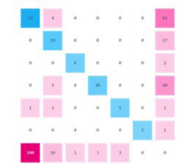
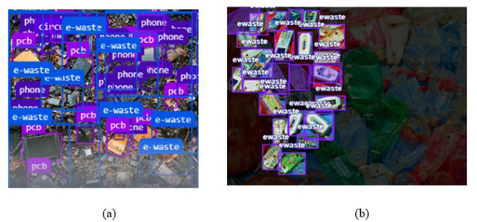
The model achieved a mean Average Precision at IoU=0.5 (mAP@0.5) of 0.446, precision of 0.667, recall of 0.509, and F1-score of 0.539. These results demonstrate viable performance on distinct e-waste classes (e.g., monitors, laptops) in controlled settings, with lower recall on tangled or fragmented items (cables, PCBs) due to limited dataset size and variability.
Table 2: Overall detection performance on validation set.
Table available in the original PDF paper.
Value Metric
0.667 Precision
0.509 Recall
0.539 F1-Score
0.446 mAP@0.5 ~0.28 (estimated) mAP@0.5:0.95
Table 3: Projected performance with dataset scaling.
Table available in the original PDF paper.
Notes Projected mAP@0.5 Images Phase Real preliminary results (this work) 0.446 ~168 Current (Initial Real Only)
TBD (~ >0.85) TBD Planned Hybrid Expansion
Planned integration of synthetic data (BlenderProc) and public benchmarks (e.g., AerialWaste) Future phases will expand the dataset to thousands of images via synthetics and public benchmarks such as AerialWaste.
LIMITATIONS AND FUTURE DIRECTIONS While the preliminary results on the initial real-world dataset (~168 annotated images) demonstrate feasible detection performance (mAP@0.5 of 0.446) on regular electronic items in cluttered scenes, several limitations must be acknowledged, reflecting the early-stage nature of GreenPolice.
First, the dataset is small and lacks aerial imagery from actual drone flights or illegal dumping sites, leading to potential domain gaps in scale, viewpoint, lighting, and environmental variability. This contributes to moderate recall on tangled or fragmented classes (e.g., cables, PCBs) and limits generalization to field conditions. Second, the forensic evidence pipeline is conceptual in this phase, with geo-referenced metadata logging implemented in prototype but cryptographic integrity features (e.g., hashing, blockchain) planned but not yet realized, reducing current chain-of-custody robustness for legal proceedings.
Third, ethical considerations, such as privacy risks in aerial surveillance over populated areas and potential model biases toward certain e-waste types or backgrounds, require further investigation and mitigation (e.g., bias audits, privacy-by-design). Finally, real-time processing on embedded drone hardware and semi-autonomous flight integration remain unexplored, potentially constraining deployment in remote, low-connectivity areas.
To address these and transition GreenPolice to operational deployment, we outline a phased roadmap:
1. Dataset Scaling and Hybrid Training (Phase 2 – Starting Q1 2026): Generate photorealistic synthetic imagery via BlenderProc and integrate public aerial waste benchmarks (e.g., AerialWaste (Torres and Fraternali, 2023) for real illegal dumpsite scenes with electronics annotations). Collect initial drone-captured aerial data to exceed 5,000 images and retrain for mAP@0.5 >0.80.
2. Controlled Field Tests (Phase 3 – Q2 2026): Safely stage discarded electronics in university-approved outdoor areas (e.g., campus grounds or desert edges in Al Ain). Conduct Phantom 4 Pro V2.0 flights at 5–30m altitudes under varied lighting/weather. Annotate 500+ new aerial images, retrain the model, and validate the operator dashboard in semi- real conditions. 3. Semi-Natural and Operational Testing (Phase 4 – Q3–Q4 2026): Collaborate with local environmental authorities for access to monitored non-hazardous waste sites. Perform grid-pattern missions with real telemetry logging. Evaluate end-to-end performance (detection mAP, false positive rate in clutter, operator validation time) and forensic package admissibility via mock legal review. 4. Advanced Features and Deployment (Phase 5 – 2027): Implement edge deployment for real-time onboard processing, multi-spectral/thermal sensors, semi-autonomous mission planning, mobile field apps, and blockchain-based tamper-evident logging.
Throughout, safety and ethics will be prioritized: adherence to UAE drone regulations (GCAA permits), avoidance of populated areas initially, and regular bias/privacy audits. These steps will ensure operational reliability, regulatory compliance, and global scalability for responsible e-waste management.
CONCLUSION
This work presented the early-stage development of GreenPolice, a drone- supported environmental monitoring system aimed at detecting and documenting improper disposal of electronic waste. The initial phase of the project focused on establishing a clear system architecture, defining the data acquisition workflow, and constructing a preliminary dataset to support future model training. Using the Phantom 4 Pro V2.0 as the primary imaging platform, the system demonstrates a practical foundation for collecting structured visual evidence that can later be integrated into automated detection pipelines. Integration of real aerial benchmarks like AerialWaste is expected to significantly improve performance. The creation of a structured evidence-logging component ensures that the project remains oriented toward real-world applicability, where traceability and documentation are essential to environmental enforcement and investigative processes. GreenPolice illustrates how integrating computer vision, autonomous drones, and human-centered design can advance sustainable environmental governance worldwide, including in high-import regions such as Europe.
Future work will involve expanding the dataset with aerial and field- generated imagery, conducting comprehensive annotation, and training a dedicated e-waste detection model suitable for deployment on lightweight platforms. Additional efforts will explore the integration of autonomous drone behavior, such as guided search patterns and adaptive monitoring, as well as user-interface enhancements to support environmental teams working in operational settings. Through these next steps, GreenPolice aims to evolve
346 Shabbir and Seffah into a robust, scalable system capable of supporting global efforts to mitigate the growing environmental threat of electronic waste dumping.
ACKNOWLEDGMENT
The authors would like to acknowledge the support of the Department of technology at Zayed University for providing access to laboratory facilities, the Phantom 4 Pro V2.0 drone, and computational resources used in this study.
REFERENCES
A. Poonawala & T. Kalsekar, “Waste Volume Estimation using Drone based Photogrammetry,” IJERT, Vol. 09 Issue 04, 2021. Denninger et al., “BlenderProc,” 2023. DJI, “Phantom 4 Pro V2.0 User Manual,” DJI, Shenzhen, China, 2021. [Online].
Available: https://www.dji.com DroneWaste, https://zenodo.org/records/17288038 E-Waste Dataset, https://universe.roboflow.com/electronic-waste-detection/e-wastedataset-r0ojc H. A. M. Gassim, V. Di Pietra & M. Piras, “Identification of Waste Materials in
Semi-Controlled Test Site Using UAV Thermal and Multispectral Images,” ISPRS Annals, X-2/W2-2025:133-2025 M. Durgun & M. Durgun, “Smart environmental drone utilization for monitoring urban air quality,” Environmental Research and Technology, 7(2):194–200, 2024 N. Sliusar, T. Filkin, M. Huber-Humer & M. Ritzkowski, “Drone technology in
municipal solid waste management and landfilling: A comprehensive review,” Waste Manag., 139, 2022. Roboflow. (2026). YOLO26 Object Detection Model. https://roboflow.com/model/yolo26 T. Filkin, N. Sliusar, M. Ritzkowski, M. Huber-Humer, “Unmanned Aerial Vehicles for Operational Monitoring of Landfills,” Drones, 5(4): 125, 2021. TACO dataset, http://tacodataset.org Torres, R.N., Fraternali, P. “AerialWaste dataset...”, Scientific Data, 2023. https://doi.
Human Interaction and Emerging Technologies (IHIET-AI 2026): Artificial Intelligence and Future Applications
Read this individual research paper free through the original publisher, or explore the full digital proceedings book.
ISBN 978-1-964867-77-9
Explore this ISBN in the AHFE Bookstore ↗Listed in the July 2026 bookstore catalogue; search by ISBN to confirm current availability · Digital book purchase optional