Erika Jaramillo, Ivette Cruzado, Walter F. Silva Araya (2026). Traffic Evacuation Simulation and Development of Contingency Plan for a Flood-Prone Community in Puerto Rico. In: Human Interaction and Emerging Technologies (IHIET-AI 2026): Artificial Intelligence and Future Applications. AHFE Open Access, vol. 201, pp. 127–135. https://doi.org/10.54941/ahfe1007167
Puerto Rico faces a constant risk of flooding due to its geographic location and the recurrence of extreme weather events such as tropical waves, cold fronts, and hurricanes. The Lucchetti community, located in the municipality of Yauco, exemplifies this vulnerability as it lies within the main channel of the Yauco River, an area historically affected by overflow and flooding events.This study aimed to analyze the flood dynamics and vehicular evacuation process in the Lucchetti urbanization in order to assess its vulnerability to extreme events and propose strategies to improve community response times and evacuation capacity.An integrated modeling approach was developed, combining hydrologic, hydraulic, and traffic simulation tools. In the first stage, the hydrologic and hydraulic behavior of the watershed was modeled using HEC-HMS and PCSWMM, incorporating the rainfall recorded during Hurricane María (2017). The watershed was delineated using a digital elevation model processed in HEC-HMS, while the average slope and flow path length were computed in ArcGIS Pro. The resulting hydrographs were exported to PCSWMM to simulate river overflow and the two-dimensional propagation of floodwaters across the community, using a 10-meter resolution mesh and natural drainage conditions.The results show that the model realistically reproduces the flooding observed during Hurricane María, reaching maximum water depths of up to 1.8 meters in critical areas of the community. From the moment the river overtops its banks until floodwater reaches 0.3 meters over the evacuation route, the available evacuation time is approximately 1 hour and 17 minutes, indicating a highly constrained response window for residents.In the second phase, a microsimulation of vehicular evacuation was performed using SUMO (Simulation of Urban Mobility) to analyze and optimize traffic flow under emergency conditions. Using real traffic data and the road network obtained from OpenStreetMap, several management strategies were evaluated. The implementation of a secondary evacuation route reduced the total evacuation time (1 h 5 min 57 s) by 53%, while the use of a traffic signal or manual control (traffic guard) achieved a 55% reduction.The findings demonstrate that the integration of hydrologic, hydraulic, and traffic models is an effective tool to strengthen community resilience and flood risk management. This approach supports the development of evidence-based emergency plans, helps optimize evacuation times, and provides technical guidance for municipal and state decision-making. Moreover, the proposed methodology is replicable and adaptable to other vulnerable communities in Puerto Rico and similar tropical regions, offering a transferable framework to enhance community response capacity and promote sustainable climate change adaptation strategies.
Puerto Rico is highly vulnerable to flooding due to its complex topography, intense rainfall patterns, and frequent exposure to tropical storms and hurricanes. While evacuation plans are commonly developed for coastal Received December 28, 2025; Revised January 14, 2026; Accepted January 23, 2026; Available online April 1, 2026
hazards such as tsunamis and storm surge, inland flood evacuation planning remains limited, particularly for small urban communities located along river channels. Flood events often disrupt transportation networks, isolate communities, and create dangerous conditions for residents attempting to evacuate without clearly defined routes or traffic management strategies.
Recent advances in hydrologic and hydraulic modeling have enabled detailed simulation of flood processes in urban environments. Tools such as HEC-HMS and PCSWMM allow for the representation of rainfall– runoff processes, river hydraulics, and two-dimensional flood propagation. However, flood hazard assessments alone are insufficient to support effective emergency response. The ability of residents to evacuate safely depends not only on flood extent and depth, but also on traffic conditions, road capacity, and evacuation management.
Traffic microsimulation models such as SUMO provide a means to analyze vehicular behavior under emergency conditions and to test evacuation strategies before real events occur. Integrating flood modeling with traffic simulation allows for a more comprehensive evaluation of risk and response capacity.
The objective of this study is to develop and apply an integrated hydrologic, hydraulic, and traffic modeling framework to assess flood impacts and vehicular evacuation performance for the Lucchetti community in the municipality of Yauco, Puerto Rico, considering Hurricane María (2017) as a reference event.
LITERATURE REVIEW
Puerto Rico is highly vulnerable to both coastal and pluvial flooding (Díaz et al., 2024). Despite this vulnerability, limited research has focused on flood risk mitigation in urban areas affected by sudden flooding caused by intense precipitation. The main atmospheric phenomena responsible for these events are tropical waves and cold fronts, which occur throughout most of the year, keeping the island under continuous flood threat (Pérez Cruz, 2018).
Globally, several studies have developed early warning tools through hydrologic and hydraulic modeling and flood mapping to analyze flood behavior in urban areas. One of the most widely used tools for this purpose is the Storm Water Management Model (SWMM), developed by the United States Environmental Protection Agency (EPA). SWMM is an open-source model commonly applied to simulate rainfall–runoff processes in urban and non-urban drainage systems (Kim et al., 2015).
Seenu et al. (2020a) applied SWMM integrated with four-dimensional geographic information systems (4D GIS) to identify flood-vulnerable areas in Hyderabad, India. Their study analyzed the spatial and temporal variability of flooding using long-term rainfall records and demonstrated the value of advanced visualization tools for urban flood management. Similarly, Alam et al. (2023) combined SWMM with ArcGIS to assess drainage congestion and generate flood hazard maps in Dhaka, Bangladesh, providing practical guidance for improving urban drainage capacity.
Traffic Evacuation Simulation and Development 129 In addition to SWMM, hydraulic models such as HEC-RAS have been widely used for river flood analysis. Rangari et al. (2019) integrated HEC-RAS with LiDAR and geographic information systems to improve flood mapping accuracy and identify high-risk areas, while Natarajan and Radhakrishnan (2020) highlighted the applicability of HEC-RAS for water surface profile calculations in river systems.
Several studies have also examined the impact of flooding on transportation systems using traffic simulation models. Pyatkova et al. (2019) used the SUMO traffic simulator to evaluate how flooding affects road mobility, showing significant increases in congestion and travel delays. To support safe evacuation planning, Fahad et al. (2019) integrated hydrodynamic modeling with traffic simulation to optimize evacuation routes and reduce travel times by identifying critical flood depth and velocity thresholds. Furthermore, Borowska-Stefańska et al. (2023) emphasized the importance of planned evacuations and community preparedness, demonstrating that pre-established strategies significantly improve transportation network performance during flood events.
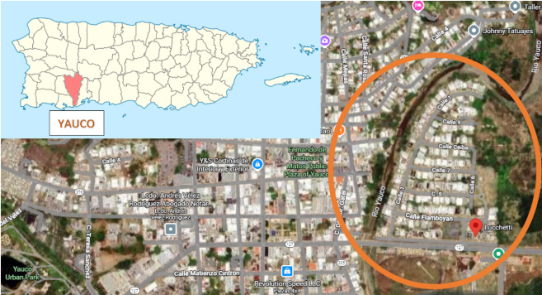
STUDY AREA The Lucchetti community is located in Yauco, a municipality in southwestern Puerto Rico, at approximately 18°02′N latitude and 66°50′W longitude (Figure 1). The community consists of approximately 155 residential units and is situated immediately adjacent to the main channel of the Yauco River. The area has a documented history of flooding during extreme rainfall events.
Figure 1: Lucchetti community in Yauco, Puerto Rico.
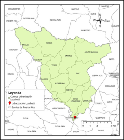
The contributing watershed upstream of the community has an approximate area of 80 km² and exhibits significant elevation variability, ranging from lowland areas near sea level to mountainous regions exceeding 1,000 m above mean sea level (Figure 2). The Lago Lucchetti reservoir is located in the midsection of the watershed and plays a critical role in regulating downstream flows.
Hurricane María, which impacted Puerto Rico in September 2017, produced extreme rainfall across the watershed, resulting in widespread
flooding and infrastructure damage. This event was selected as the reference scenario for the present study due to its severity and the availability of high- resolution hydrometeorological data
Figure 2: Study area Lucchetti community.
METHODOLOGY
The methodology for the study included hydrologic, hydraulic, and traffic evacuation modeling to evaluate flood dynamics and evacuation performance in the Luchetti community.
Hydrologic Modeling The hydrologic response of the Yauco River watershed was simulated using the Hydrologic Engineering Center’s Hydrologic Modeling System (HEC-HMS). A high-resolution digital elevation model derived from post– Hurricane María LiDAR data was used to delineate the watershed and define drainage paths. The watershed was subdivided into five subbasins based on topographic and hydrologic characteristics.
Rainfall input was obtained from a nearby USGS rain gauge station with a temporal resolution of 5 minutes, covering the period from September 19 to September 21, 2017. Losses were estimated using the NRCS Curve Number method, with curve numbers assigned based on soil type and land use data. Basin lag times were calculated following the hydrologic and hydraulic guidelines for Puerto Rico.
The Lago Lucchetti reservoir was explicitly modeled as a storage element, incorporating an updated elevation–storage relationship adjusted to account for sedimentation up to the year 2017. Outflow from the reservoir was represented using a broad-crested spillway formulation.
The resulting hydrographs were generated at key locations along the river and exported for use as boundary conditions in the hydraulic model.
Traffic Evacuation Simulation and Development 131 Hydraulic Flood Modeling
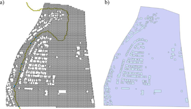
Flood inundation was simulated using PCSWMM with a coupled one- dimensional and two-dimensional (1D–2D) approach (Figure 3). The one- dimensional component represented the main channel of the Yauco River adjacent to the Lucchetti community, divided into 14 hydraulic segments. Each segment was assigned an irregular cross section derived from the digital elevation model and field observations, along with appropriate Manning’s roughness coefficients.
Figure 3: a) PCSWMM 1D hydraulic model and 2D computational mesh and, b) Boundary of the 2D computational domain and representation of obstructions.
The two-dimensional domain covered approximately 0.49 km², encompassing the community, the river floodplain, and the primary evacuation route (PR-127). A hexagonal mesh with a spatial resolution of 10 m was generated to represent overland flow. Building footprints were incorporated as obstructions to account for flow resistance within the urbanized area.
Hydrologic inflows from HEC-HMS were applied at upstream junctions, and the model was run to simulate river overtopping and flood propagation across the terrain. Flood depth outputs were analyzed to identify critical thresholds affecting evacuation routes.
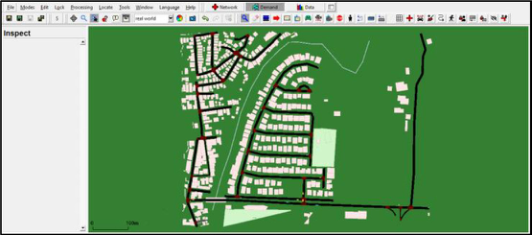
Traffic Evacuation Modeling Vehicular evacuation was simulated using the open-source microsimulation software SUMO (Simulation of Urban Mobility). The road network was extracted from OpenStreetMap and edited in NetEdit to accurately represent the geometry and connectivity of local streets and the PR-127 corridor, as shown in Figure 4.
Figure 4: Urban road network of the Lucchetti community represented in the NetEdit in.
To simulate driving behavior, two car-following models were applied depending on the scenario. In the base scenario (normal traffic conditions), the Wiedemann 99 (W99) model was used. This model is characterized by conservative driving behavior based on psychological distance thresholds between vehicles.
For the evacuation scenario, the Krauss car-following model was employed and configured with calibrated parameters to represent more aggressive and reactive driving behavior, which is typical during emergency situations. The parameter values (accel, decel, tau, minGap, and sigma) were adopted from the CAMMSE (2022) study, which was based on real evacuation data collected during Hurricane Irma.
Table 1 presents the parameter values used for both the evacuation and base traffic scenarios.
Table 1: Vehicle car-following parameters for the base and evacuation scenarios.
Table available in the original PDF paper.
Simulation Base Evacuation Model W99 Krauss
CC0 1.5 - CC1 0.9 - CC2 4 -
CC3 −8 - CC4 −0.35 - CC5 0.35 -
CC6 11.44 - Parameters CC7 0.25 - CC8 3.5 -
CC9 1.5 - tau 0.7 1.2 minGap 2.5 2
decel - 6.5 accel 2.6 4.5 sigma 0.5 0.2
Traffic Evacuation Simulation and Development 133 Several evacuation strategies were evaluated and compared to a base case scenario:
No traffic management (base case),
Addition of a secondary evacuation route,
Traffic signal control at the main intersection, and
Manual traffic management (police officer) at the main intersection.
Simulation outputs included total evacuation time and vehicle delay.
RESULTS
The results of the study included an assessment of flood inundation dynamics and vehicular evacuation performance based on the implemented simulations.
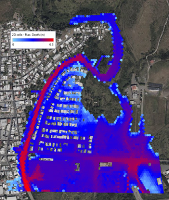
Flood Inundation Results The hydraulic simulation successfully reproduced the observed flooding patterns reported by residents during Hurricane María. Maximum flood depths within the community reached approximately 1.8 m in the most vulnerable areas. The Figure 5 illustrates the most critical stage of the flood event, corresponding to the maximum extent of inundation. River overtopping occurred early in the event, with floodwaters progressively spreading across residential streets and low-lying areas.
Analysis of flood depths along the primary evacuation route indicated that a critical threshold of 0.3 m was reached approximately 1 hour and 17 minutes after the onset of river overtopping. This time window represents the maximum available evacuation time before vehicular movement becomes unsafe.
Figure 5: PCSWMM-simulated maximum flood depth map for the Lucchetti study area.
Traffic Evacuation Results Traffic simulation results showed significant congestion at the community’s main exit under the base case scenario. The introduction of a secondary evacuation route reduced total evacuation time by approximately 53% compared to the base case. Similarly, the implementation of traffic control measures, either through signalization or manual control by a police officer, reduced evacuation time by up to 55%. Table 2 summarizes the evacuation times and relative reductions obtained for each simulated scenario.
Table 2: Results of vehicular evacuation routing along PR-127.
Percentage reduction in evacuation time relative to the base scenario (W99)
- - 28% 31% 31%
Percentage reduction in evacuation time relative to Krauss scenario These strategies improved traffic flow by reducing delays at the critical intersection with PR-127 and distributing vehicles more efficiently across the network.
DISCUSSION
The results highlight the importance of integrating flood modeling with traffic simulation when evaluating evacuation feasibility in flood-prone communities. While hydraulic models provide essential information on flood extent and timing, traffic models reveal operational constraints that directly affect residents’ ability to evacuate safely.
The limited evacuation window identified in this study underscores the need for pre-established evacuation plans and traffic management strategies. The evaluated interventions require minimal infrastructure investment and could be implemented by local authorities during emergency situations.
CONCLUSION
This study demonstrates that integrated hydrologic, hydraulic, and traffic modeling is an effective approach for assessing flood risk and evacuation performance in vulnerable communities. For the Lucchetti community, Hurricane María produced severe flooding with limited time available for safe evacuation. Traffic management strategies significantly reduced evacuation times and improved overall system performance.
Traffic Evacuation Simulation and Development 135 The proposed methodology provides a transferable framework that can support emergency planning, infrastructure assessment, and community resilience efforts in Puerto Rico and other tropical regions exposed to extreme rainfall events. Future work may incorporate real-time rainfall forecasting and dynamic traffic control to further enhance evacuation effectiveness.
REFERENCES
Alam, S., Rahman, A., & Yunus, A. (2023). Designing Stormwater Drainage Network for Urban Flood Mitigation using SWMM: A Case Study on Dhaka City of Bangladesh. American Journal of Water Resources, 11(2), 65–78. https:// doi.org/10.12691/ajwr-11-2-3 Borowska-Stefańska, M., Kwiatkowski, G., Wiśniewski, S., & Książkiewicz, P. (2023).
Evacuation planning and modelling during urban flood risk. Sustainability, 15(4), 3475. https://doi.org/10.3390/su15043475 CAMMSE. (2022). Assessing Evacuation Crash Risk Due to Road Geometry and Traffic Control (No. 2022-Project 02). Center for Advanced Multimodal Mobility Solutions and Education. https://rosap.ntl.bts.gov/view/dot/56082 Diaz, N. D., Lee, Y., Kothuis, B. L. M., Pagán-Trinidad, I., Jonkman, S. N., &
Brody, S. D. (2024b). Mapping the Flood Vulnerability of Residential Structures: Cases from The Netherlands, Puerto Rico, and the United States. Geosciences (Switzerland), 14(4). https://doi.org/10.3390/geosciences14040109 Fahad, M. G. R., Nazari, R., Bhavsar, P., Jalayer, M., & Karimi, M. (2019). A decision-support framework for emergency evacuation planning during extreme storm events. Transportation Research Part D: Transport and Environment, 77, 589–605. https://doi.org/10.1016/j.trd.2019.09.024 Kim, H., Jung, M., Mallari, K. J. B., Pak, G., Kim, S., Kim, S., Kim, L., & Yoon, J.
(2015). Assessment of porous pavement effectiveness on runoff reduction under climate change scenarios. Desalination and Water Treatment, 53(11), 3142–3147. https://doi.org/10.1080/19443994.2014.922286 Natarajan, S., & Radhakrishnan, N. (2020). An Integrated Hydrologic and Hydraulic Flood Modeling Study for a Medium-Sized Ungauged Urban Catchment Area: A Case Study of Tiruchirappalli City Using HEC-HMS and HEC-RAS. In Journal of The Institution of Engineers (India): Series A (Vol. 101, Issue 2, pp. 381–398). Springer. https://doi.org/10.1007/s40030-019-00427-2 Pérez Cruz, N. L. (2018). Implementación de Facilidades de Bioretención como una
Alternativa para el Manejo de Inundaciones Urbanas en Puerto Rico. Pyatkova, K., Lehmann, K., Krehl, A., & Schüller, D. (2019). Using traffic simulation for emergency planning under flood conditions. Transportation Research Procedia, 40, 1202–1210. https://doi.org/10.1016/j.trpro.2019.07.166 Rangari, V. A., Sridhar, V., Umamahesh, N. V., & Patel, A. K. (2019). Floodplain
Mapping and Management of Urban Catchment Using HEC-RAS: A Case Study of Hyderabad City. Journal of The Institution of Engineers (India): Series A, 100(1), 49–63. https://doi.org/10.1007/s40030-018-0345-0 Seenu, P. Z., Venkata Rathnam, E., & Jayakumar, K. V. (2020). Visualisation of urban flood inundation using SWMM and 4D GIS. Spatial Information Research, 28(4), 459–467. https://doi.org/10.1007/s41324-019-00306-9
LISTED IN THE AHFE DIGITAL BOOKSTORE CATALOGUE
Explore the complete digital volume
Human Interaction and Emerging Technologies (IHIET-AI 2026): Artificial Intelligence and Future Applications
Read this individual research paper free through the original publisher, or explore the full digital proceedings book.
ISBN 978-1-964867-77-9
Explore this ISBN in the AHFE Bookstore ↗Listed in the July 2026 bookstore catalogue; search by ISBN to confirm current availability · Digital book purchase optional