Richa Singh, Mohit Nayak, Ahmed Farooq, Jakub tkacz, Mounia Ziat, Roope Raisamo (2026). PathFinder: Haptic Wrist Guidance for Ambiguous Pedestrian Routes. In: Human Interaction and Emerging Technologies (IHIET 2026). AHFE Open Access, vol. 236, pp. 348–358. https://doi.org/10.54941/ahfe1008110
Pedestrian navigation systems commonly rely on visual guidance, but such guidance may divide attention during walking. Haptic guidance has been proposed as an eyes-free alternative, yet its effectiveness across different outdoor environments remains unclear. We report a within-subjects field study comparing minimal visual arrow guidance and wrist-worn haptic guidance across urban and non-urban pedestrian routes. Fourteen participants completed navigation tasks in both modalities and both environments using a custom Android system integrating smartphone GPS/GNSS and compass input with Bluetooth-connected wrist-worn haptic devices. Performance was assessed using average speed, route deviation, and completion time; subjective measures included the NASA-TLX and a haptic experience questionnaire. Data were analyzed using 2 × 2 repeated-measures aligned rank transform (ART) ANOVA, testing the main effects of Mode, Environment, and their interaction. Environment had a strong effect on average speed, and a significant Mode × Environment interaction indicated that modality differences depended on environmental context. Visual guidance produced lower route deviation and shorter completion times overall, whereas haptic guidance was associated with higher mental demand. Haptic experience ratings did not differ significantly across environments. These findings suggest that pedestrian navigation performance is shaped by both interface modality and environmental context, and that the benefits of haptic guidance are not uniform across settings. The results highlight the importance of ecologically valid, context-sensitive evaluation of navigation interfaces.
Screen-based, turn-by-turn pedestrian navigation has become the dominant interaction paradigm in contemporary guidance systems (Miola et al., 2024). Yet these systems require users to repeatedly attend to a handheld display, reducing situational awareness and increasing cognitive load during walking (Fonseca et al., 2021; Shimokihara et al., 2025). Despite these costs, visual navigation remains the default modality in most pedestrian systems (Kappers et al., 2024).
PathFinder: Haptic Wrist Guidance for Ambiguous Pedestrian Routes 349 A further limitation in this literature is the tendency to treat environmental context as secondary to interface design. Urban environments can support navigation through rich external cues such as landmarks, signage, and structured street networks (Kim et al., 2023). Yet even here, smartphone use requires pedestrians to divide attention between the display and a dynamic environment (Argin et al., 2020). Non-urban environments present a contrasting challenge: fewer landmarks, less structured paths, and more consequential navigational decisions make errors harder to detect and recover from (Nuhn et al., 2025). These differences suggest that navigation performance and experience may not generalise across environmental settings.
Wrist-worn haptic navigation has been proposed as an eyes-free alternative that conveys directional information through vibrotactile cues, reducing reliance on visual attention (Dobbelstein et al., 2016). However, prior work remains fragmented, with haptic and smartphone-based navigation often evaluated under differing conditions, limiting comparability (Kappers et al., 2024). It is therefore unclear whether their advantages persist in real-world settings. To address this, we conduct a field study comparing smartphone- based visual GPS and wrist-worn haptic navigation across urban and non- urban environments. Our study is guided by two research questions: RQ1: How does navigation modality (smartphone-based visual GPS vs. wrist-worn haptic navigation) affect pedestrian navigation performance?
RQ2: How does environment (urban vs. non-urban) shape navigation performance and workload, and does it interact with navigation mode?
To investigate these questions, we developed an Android application integrating GPS and compass input and conducted a field study with 14 participants. Participants completed navigation tasks using smartphone- based visual guidance and a Basslet wrist-worn haptic device across both urban streets and non-urban forest trails.
RELATED WORK
Pedestrian navigation has long been framed as an interaction problem in which users must coordinate movement, decision-making, and interface attention while traversing real-world environments (Ishikawa et al., 2008; Shimokihara et al., 2025). Screen-based turn-by-turn guidance remains the dominant paradigm for mobile pedestrian navigation, prized for its explicit route instructions but criticised for the frequent visual attention it demands (Kappers et al., 2022; Pielot & Boll, 2010; Savino et al., 2026). Because pedestrians must repeatedly glance at the device to interpret guidance, visual navigation can interfere with natural walking behaviour and reduce awareness of landmarks, obstacles, and traffic (Ishikawa et al., 2008). Prior work has measured these attentional costs using behavioural indicators such as walking speed, navigation errors, and self-reported cognitive load, raising questions suitability of screen-based guidance across contexts (Ishikawa et al., 2008; Pielot & Boll, 2010).
To reduce reliance on visual attention, researchers have explored haptic navigation systems that deliver directional cues through vibrotactile feedback, using wrist-worn, belt-based, or handheld devices (Kappers et al., 2022, 2024). By encoding turns or directional changes through vibration patterns, these
systems enable eyes-free navigation and support continuous environmental awareness (Cœugnet et al., 2018; Pielot & Boll, 2010). Controlled comparisons suggest haptic guidance can support wayfinding effectively, with some evidence of advantages in walking speed and reduced visual workload (Cœugnet et al., 2018; Pielot et al., 2012). However, the literature also reflects mixed findings: haptic effectiveness depends on factors such as cue mapping, intensity calibration, and route complexity, and performance does not consistently exceed that of visual systems (Kappers et al., 2024; Pielot & Boll, 2010). These results position haptic navigation as a viable but context-sensitive alternative to visual guidance.
Environmental structure shapes navigation performance beyond interface modality alone (Barhorst-Cates et al., 2021). Urban environments offer dense landmarks, clear signage, and regular street layouts that support route monitoring and error recovery, whereas non-urban environments provide sparser cues, irregular paths, and fewer decision points, conditions that may amplify navigational errors (Barhorst-Cates et al., 2021; Wattne & Volden, 2023). Despite this, the environmental context has received limited attention relative to modality comparisons, with most studies conducted in urban or indoor settings (Kappers et al., 2022, 2024).
Direct comparisons of visual and haptic pedestrian navigation remain limited (Kappers et al., 2022). Existing studies typically evaluate one modality in isolation or compare modalities under differing environmental conditions and participant samples, making it difficult to isolate the effects of interface type. In particular, haptic systems have predominantly been tested indoors, in simplified outdoor spaces, or in constrained urban contexts, leaving non- urban field performance largely unexplored (Kappers et al., 2024; Tang & Huang, 2025). Even though non-urban navigation is relevant to various activities such as hiking, rural travel, or emergency response, it remains understudied relative to its distinct demands (Wattne & Volden, 2023, 2025). Also, no prior work has systematically contrasted urban / non-urban conditions for both modalities within a single controlled design.
METHODS
Participants The study was conducted in Tampere, Finland, with 14 participants (7 female, 7 male; age: M= 31.0 years, SD = 5.1). All participants reported normal or corrected-to-normal vision and no mobility impairments affecting walking or navigation. Participants were also required to have no recent familiarity with either test location to reduce the influence of prior spatial knowledge. In addition, participants reported regular smartphone use and prior familiarity with pedestrian navigation applications. All participant provided informed consent and could withdraw at any time.
The study was conducted in accordance with Finland’s Medical Research Act (488/1999) and the guidelines governing the ethical review of research involving human subjects.
PathFinder: Haptic Wrist Guidance for Ambiguous Pedestrian Routes 351 Apparatus
The navigation system consisted of a custom Android application developed in Android Studio. Mapbox1 (mapping and route engine) was used for map rendering and route logic, while real-time position and heading were obtained through Android location and compass inputs (phone location and heading sensors). Position tracking was based on Android location services and compass sensing. To improve positional stability during outdoor field trials, the system additionally incorporated an external RTK-assisted GNSS2 receiver using FINPOS3 correction data delivered via NTRIP4. The resulting RTK-corrected positions were injected into Android as mock locations (injected location feed) to improve tracking accuracy. Before each trial, a predefined baseline route in GPX format (route file format) was loaded into the application and used as the reference path for real-time guidance and subsequent trajectory analysis. During each trial, the application continuously logged navigation traces (recorded movement paths) and session metadata (trial system logs) for offline analysis.
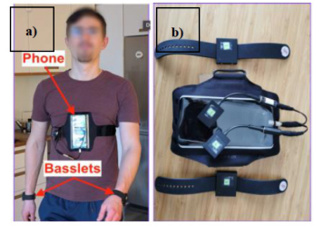
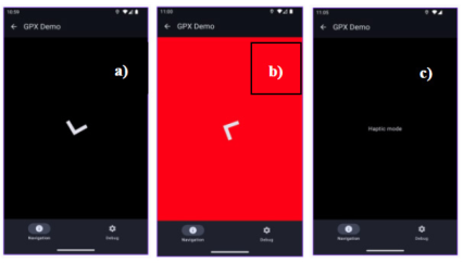
The application supported two navigation modes, visual and haptic, within a unified software architecture. In the haptic condition, the smartphone was mounted on the participant’s chest to prevent visual access, and guidance was delivered through two Bluetooth-connected Basslet devices worn on the wrists (Figure 1). The haptic cue mapping and trigger conditions are summarized in Table 1. In the visual condition, guidance was provided through a minimalist on-screen interface showing a directional arrow toward the next waypoint. No underlying map was displayed, allowing the condition to isolate arrow- based guidance from map-based spatial reasoning. Screen color indicated route status: black signalled correct alignment with the route, whereas red indicated deviation outside the tolerated corridor, while the directional arrow remained continuously visible (Figure 2).
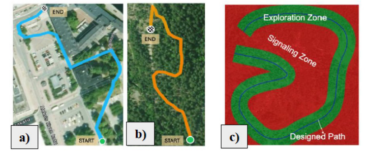
Both conditions used the same GPX-defined route model consisting of three nested regions: the Designed Path, the Exploration Zone, and the Signalling Zone. The Designed Path served as the reference trajectory for navigation and analysis. Route deviation was computed by projecting the participant’s current GPS position to the nearest segment of the GPX path. The Exploration Zone defined a tolerated corridor around the route, while the Signalling Zone triggered corrective feedback when participants deviated outside the allowed boundary, similar to prior work on deviation-triggered haptic guidance (Ziat et al., 2024)(Figure 3 c).
Waypoint progression was handled dynamically by updating the remaining route segment in real time from the participant’s current position. The sampling rate for location updates was 1Hz, while heading updates from the TYPE_ROTATION_VECTOR sensor were obtained at approximately 5 Hz. For offline analysis, orientation and direction data were logged at a sampling
rate of 10 Hz. Smoothing/filtering of heading was handled through Android’s built-in sensor fusion of the accelerometer, gyroscope, and magnetometer, so no additional application-level filtering was applied. The system also remapped coordinates to account for both standard phone orientation and chest-mounted use.
Figure 1: a) Participant wearing Basset in both hands and the mobile phone mounted on the chest. b) mobile device and Basslet.Figure 2: Smartphone display: a) Visual mode black screen with an arrow means you are walking on the right path; if red, this means you are outside the deviation zone. b) Haptic mode: no information is displayed.Table 1: Haptic cue mapping and trigger conditions.
Table available in the original PDF paper.
Cue Frequency Wrist(s) Trigger Condition Stop Condition Route correction
60 Hz (recursive)
Left or Right Heading error requires directional correction
Participant returns to on-track heading corridor
Wrong-way alert
60 Hz Both wrists Heading approximately opposite POI (~180° error)
Heading no longer in opposite direction
Arrival notification
100 Hz (3 pulses)
Both wrists Arrival at destination waypoint
End of 3-pulse pattern
PathFinder: Haptic Wrist Guidance for Ambiguous Pedestrian Routes 353 Procedure
The study was conducted in two real-world outdoor environments: an urban area (City Central Square / Keskustori Centrum)5 (Figure 3 a)) and a non- urban area (Pyynikki Nature Preserve)6 (Figure 3 b)). Each session began with a standardized briefing introducing the study and the two navigation modalities (Visual vs. Haptic). Participants were then familiarized with both: in the visual, they followed an on-screen arrow, whereas in the haptic, they received guided training on interpreting vibration cues. The study employed a within-participants 2 × 2 design with four conditions: Urban-V, Urban-H, Non- Urban-V, and Non-Urban-H, formed by crossing Environment (Urban, Non- Urban) and Modality (Visual, Haptic). Condition order was counterbalanced across participants using four fixed sequences that simultaneously balanced environment and modality order. This design controlled for learning and order effects. After a familiarization task leading participants to the route start, they completed the navigation tasks in both environments according to the assigned condition sequence.
The urban and non-urban routes were designed to be broadly comparable in navigational complexity while preserving the ecological characteristics of each environment. Both routes were approximately similar in overall walking distance and contained multiple decision points requiring directional updates. However, the environments differed intentionally in structural characteristics: the urban route consisted of paved streets, intersections, and dense external landmarks, whereas the non-urban route included irregular trails, fewer salient landmarks, and less structured path geometry. GPS reception remained stable throughout testing in both environments, although minor fluctuations typical of outdoor pedestrian navigation were observed.
Figure 3: Map showing the route, start and end position of participant, a) urban and b) non-urban path, c) Designed path, Exploration & signalling zones.
During visual trials, participants used the smartphone display for guidance, whereas during haptic trials the phone was chest-mounted and guidance was delivered exclusively through tactile feedback. Participants were instructed to always prioritize real-world safety. After each task, they completed workload and user-experience questionnaires. Navigation performance was logged automatically for offline analysis.
RESULTS
Because the study used a 2 × 2 within-subjects factorial design, Environment (urban, non-urban) and Mode (visual, haptic) were analyzed using repeated- measures aligned rank transform (ART) ANOVA. ART ANOVA was selected because the data violated assumptions required for parametric repeated- measures ANOVA. All 14 participants completed all conditions. Some GPS or device interruptions occurred during data collection, but affected trials were repeated and no trajectories were excluded. Because both factors had only two levels, post hoc comparisons were only conducted for significant interactions.
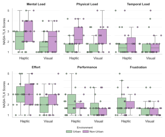
NASA-TLX (Figure 4): Mental Demand showed significant main effects of Mode, F(1,13) = 6.01, p = .029, η² = .316, and Environment, F(1,13) = 7.78, p = .015, η² = .374, with higher ratings in the haptic (M = 2.75) than visual condition (M = 2.07), and in non-urban (M = 2.71) than urban environments (M = 2.11). Physical Demand showed a significant effect of Environment, F(1,13) = 11.35, p = .005, η² = .466, with higher ratings in non-urban (M = 2.79) than urban conditions (M = 1.86). Performance ratings showed a significant effect of Mode, F(1,13) = 6.42, p = .025, η² = .331, with lower perceived performance in the haptic (M = 2.75) than visual condition (M = 2.14). No significant effects were observed for Temporal Demand, Effort, or Frustration (ps > .05), and no significant interactions were found for NASA- TLX measures.
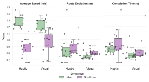
Objective measures (Figure 5): For Average Speed, there was a strong main effect of Environment, F(1,13) = 119.77, p<.001, η² = .902, and a significant Mode × Environment interaction, F(1,13) = 13.99, p = .002, η² = .518, while the main effect of Mode was not significant, F(1,13) = 0.87, p = .369. Participants walked faster overall in urban (M = 1.252 m/s) than non-urban environments (M = 0.926 m/s). Follow-up ART-C tests showed significantly higher speed in the urban haptic condition compared with urban visual guidance, t(13) = 2.99, p = .011, dz = .80. Remaining simple effects were non-significant (ps > .05).
Route Deviation showed significant main effects of Mode, F(1,13) = 7.25, p = .018, η² = .358, and Environment, F(1,13) = 7.78, p = .015, η² = .374, with larger deviations in the haptic (M = 6.18 m) than visual condition (M = 3.58 m), and in non-urban (M = 5.39 m) than urban routes (M = 4.36 m). Completion Time showed a strong main effect of Mode, F(1,13) = 28.00, p<.001, η² = .683, with longer completion times in the haptic (M = 311.12 s) than visual condition (M = 258.47 s). No significant Environment or interaction effects were observed for Completion Time.
PathFinder: Haptic Wrist Guidance for Ambiguous Pedestrian Routes 355 Within the haptic condition, Wilcoxon signed-rank tests showed no significant environmental differences for HX measures including Expressivity, Harmony, Involvement, or Realism (ps > .05).
Overall, the results indicate that environmental context strongly influenced navigation behaviour, particularly walking speed and workload, while guidance mode primarily affected route precision, completion time, and perceived mental demand. The only significant interaction was observed for Average Speed, indicating that modality effects depended on environmental context.
Figure 4: Box plot and strip plot for cognitive load metrics across urban and non- urban areas for 2 modes: visual and haptics.Figure 5: Box Plot and Strip Plot representing average speed in m/s, route deviation in meters and completion time in seconds for two modes: visual and haptics.
DISCUSSION
This study compared minimal visual arrow guidance and wrist-worn haptic guidance across urban and non-urban pedestrian routes. The results showed that environmental context strongly influenced navigation behaviour, particularly walking speed, and that the effectiveness of guidance modality depended on the environment. Visual guidance produced lower route deviation and shorter completion times, whereas haptic guidance was associated with higher mental demand.
These findings align with prior work describing pedestrian navigation as a trade-off between guidance precision and attentional demand(Ishikawa et al., 2008; Shimokihara et al., 2025). Although visual guidance improved navigation efficiency, it may also increase reliance on screen attention, potentially reducing environmental awareness (Argin et al., 2020; Cheng et al., 2022). In contrast, haptic guidance supported eyes-free interaction but introduced additional interpretive effort, reflected in higher mental demand ratings. However, haptic experience ratings remained stable across environments, suggesting that haptic interaction quality was not negatively affected by route context.
The study also highlights the importance of environmental context in pedestrian navigation. Both modalities performed better in urban settings, while non-urban routes resulted in slower speeds, greater route deviation, and higher workload. These findings support earlier research suggesting that sparse landmarks and irregular paths increase navigational uncertainty in non-urban environments (Barhorst-Cates et al., 2021; Wattne & Volden, 2023).
A limitation of the study is that the visual and haptic conditions differed not only in sensory modality but also in device placement and interaction behaviour. During haptic trials, the smartphone was chest-mounted, whereas participants actively viewed the display during visual trials. These differences may have influenced posture, hand use, and attention distribution. In addition, the modest sample size, short route lengths, and simple haptic cue vocabulary limit generalizability. Future work should evaluate larger and more diverse samples, longer navigation tasks, and hybrid multimodal interfaces while controlling for device form factor more consistently.
CONCLUSION
This study compared smartphone-based visual arrow navigation and wrist- worn haptic navigation across urban and non-urban environments. The results indicate that environmental context influenced several aspects of pedestrian navigation behaviour, particularly walking speed and selected workload measures. Visual guidance supported lower route deviation and shorter completion times, whereas haptic guidance was associated with higher mental demand despite stable experiential ratings across environments. Performance differences between modalities were not uniform across all measures, and the strongest interaction effect was observed for average walking speed.
PathFinder: Haptic Wrist Guidance for Ambiguous Pedestrian Routes 357 Overall, the findings suggest that the universal benefits of eyes-free navigation and highlight the need for context-sensitive evaluation in HCI. Rather than prioritizing a single modality, future designs should consider how interface characteristics interact with environmental structure.
ACKNOWLEDGMENT
This research was supported by the NokiaPathFAInder and Google Intelligent Haptic Mediation (IHM) Projects and conducted at Tampere University, Finland.
REFERENCES
Argin, G., Pak, B., & Turkoglu, H. (2020). Between Post-Flâneur and Smartphone Zombie: Smartphone Users’ Altering Visual Attention and Walking Behavior in Public Space. ISPRS International Journal of Geo-Information, 9(12), 700. https:// doi.org/10.3390/ijgi9120700 Barhorst-Cates, E. M., Meneghetti, C., Zhao, Y., Pazzaglia, F., & Creem-Regehr, S.
H. (2021). Effects of home environment structure on navigation preference and performance: A comparison in Veneto, Italy and Utah, USA. Journal of Environmental Psychology, 74, 101580. https://doi.org/10.1016/j.jenvp.2021.101580 Chaudhry, O., & Mackaness, W. (n.d.). Rural and Urban Road Network Generalisation Deriving 1:250,000 from OS MasterMap. Cheng, B., Wunderlich, A., Gramann, K., Lin, E., & Fabrikant, S. I. (2022). The effect
of landmark visualization in mobile maps on brain activity during navigation: A virtual reality study. Frontiers in Virtual Reality, 3, 981625. https://doi. org/10.3389/frvir.2022.981625 Dobbelstein, D., Henzler, P., & Rukzio, E. (2016). Unconstrained Pedestrian Navigation based on Vibro-tactile Feedback around the Wristband of a Smartwatch. Proceedings of the 2016 CHI Conference Extended Abstracts on Human Factors in Computing Systems, 2439–2445. https://doi.org/10.1145/2851581.2892292 Fonseca, F., Conticelli, E., Papageorgiou, G., Ribeiro, P., Jabbari, M., Tondelli, S., &
Ramos, R. (2021). Use and Perceptions of Pedestrian Navigation Apps: Findings from Bologna and Porto. ISPRS International Journal of Geo-Information, 10(7), 446. https://doi.org/10.3390/ijgi10070446 Ishikawa, T., Fujiwara, H., Imai, O., & Okabe, A. (2008). Wayfinding with a GPSbased mobile navigation system: A comparison with maps and direct experience. Journal of Environmental Psychology, 28(1), 74–82. https://doi.org/10.1016/j. jenvp.2007.09.002 Kappers, A. M. L., Holt, R. J., Junggeburth, T. J. W., Oen, M. F. S., Van De Wetering,
B. J. T., & Plaisier, M. A. (2024). Hands-Free Haptic Navigation Devices for Actual Walking. IEEE Transactions on Haptics, 17(4), 528–545. https://doi.org/10.1109/ TOH.2024.3405551 Kappers, A. M. L., Oen, M. F. S., Junggeburth, T. J. W., & Plaisier, M. A. (2022).
Hand-Held Haptic Navigation Devices for Actual Walking. IEEE Transactions on Haptics, 15(4), 655–666. https://doi.org/10.1109/TOH.2022.3209350 Kim, G., Yeo, D., Lee, J., & Kim, S. (2023). Simulating Urban Element Design with Pedestrian Attention: Visual Saliency as Aid for More Visible Wayfinding Design. Land, 12(2), 394. https://doi.org/10.3390/land12020394
Meier, A., Matthies, D. J. C., Urban, B., & Wettach, R. (2015). Exploring vibrotactile feedback on the body and foot for the purpose of pedestrian navigation. Proceedings of the 2nd International Workshop on Sensor-Based Activity Recognition and Interaction, 1–11. https://doi.org/10.1145/2790044.2790051 Miola, L., Muffato, V., Sella, E., Meneghetti, C., & Pazzaglia, F. (2024). GPS use and
navigation ability: A systematic review and meta-analysis. Journal of Environmental Psychology, 99, 102417. https://doi.org/10.1016/j.jenvp.2024.102417 Nuhn, E., Ehrig, M., Engemann, L., Heißerer, F., Maltan, J., Ruf, J., & Timpf, S.
(2025). Measuring Landmark Salience in Rural Areas: A Comparative Study of Two Models. AGILE: GIScience Series, 6, 1–13. https://doi.org/10.5194/agile- giss-6-7-2025 Pielot, M., & Boll, S. (2010). Tactile Wayfinder: Comparison of Tactile Waypoint Navigation with Commercial Pedestrian Navigation Systems. In P. Floréen, A. Krüger, & M. Spasojevic (Eds.), Pervasive Computing (Vol. 6030, pp. 76–93). Springer Berlin Heidelberg. https://doi.org/10.1007/978-3-642-12654-3_5 Savino, G.-L., De Bellis, E., Kirkham, R., & Schöning, J. (2026). Evaluating route
preview as an alternative to turn-by-turn navigation in pedestrian mobility. PLOS One, 21(3), e0340711. https://doi.org/10.1371/journal.pone.0340711 Shimokihara, S., Tabira, T., Ikeda, Y., Maruta, M., Han, G., Kamasaki, T., Hidaka, Y., Akasaki, Y., Kukizaki, W., & Kumura, Y. (2025). Association between smartphone glances during application-based navigation and pedestrian navigation performance: A real-world experimental study. mHealth, 11, 63–63. https://doi.org/10.21037/ mhealth-25–33 Tang, S., & Huang, G. (2025). Navigation Assistance Via Haptic Technology for Blind or
Low-Vision Users: A Scoping Review. Proceedings of the Human Factors and Ergonomics Society Annual Meeting, 69(1), 1–6. https://doi.org/10.1177/10711813251360706 Wattne, O. E., & Volden, F. (2023). Waylosing and wayfinding in the outdoors: A typology of wayfinding approaches to problem-solving when temporarily lost. Journal of Navigation, 76(6), 603–626. https://doi.org/10.1017/S0373463324000067 Wattne, O. E., & Volden, F. (2025). Wayfinding behaviours in natural environments.
Journal of Navigation, 1–15. https://doi.org/10.1017/S0373463325101367 Ziat, M., Batjargal, A., Hojatmadani, M., & Xiao, S. (2024). Determining the Minimal Deviation Limit for Haptic Feedback in Veering Correction during Blindfolded Walking. 2024 IEEE Haptics Symposium (HAPTICS), 73–78. https:// doi.org/10.1109/HAPTICS59260.2024.10520866
SEARCH THE AHFE DIGITAL BOOKSTORE BY ISBN
Explore the complete digital volume
Human Interaction and Emerging Technologies (IHIET 2026)
Read this individual research paper free through the original publisher, or explore the full digital proceedings book.