Eric Holder, Florian Motz, Himeh Horoufchin, Michael Baldauf (2021). Concept for the Integration of Information Received Via Communication Equipment with Onboard Navigational Systems. In: Advances in Human Aspects of Transportation: Part I. AHFE Open Access, vol. 15. https://doi.org/10.54941/ahfe100622
This paper describes project work supported by the German Ministry of Transport, Building and Urban Development (BMVBS) to perform an in-depth evaluation of the transfer and presentation of information received via communication equipment on onboard navigational displays. The goal was to identify safety-relevant information items and then map the flow of these items (in current operations and into the foreseeable future) when received via communication systems and integrated into navigational systems, identifying the optimal workflow, display and format for presentation. This paper will focus on the investigations and field studies conducted to investigate the requirements for integration and presentation of this information on onboard navigational systems. The results describe an outline and concept for managing and integrating communication information based on the Integrated Navigation System (INS) concept, including the classification and prioritization of safety-relevant information objects; and the definition of the task and information-related design requirements for integration, presentation, and usage of the prioritized information items onboard. Also included is a concept for a novel human machine interface (HMI) for message/information handling. Project tasks were conducted with special reference to the modular concept of an Integrated Navigation System and developments within e-Navigation.
Modern ship bridges are highly-complex man-machine systems. As such, the safety and efficiency of their handling is dependent on the interaction between the human and the machines during the accomplishment of tasks. Humans can fulfill their assigned monitoring, control, and decision tasks (e.g., collision avoidance, conning, and navigation) most effectively, if the information flow between them and the systems on the bridge is adapted to the human’s needs, skills, and abilities.
The continuously-developing e-navigation concept of the International Maritime Organization (IMO) aims to harmonize the collection, integration, exchange, presentation and analysis of maritime information onboard and ashore by electronic means to enhance berth to berth navigation and related services (IMO, 2011). The current separation of communication systems and navigational systems does not meet the requirements for safe navigation to integrate all means and information required for decision making. Onboard the hydrographical, meteorological and other safety-related information is typically presented on the communication equipment directly without filtering or solely as paper print-outs with minimal options for efficient integration and use with the information presented on navigation tools and displays. Technical as well as legal conditions (e.g., separation of responsibilities for radiocommunications and safety of navigation in the Safety of Life at Sea Convention – SOLAS chapters IV and Human Aspects of Transportation I (2021)
V) hinder the integration of information provided by communication equipment in the navigational systems, which reduces their utilization (IMO, 1974).
A task-oriented integration and presentation of information, when all the necessary information for the respective task and situation is available in a fast, reliable, consistent and easily interpretable format, will support the officers onboard and personnel ashore in their decision making and enhance the safety of navigation. The solutions for integration should improve the safety of navigation and enhance data transfer, both between vessels and also between vessels and shore-based authorities, without increasing the workload of the user or producing information overload.
The aim of this project for the German Ministry of Transport, Building and Urban Development (BMVBS) was to perform an in-depth evaluation of the transfer and presentation of communicated information required for maritime safety. The goal was to identify safety-relevant information items and then map the flow of these items (in current operations and into the foreseeable future) when transferred via communication systems to and from navigational systems, identifying the optimal workflow, display and format for presentation.
This paper describes the investigations and field studies conducted to investigate the requirements for integration and presentation of this information on onboard navigational systems. The results describe an outline and concept for managing and integrating communication information based on the Integrated Navigation System (INS) concept, including the classification and prioritization of safety-relevant information objects; and the definition of the task and information-related design requirements for integration, presentation, and usage of the prioritized information items onboard. Also included is a concept for a novel human machine interface (HMI) for message/information handling. Project tasks were conducted with special reference to the modular concept of an Integrated Navigation System and developments within e-Navigation.
DEFINING THE PROBLEM AND REQUIREMENTS The first steps towards defining the design space was to determine what information is out there, or could realistically become available in the future, to be integrated, the context that the information is delivered and used in, and the related problems that mariners were currently experiencing. This would provide the foundation and starting point for understanding the situation and user requirements. This information was then used to develop concepts for managing and integrating information, the user requirements and functional requirements, and a prioritized list of information items to focus on. A risk identification and control option analysis for the sending and receiving of safety-related information was also performed but will not be described in the scope of this paper. Further details of the methodologies used and output at each step are described in the following sections.
Information, Context, and Problems Various methods were employed to understand the information that is currently available, and could be available in the future, along with how that information would ideally be used and the problems and constraints in doing so. These methods included reviewing the literature available, conducting observations, and a series of mariner interviews and surveys. The literature review also included a review of the regulatory requirements, such as SOLAS Chapters IV and V, along with the existing bridge design requirements. The Integrated Navigation System (INS) bridge concept was identified as a target application environment based on its modular, task-focused, concept for integrating relevant information as is described in detail in the IMO’s INS performance standard (2007).
This understanding was augmented with a review of the communication equipment and onboard context, considering the Global Maritime Distress and Safety System (GMDSS), Maritime Safety Information (MSI), radio watch guidelines, distress communications processes, additional information and features available from chargeable services, and how this equipment and information were being used.
This information was organized into a work domain analysis, detailing the information used, along with the communication system(s) used and specifications by voyage phase (sea area). The work domain analysis was then validated in a series of mariner interviews at the World Maritime University.
Interviews were then conducted onboard two ferries to define further the initial user requirements and problems Human Aspects of Transportation I (2021) experienced regarding communication management and the transfer of information from communication equipment into the navigational systems. The interview protocol was based on the results of the worldwide user needs study conducted by the BMVBS (Motz et al., 2009). This opportunity also allowed for observation of the working practices while underway. To aid in the development of design requirements for a communication management system an Applied Cognitive Work Analysis (ACWA) was conducted to detail the cognitive demands and decision making for information handling and processing onboard. This is described in detail in Dalinger and Motz (2011) and will not be described here.
Concept for Integration and Presentation The results of the initial analysis revealed a need for user-selectable presentation of information received via communication equipment on the navigational displays of the ship’s bridge. This concept is also now integrated into the IMO’s e-navigation strategic implementation plan which calls for “Integration and presentation of available information received via communication equipment in graphical displays (NAV 58/WP.6/Rev.1)”. In order to achieve this goal it is necessary to improve communication management. Based on the preceding research the following communication management objectives were defined:
Task-oriented integration of information received via communication equipment in shipboard navigation systems.
User-selectable filtering and routing of information to prevent information overload.
Data evaluation (quality assurance) and storage.
Provision of source and channel management (selection of best connection according criteria, e.g., content, integrity, costs).
Increased availability and reliability of information due to efficient use of different communication channels.
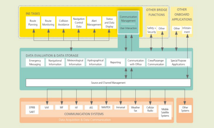
The realization of these objectives needed to be supported by a communication management architecture on both the ship and shore-side that is designed to allow access, selection, sorting, filtering, and presentation of the information. Fraunhofer FKIE, in cooperation with the members of the national e-navigation working group, developed a proposal for a detailed shipboard architecture based on the modular concept with INS as core element. Figure 1 provides an overview of the concept of the onboard integration. This paper is focused on the first two objectives.
Figure 1. Concept for Communication Management
Human Aspects of Transportation I (2021)
Organizing and Prioritizing Communicated Information The previous steps determined the types of communication information that are received on the ship’s bridge from various sources (e.g., Vessel Traffic Services, other ships, coastal authorities, company, etc.) via various media (e.g., AIS, radio, satellite, etc.) and the INS as the best bridge system option to integrate this information. To allow for an initial classification of the safety-relevant information we identified categories of generic information types based on the overall type of information (i.e., Emergency Information, Meteorological Information, Hydrological Information, Navigational Information, Traffic Information, Communications with Office and Authorities, and Security Information) and then sub-categories based on the general properties of the message that impacted presentation (priorities and graphical presentation qualities). Specific examples that required special presentation consideration due to priority or presentation properties were also identified. This path was chosen due to the abundance of specific information items that can be referred to in a communication that would have similar display properties (e.g., all the updates concerning specific chart-referenced features of the same priority level can use the same workflow and utilize pre-existing symbology for graphical presentation).
A matrix was developed to list the information items, details concerning the information included, the INS task supported (and how), suggested presentation format and workflow, timing information, sources of the information, additional considerations, and references. The INS modules of primary interest for presentation of safety-relevant navigational information objects are the Route Planning, Route Monitoring, and Collision Avoidance modules. Other modules considered are the Navigation Control Data, Status and Display Data, and Alert Management modules, as well as the development of any new tasks required. Modes of other INS tasks, such as the Search and Rescue mode of the Route Monitoring module, were also included in the considerations.
The matrix was used as the base to begin the process of prioritizing items and safety-related information objects for detailed evaluation. The goal was to focus on a limited number of items (4-7) with the highest compelling need for the users and to produce detailed workflows and display requirements for these items. These items would be evaluated by representative end users using a variety of methodologies, as appropriate for the situation.
The next step was to condense the matrix items into a shorter workable list and then to evaluate this list in reference to existing functionality that could support evaluation (e.g., AIS Application Specific Messages-ASMs, ECDIS add- info, prototypes in development). Information items were coded for current availability along with which specific components of that information were included. For example under available traffic routing information there is marine traffic signal information slots available via AIS Binary Messages for name, position, status of signal (regular or irregular), signal in use (inbound, outbound, both, time of expected shift of direction). Marine manufacturers and e-Navigation testbeds were then identified and contacted to confirm their priorities, target products both existing and under development, evaluation results to date, and planned evaluations. This information was then used to determine a list of priority items for this project.
The current high-priority list of 7 items is described below along with the logic of that item’s selection. Key considerations included: user requested features, relevance to INS, practicality of development and evaluation during the project timeline, and inclusion of items that demonstrated a range of the features and functions of a communication management system.
Item 1—Message/Information Handling HMI (MIHI): This item is the human-machine interface (HMI) for message handling and display selections. It was clear that large amounts of information will be available via communication equipment and not all of this information should be shown on navigation displays, on all task-specific displays, or in every situation and that some of this information will not arrive in a format ready for presentation. Therefore a Message/Information Handling HMI (MIHI) was seen as a critical focus area for the project as it represent a key HMI for user interaction within integrated communication management and navigation display. No was found of any manufacturer currently developing this HMI, leaving a potentially large gap in the implementation of the communication management concept. The focus was placed on communications with graphical presentation qualities, or other INS display properties.
Item 2—Alterations to Ownship Route: This item addresses communications containing alterations to the ownship route (e.g., recommended for safety, economy, or required). There can be several different reasons for alternative Human Aspects of Transportation I (2021) route suggestions (e.g., company, ice, piracy, passing arrangements, closed fairway, etc.) and each of these might require a different workflow and target navigational display (e.g., route planning, route monitoring, collision avoidance). Answering these questions was seen as critical to the HMI design and evaluation process as it is discussed controversially within the development of IMOs e-navigation strategy implementation plan. The workflow for new ownship route information needed to be examined from receipt, to viewing/display, route evaluation, acceptance or non-acceptance, modification, and then potentially transfer to other relevant displays and databases.
Item 3—Geo-referenced Locations to Avoid or with Special Procedures: This item concerns communications containing updates with geo-referenced locations to avoid (hazards or regulations) or with special procedures (e.g., speed or fuel restrictions). These will probably be the most common items in everyday practice so should be included, along with the ability to integrate evaluation and presentation features with existing route checking functions (alerts). Most of the groundwork for the display of these solutions has been completed in testbeds under the pretense of Maritime Safety Information (e.g., ee-INS, Mona Lisa, Transas, Jeppesen-Kongsberg Sea Trials, etc.) or could be demonstrated using the ECDIS add-info feature. The goal in this project was to conduct an evaluation of the existing solutions and the pros and cons of various presentations and existing gaps (currently integration with ECDIS or INS display is one gap). Particularly relevant were time-dependent items (e.g., restricted areas, special procedures, temporary obstruction, closed fairways) that require comparison between the time they are applicable and the planned/actual transit time. Updates with shorter term notification than Notams were also relevant, as was the question of if vetting and packaging of the information pre-dissemination should be, or will be, required. These information items can interact with the message/information handling workflow (see item 1 above) as well, especially for information that should not be automatically presented on INS task displays.
Item 4—Safe-Depth Information: This item concerns communications containing safe-depth information (tidal information and under keel clearance). Mariners surveyed reported this information to be a high priority (Motz et al., 2011). The goal was to compare the various ways this information could be integrated with static data, namely Electronic Nautical Chart (ENC) data, and displayed (e.g., dynamic contours, go zones, no-go zones, including bathymetry) and to document the pros and cons and variations by contextual factors. One variable of particular interest was the differentiation between real-time use (Route Monitoring) and planning use (Route Planning) and the impact on the display requirements and information required.
Item 5—Dynamic Air Gap Information: Air Gap information was another priority item reported by the mariners surveyed (Motz et al., 2011) and was not being addressed in existing projects and prototypes. Another advantage of air gap information was that it incorporates sensor data, broadening the scope of information sources. The goal was to compare the various ways this information could be displayed (e.g., passing areas with acceptable or unacceptable clearance, 3D representation, tabular format, inclusion of an alert for imminent danger) and to document the pros, cons and variation by contextual factors.
Item 6—Collision Avoidance Information: This item concerns the exchange of route, maneuver, or intention information for collision avoidance. It was determined that research must first examine the question of the usefulness and reliability of this information, and if an ideal workflow to combat clutter exists (e.g., selective presentation). These risks needed to be evaluated along with whether the workflow could be structured in a way to confirm intentions to follow the COLREGS rather than violate them.
Item 7—Meteorological and Hydrographic Data That Impacts Conning: This item concerns the near-term information that impacts route and steering (conning). This includes the representation of set and drift (current) and leeway (wind) and their impact on steering and ship handling. This may also include high wave prediction, as well as parametric rolling condition monitoring. This subset of data has a more direct impact on short-term planning and therefore was listed as a separate, higher-priority item. This would exclude data from ship sensors used for real-time conning as that is not a communication paradigm. This is therefore considered primarily for Route Planning and perhaps Route Monitoring display, rather than the Navigation Control Data display.
Items Not Included in the Priority List: The following items were identified as interesting but only to be included in evaluations as time and resources allowed. These items included: storm information that was not captured in items 3 or 7, piracy information, general meteorological and hydrographic data not covered in priority items, ice information, search and rescue information, pilot information/pilot services, the use of textual information for collision avoidance, and security-terrorism information. Human Aspects of Transportation I (2021)
DETAILED EVALUATION OF PRIORITY ITEMS The priority items were then evaluated in detail to further define the user requirements, functional requirements, workflow, and the optimal presentation parameters for effective solutions. These definition steps included ongoing human factors review, as well as interviews and simulator evaluations of design concepts and mock-ups. An overview of the evaluations is provided in the following sub-sections. The detailed results are not discussed due to space constraints. The results are reflected in the example design requirements presented in the example requirements, recommendations, and cautions section that follows.
Guiding Principles The context and constraints on receiving and displaying these types of information items on navigational displays, both current and anticipated for the e-navigation future, needed to be understood and considered when defining solutions. The following considerations were identified as ones with a significant impact. Large amounts of information are already available, and this amount will likely increase in the foreseeable future of e-navigation through advances in data production, storage and transmission technologies and general trends in information sharing. Not all of this information should be presented on navigational displays (e.g., irrelevant, inaccurate, etc.). Not all of this information is relevant to every task display (Route Monitoring, Collision Avoidance, etc.). Not all information is relevant to every situation (e.g., location, vessel type, etc.). Not all information will arrive formatted for integration with navigation. The point to take away from this list is that it is very important to consider the content, timing, workflow, presentation format, and relationship to the mariner’s tasks and overall bridge resource management when defining solutions.
It is also important to learn from the mistakes made in the past and to avoid common human-centered mistakes made in the maritime bridge environment. These include problems such as lack of standardization, inconsistent presentation of information or control-display relationships, unnecessary levels of complexity, and information overload.
Route-Exchange Evaluation FKIE participated in a preliminary evaluation of the concept of Vessel Traffic Service(VTS)-suggested route alterations conducted on June 21st, 2012 at Chalmers Technical University, Lindholmen, in their Transas Full- Bridge Simulator. Two experienced mariners participated in the evaluation. Each participant completed three scenarios. The first scenario’s VTS route suggestion was provided via an electronic message along with the suggested route displayed on the master ECDIS (in blue) and involved a significant alteration to the planned route with some lead time to make the decision. The reason for the alteration was not initially provided to the mariner but was due to an accident prohibiting passage through the planned channel. The second scenario’s VTS route suggestion was provided via VHF radio communication along with the route displayed on the master ECDIS (in blue) and involved a switch between the Southern and Northern entrance channel for a port approach due to heavy traffic and with a very short lead time. The third scenario involved a vessel docked and loading with 12 hours before expected departure. The participant was instructed to explain the route planning process and provided feedback on a paper-based mock-up of a route planning and submittal/approval tool envisioned for the Mona Lisa Project.
The evaluation provided a great deal of information concerning the information required by the onboard personnel, along with considerations and concerns when receiving route suggestions from a Vessel Traffic Service. The primary factors were interrelated and included: trust in the route and its applicability (safe passage) for the specific ownship; legal considerations and responsibility if the route was, or was not, accepted; and the lead time required for a route suggestion to allow the onboard personnel to make the decision.
Evaluation Conducted With Maritime Pilots FKIE conducted interviews with maritime pilots on August 22nd, 2012 concerning the information items received via communication equipment that were prioritized for display via the INS. The interviews were conducted in a group setting with 2 experienced pilots and 2 representatives from a software company participating. The interviews were semi-structured with a list of discussion items and questions but allowing the respondents as much flexibility as possible to provide their input. Human Aspects of Transportation I (2021)
The participants were given an overview of the project and its goals and informed that the goal was to collect their feedback and input on the priority items received via communication equipment to be presented on an INS and also the best manner to integrate that information. Pilots were asked to describe how they receive, organize, integrate, disseminate, and display information in their current operations. They were then informed that the initial prioritized list of information items would be reviewed one at a time at the conceptual level. The pilots indicated if that item was applicable in their operations and/or if they had experience and input to provide. If not, that item was skipped. The pilots then described how they envisioned this information being shared, integrated, and displayed. The pilots were then shown some example portrayals of those information items and discussed those further. The pilots were encouraged to suggest additional information items or use-cases.
World Maritime University (WMU) Evaluation The goal of the WMU evaluation was to examine the integration of information typically provided through communication equipment with the information available on the navigation displays of the ship’s bridge. The evaluation was conducted between November 6th and November 8th, 2012 at the World Maritime University in Malmö, Sweden. The evaluation consisted of two parts, a simulation part and a semi-structured interview part.
Participants: Over 3 days, 9 voluntary participants (8 male; 1 female) completed the evaluation. The participants were all students in the Master’s program at the World Maritime University (WMU). Years of sailing experience ranged from 7 to 25 years (average = 13 years). Positions held included: Master, Captain, 1st Officer, 2nd Officer, and Chief. Vessel types included: container ships, bulk carriers, tankers, ferries, passenger ships, RORO vessels, patrol boats, war ships, dredgers and LPG carriers. Geographical areas of operation covered the following locations: Mediterranean Gulf, Finland, Persian Gulf, Japan, North Sea, Indian Ocean, English Channel, Central America, Asia (Japan, Korea), Swedish Waters, Kiel Canal, East African Coast and the Strait of Malacca. Years of experience in working with ECDIS ranged from 0 to 7 years (average = 2.5 years). To assess familiarity with modern technology, participants were asked if they had experience with either a smart phone with internet, tablet PC, or Ipad. All participants reported that they had experience with at least one of these items.
Simulator Evaluations: Each participant completed two simulator scenarios, one involving a route suggestion provided by the company, and one involving the integration of MSI information concerning lost containers.
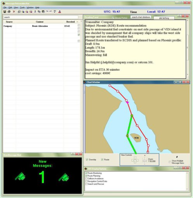
The evaluation was conducted in WMU’s RDE Simulator. The scenarios were conducted at the ship handling station, which included a chart display (with AIS traffic information), a radar display, and a navigation information window set to show Course over Ground and Speed over Ground. A laptop was used to present a prototype Message/Information Handling HMI (MIHI) created in GUI Design Studio to provide text information, and a graphical depiction of the information content in relation to the ownship location and planned route.
Upon arrival the participants were introduced to the purpose of the study. He or she was then provided an introduction to the MIHI and instructed that it would be used during the scenario to provide information updates. The participant was instructed to think outloud as they completed the scenarios.
The participant was then briefed on the general scenario including the environment (daytime, no wind or current impacts, and clear visibility). A large paper chart of the Oresund area was used to provide an overview of the scenario area. The pilot briefing card and a printed profile of the vessel was used to familiarize the participant with the vessel (Phoenix a 100 vehicle carrier, with 178.1 m length, 26.9 m breadth, 8.8m forward draft and 8.9 m aft draft). The simulation was then started on track control and the participant was given an overview of the equipment, route, and traffic situation during a 10 minute trial. The navigation equipment was adjusted to participant preferences as requested (e.g., head-up vs north up, true vs relative, scale ranges). The participant was instructed that they were the master and that one of the researchers would be acting as his or her first officer and operating all of the navigation equipment for them. Any questions were answered as they arose during the introduction period. The participant then completed Scenario 1, Scenario 2, and then the interview session.
In scenario 1, as the participant read the incoming message in the MIHI the experimenter automatically loaded the suggested route for viewing on the participant’s chart display to simulate automatic transfer of communicated information content to the navigation displays. In scenario 2, as the participant read the incoming message in the MIHI, presentation on the chart display was simulated by the use of a yellow post it note, placed by the experimenter on the chart display window. In both scenarios the experimenter recorded the participant’s thoughts Human Aspects of Transportation I (2021) and actions as he or she responded to the messages and asked questions to further clarify the behaviors and decision- making, along with the participant’s preferences for information content, features and functionality. The scenario was stopped when the decision concerning how to proceed was finalized and the discussion was concluded.
Interview Session: The interviews were organized to cover the 7 priority information items. The interviews were semi-structured, meaning each topic had a pre-scripted set of questions, discussion items, and often example portrayals to guide the interview but the interview was not required to follow a script. For several items the participant was asked to provide a rating between 1 and 5 concerning agreement to a statement that this information item would reduce workload and separately rate the item’s ability to increase situational awareness.
Evaluation Summary The results from the evaluations were integrated into the design recommendations and cautions provided for each of the priority information items.
EXAMPLE REQUIREMENTS, RECOMMENDATIONS, AND CAUTIONS In this section example design requirements, recommendations, and cautions are described for two of the priority items to demonstrate the results of the research and evaluation activities.
Message/Information Handling Interface (MIHI) The users interviewed noted that their preference for the presentation of information provided via communication equipment depended on the type of information, but for most information types a combination of presentation in text form in a message/information window and possible selection for presentation on operational display area/chart was preferred. To have the possibility to display and evaluate messages and select messages for routing to the various INS task displays for presentation for the task at hand a message/information handling HMI (MIHI) offered a logical solution. In the following sub-sections we provide a brief overview of the functional requirements, presentation options, and user recommendations for this MIHI concept using incoming navigation-related information as an example.
Overview: The MIHI is conceived to be a HMI containing a textual listing of messages/information received via communication equipment that includes the subject and brief details of content (similar to an email inbox) that allows the user further interaction with the message content as required (e.g., viewing full text, displaying the information graphically on various displays, plotting unformatted information, etc.). When a message arrives at the MIHI it should have already undergone initial filtering for relevance to the vessel’s current situation and planned route. The MIHI is envisioned to be a dedicated module of the user interface for communication management (communication management administration). The communication management administration is also envisioned to contain a HMI module for source and channel management (e.g., cognitive radio), as well as a HMI module to specify some of the filtering, routing, and presentation parameters. These filtering, routing, and presentation parameters will provide the user the ability to pre-select certain message types or components for automatic display on certain INS task displays under specified conditions (e.g., layers, modes, locations), reducing the amount of interaction required with the MIHI when underway. With further testing it may be determined that the MIHI module, or a subset might be included for presentation (e.g., as window) on other INS task displays (i.e., Status and Data Display or as a window available on all multi-function displays).
Upon receipt from the communication equipment, the navigational information message would be sorted into 1 of 5 types depending on the content, filtering and presentation parameter settings, meta data tags, and the interactions allowed/required. The five message types and example functional requirements are described below.
The first type is Graphical Objects and Areas that are Automatically Shown. These messages include information received from communication equipment concerning mandatory display items, items matching pre-selected filtering and presentation parameters, items that are contained in an active INS mode or layer, and special condition items Human Aspects of Transportation I (2021) that made it past the filter for relevance. When each of these items is received, it will need to be displayed in the MIHI with an indication that there is new content available that is automatically being presented on an INS task display (no user action required). If the brief information provided is not sufficient, then the user will require the ability to view the full message text to more fully understand the meaning and context. The ability to view the information in a chart view, in combination with ownship location and route information, may be provided in the MIHI for rapid evaluation. Automatically, it will also need to be determined which INS task (display module) the message content supports and the object or area information will need to be presented automatically in graphic format (i.e., symbology possibly with minimal explanatory text) on that INS display in the correct location. Dependent on the task and information, some content may require an indication on the INS display that new content has been added and where it is located. It may be possible for the user to manually select other INS task displays to present the information on as well. Potential special condition areas and objects (based on preset list) need to be compared to route and ship location and vectors to determine if a conflict exists. If a violation of special conditions area or object exists than an alert (and potentially acknowledgement) is also required. Any additional textual information might also need to be available upon selection from the INS task display (i.e., pick report functionality).
The second type is Graphical Objects and Areas Shown by User Selection. These messages include communications concerning non-mandatory items and items that are mode or layer-related items for an inactive mode or layer. When each of these items is received, it will need to be displayed in the MIHI with an indication that there is a new message. If the brief information provided is not sufficient, then the user will require the ability to view the full message text to more fully understand the meaning and context. There should be an indication in the brief description that there is content formatted for graphical display. The ability to view the information in a chart view, in combination with ownship location and route information, may be provided in the MIHI for rapid evaluation and determination of the need to view on INS displays. The user will require the option to select the area or object for graphical display (i.e., symbology possibly with minimal explanatory text) on INS task displays. It will also need to be determined (automatically or manually) which INS task (display module) the message content supports and then, if selected, the information should be displayed on the INS task display. Dependent on the task and information, some content may require an indication on the INS display that new content has been added and where it is located. It may be possible for the user to manually select other INS task displays to present the information on as well. The user should also be able to remove the information from display and possibly delete the item (from graphical and MIHI display but not from the data log).
The third type is Textual Messages with an Un-formatted Geographical Reference. These include textual messages that are in electronic format but may not already be formatted for graphical presentation on INS task displays. When each of these items is received, it will need to be displayed in the MIHI with an indication that there is a new message. If the brief information provided is not sufficient, then the user will require the ability to view the full message text to more fully understand the meaning and context. There should be an indication in the brief description (when possible) that there is a geographical component to the message and support provided to view the information in a chart view (including ownship location and route information) in the MIHI for rapid evaluation and determination of the need to view on INS displays. The user may require the ability to convert “plot” the textual information graphically (e.g., extracting lat/long text, a search function for the area/object name in the chart database, or another mapping and plotting tool) and then the information should be displayed graphically. The user will require the option to select the geographical reference information for graphical display (i.e., symbology possibly with minimal explanatory text) on INS task displays. It will also need to be determined (automatically or manually) which INS task (display module) the message content supports and then, if selected, the information should be displayed on the INS task display. Dependent on the task and information, some content may require an indication on the INS display that new content has been added and where it is located. It may be possible for the user to manually select other INS task displays to present the information on as well. The user should have the ability to save, or store, plotted objects for future display and this information should also be stored with the message in a format proper for future INS task display. The user should also be able to remove the information from display and possibly delete the item (from graphical and MIHI display but not from the data log).
The fourth type is Textual Messages with No Geographical Reference. These include textual messages that are in electronic format. When each of these items is received, it will need to be displayed in the MIHI with an indication that there is a new message. If the brief information provided is not sufficient, then the user will require the ability to view the full message text to more fully understand the meaning and context. The user should have the ability to delete and/or save the message and may require other operations with the content, such as forwarding or cut and pasting to other applications.
Human Aspects of Transportation I (2021)
The fifth type is Route Information for Ownship. These include messages with updates or alternative route information received, for example in communication with the shipping company, or VTS. When each of these items is received, it will need to be displayed in the MIHI with an indication that there is a new message. If the brief information provided is not sufficient, then the user will require the ability to view the full message text to more fully understand the meaning and context. There should be an indication in the brief description that there is route information contained in the message. The user will require the option to select the route information for graphical display in the correct location on Route Planning and/or on Route Monitoring task displays. The graphical information might also allow for preview in a chart view (including ownship location and active route information) in the MIHI for a quick initial evaluation. There should be a clear indication of which route information is the current and which is the alternative route. The user will require the ability to compare the route information (current and alternative) and utilize route checking functionality to evaluate the suggested route. Further design requirements are captured under the design recommendations for the information content concerning updates to ownship route while underway.
Additional functionality required for display of other information types (e.g., environmental data, SAR data) will be developed and added as needed for priority information items.
Figure 3. Basic MIHI Interface (left) and MIHI Displaying Multiple Items Simultaneously (right) Prototype: An initial prototype MIHI was created using GUI Design Studio to allow for the collection of mariner feedback (see Figure 3). The prototype contains limited functionality that presents the brief description of messages received, provides a text area to view full message content for selected messages, and allows for selective geographical display/removal of ownship information (location, route) as well as formatted information received in message content (storm, buoy, etc.). The prototype also provides a feature to demonstrate options for formatting message content that arrives unformatted for graphical display, by suggesting matches and allowing a search of the chart database for a specific item and storing the results with the message. The prototype was used in the pilot and WMU evaluations described above and was modified as required based on the results of user feedback.
Additional Recommendation Examples Based on Mariner Feedback:
Provide the date, timestamp and timeframe of message validity (consider including time until decision required as well).
Allow for user-friendly follow-up communications to confirm receipt, (non) agreement and to clarify message content.
For some types of messages concerning evolving situations (SAR, drifting hazards, etc.), provide the option to select and monitor the situation.
Provide the ability to print message content and to select which items (text, graphics, etc.) to include in the printout.
Human Aspects of Transportation I (2021)
Alterations to Ownship Route Provided by External Sources These recommendations address suggested changes to the planned and active route that are received from a source not onboard the ship and involve a change of greater magnitude than a collision avoidance maneuver (e.g., requires some planning and review). These changes can only be considered as advice until the captain approves them after an evaluation for safety. This example was selected as it requires a critical HMI design and evaluation process because it is discussed controversially within the development of IMOs e-navigation strategy implementation plan.
General Recommendations, Include: The route suggestions need to be applicable and safe for the ownship receiving it and the current situation and this needs to be evaluated and confirmed by the crew onboard. The requirements listed below help support this process:
To the extent possible use route suggestions that were pre-planned and approved (planned alternates) for the ship and by the company and in reference to IMO standards.
Some sources (e.g., VTS) may provide more general suggestions of route (east channel, west of island, etc.) which are then filled in onboard with pre-planned, ship-specific route pieces that will then only need to be evaluated for situational constraints.
Any company-specific procedures required for the new route should be provided as well (pre-planned, or automatically identified through software).
Sender must provide the route suggestion with sufficient time for this evaluation to take place.
The suggested route must go through an area that the vessel has the ENC data available for.
Message Content/Presentation Should:
Indicate clearly in the message content the reason for the route change (time started, time ends, date, conditions).
Indicate in the message content or through automatic software route calculations the impact on ETA.
Indicate in the message content the parameters that went into planning the route suggestion (draft, length, ballast, maneuvering, etc.).
Indicate in message content, or make it publicly known for the source (e.g., through their Maritime Service Portfolio listing), the route planning process used and the equipment involved.
Provide an indication of route and waypoints when reliably possible and logical. When a specific route cannot, or should not, be provided another depiction to indicate the general desired path/channel should be used.
Presentation of suggested route. The presentation must clearly display and differentiate between the planned and active route and the suggested route.
The message text should not be directly displayed on the chart area of the navigational display but rather available through a pick report-like feature.
Provide contact information for the source of the route suggestion, include name, affiliation, and position to help determine credibility and if this is the correct person to contact.
Provide clear indication of the time until a decision is required (alteration point from planned and active route).
Features and Functionality Recommended:
If suggested route and waypoints are provided (as should be when reliably possible) then provide these in a format that can be transferred directly to the Route Planning and Route Monitoring Display and integrated with functionality to evaluate the route for: Depth hazards, obstacle hazards, restrictions and other procedural constraints on areas transited, and the traffic situation and trial maneuvers as required.
Provide functionality to integrate and view additional information relevant to the situation on the same display for route planning as the route depiction, such as weather, available fuel, environmental considerations, the SAR situation, other MSI, etc.
Allow user to show/hide this additional information (layer) as needed.
Human Aspects of Transportation I (2021)
Consider providing direct means of contact for sender of message or other recipients listed in the message. This contact method may need to vary based on user preferences and questions of various complexities.
Allow officer on bridge to acknowledge receipt of the suggestion but still require time to evaluate it.
Provide means to indicate to sender that route has been accepted or rejected after evaluation.
The ability to save the route suggestion and message content to the voyage record must be provided.
For route alteration messages sent through the MIHI, the functionality should be provided to forward the route suggestion message to the company, port agency or other stakeholders.
Risks and Concerns, Include:
There can be variations in the content, trust, and workflow by sender. The reliability of the sender needs to be confirmed and the onboard personnel need to understand how the planned suggestion was developed.
The results of the interviews and evaluations clearly indicated that the captain feels the responsibility for the safety of the ship and must approve any suggestion before it is followed. It needs to be clearly defined as to whether the sender bears any responsibility for the consequences of the route suggestion.
Similarly, what are the legal ramifications if the captain rejects the route suggestion based on insufficient time to evaluate it, feeling uncomfortable with the new route due to hazards or unfamiliarity/being under-prepared, or other reasons?
Concerns exist that senders of route alterations will often have motivations other than the safety of the ship.
Concerns exist that this functionality can lead to undesired shore-side micromanagement of the vessels.
CONCLUSIONS
The initial design requirements for the 7 priority items are completed. Significant research and unanswered questions still exist. The next step is to work with data providers, data packagers, and equipment manufacturers to implement the recommendations for operational testing. A German e-Navigation test-bed project is currently underway to test the whole process chain from data production to communication to presentation onboard.
ACKNOWLEDGMENTS
The project was funded by the German Ministry of Transport, Building and Urban Development (BMVBS). We would like to thank the World Maritime University and Chalmers Technical University for their collaboration and participation. Especially we would like thank all the mariners, pilots, and shipping companies that were kind enough to cooperate and provide input into the project.
REFERENCES
Dalinger, E. & Motz, F. (2011). Design of a Communication Management System on Board in the Framework of e-Navigation Concept. Proceedings of the ERGOShip Conference on Maritime Human Factors, Gothenburg, Sweden
IMO (1974). International Convention for the Safety of Life At Sea, 1 November 1974, 1184 UNTS 3. London: International Maritime Organization.
IMO (2007). Revised Performance Standards for Integrated Navigation Systems MSC.252(83). London: International Maritime Organization.
IMO (2011). Report of the E-Navigation Working group to the Subcommittee on Safety of Navigation. NAV 57/WP.6. London: International Maritime Organization.
IMO (2012). Report of the E-Navigation Working group to the Subcommittee on Safety of Navigation. NAV 58/WP.6. London: International Maritime Organization.
Human Aspects of Transportation I (2021)
Motz, F.; Höckel, S. & Dalinger, E. (2009). Onboard user requirements for the e-Navigation concept. Final Report for the Ministry of Transport, Building and Urban Development. Wachtberg: FGAN-FKIE.
Motz, F., Dalinger, E., & Holder, E. (2011). Communication Elements in Integrated Navigation Systems (CE-INS). Final Report for the Ministry of Transport, Building and Urban Development. Wachtberg: FKIE.
Human Aspects of Transportation I (2021)
LISTED IN THE AHFE DIGITAL BOOKSTORE CATALOGUE
Explore the complete digital volume
Advances in Human Aspects of Transportation: Part I
Read this individual research paper free through the original publisher, or explore the full digital proceedings book.
ISBN 978-1-4951-2097-8
Explore this ISBN in the AHFE Bookstore ↗Listed in the July 2026 bookstore catalogue; search by ISBN to confirm current availability · Digital book purchase optional