Sören Holzenkamp, Martin Jung (2023). Identification of airspaces with increased coordination effort based on radar data. In: Human Interaction and Emerging Technologies (IHIET-AI 2023): Artificial Intelligence and Future Applications. AHFE Open Access, vol. 70, pp. 272–278. https://doi.org/10.54941/ahfe1002952
Artificial intelligence (AI) systems can be beneficial in various disciplines such as medicine, space travel or air transport. The Project “Collaboration of aviation operators and AI systems” (LOKI) of the German Aerospace Center (DLR) aims to develop guidelines for a human-centered design of communication and also collaboration between users and AI systems. The Project focusses on areas of activity in air traffic management where operators work together collaboratively. To identify the potential for AI support of air traffic controllers as well as pilots, information about the coordination effort of aircrafts for air traffic controllers in the European airspace is needed. The aim of this paper is to identify areas of increased coordination effort for air traffic controllers based on four-dimensional radar data. Here, AI could be advantageous for air traffic management.For this purpose, we used flight tracking data from a network of ADS-B receivers. The data includes all flights in the upper European airspace in September 2019 and has a resolution of one data point per minute. First, the data was pre-processed and visualized. Afterwards three criteria for detecting possible communications between pilots and controllers were applied to the data. The first criterion examines the frequency of climbs and descents in the course of a flight. The second one analyses the changes in flight direction in the flight trajectories. The third criterion identifies aircraft that fall below a minimum vertical and lateral separation between each other. The Python programming language and various data science libraries were used to apply the criteria to the data. The result is a spatio-temporal cadastre with entries of possible controller communication which shows that relatively large areas with a high coordination effort for air traffic management controllers exist in Europe. These areas are mostly located in Central Western Europe and UK, but also in Spain, Portugal and Russia, inter alia. In reality, the coordination effort is probably even higher than in this model. Against this background, it is reasonable to conclude that the potential for using AI in air traffic management is rather high and that the use of AI can be beneficial for ATM operations in Europe.
Artificial intelligence (AI) systems can be beneficial in various disciplines such as medicine, space travel or air transport. In the project “Collaboration of
Identification of Airspaces With Increased Coordination Effort Based on Radar Data 273
Aviation Operators and AI Systems”(LOKI) of the German Aerospace Center (DLR) guidelines, prototypes and insights for the collaboration of aeronau- tical operators and AI systems are jointly developed in an interdisciplinary team. This will lay the groundwork for future developments of trustworthy AI systems at DLR and in the aviation industry that can be transferred to control centers in other domains.
To identify potential for AI support for air traffic controllers as well as pilots, information about the coordination effort of aircrafts for air traffic controllers in the European upper airspace is needed. The aim of this paper is to identify areas of increased coordination effort for air traffic controllers based on four-dimensional radar data of aircrafts. The results will later serve in the LOKI project as training data for the development of prototypes of a virtual assistant controller as well as a virtual air traffic controller.
There are several papers in the research literature that discuss evaluations based on aircraft radar data. In the paper by Olive & Basora (2019), cluster and anomaly methods are applied to ADS-B data to find irregularities in air traffic. These could then be assigned to either weather events or conflicts with other Aircraft. The data basis was ADS-B data from flights in the en-route phase over a period of seven months, limited to one flight sector in France.
Furthermore, Chakrabarti and Vela (2020) published a paper in which flight trajectories have been clustered according to air traffic controller deci- sions. For this purpose, radar data from aircraft that landed at Washington National Airport were analysed and grouped with respect to flight dire- ction. In this way, it was possible to learn more about air traffic controllers’ decision-making strategies for how arriving traffic is piloted to the runways.
In the aforementioned literature, analyses of flight paths have so far been performed only for limited areas, e.g., an airport or a flight sector. In this work, the area of research will be extended as the entire European upper airspace. The result is the geographic and temporal localization of accu- mulations of possible interventions by air traffic controllers. Based on our modelling results, conclusions can be drawn on the frequency of instructions from air traffic controllers and the potential for AI in air traffic management The structure of this paper is as follows: After this introduction, the col- lection, structure and pre-processing of the data used is explained. This is followed by a description of the criteria applied to the data and their imple- mentation. In the subsequent section the results of the analysis are presented. The paper concludes with recommendations on possible improvements and further research.
DATA The analysis requires data describing the trajectories of aircraft over a cer- tain period of time. The international organization EUROCONTROL has access to the radar data of all aircraft in European airspace. For data prote- ction reasons, however, the data including exact positions cannot be released. Therefore, ADS-B data publicly available is used as data basis for this paper.
ADS-B stands for Automatic Dependent Surveillance-Broadcast and refers to the continuous transmission of position and other flight data from aircraft
274 Holzenkamp and Jung
on the frequency 1090 MHz. Aircraft determine their position via satellite navigation systems. In addition to the position, the flight data include the fli- ght number, type of aircraft, time stamp, speed, flight altitude, the direction of flight and a transponder code. Latter can also be used to transmit emergency situations. The data is usually transmitted two times per second, unencrypted and undirected, and can thus be received by ground stations, satellites and other aircraft. A ground station that receives ADS-B signals from the envi- ronment can be built with little effort. What is needed is a computer (e.g. the single-board computer Raspberry Pi) with a connected 1090 MHz antenna and software to decode the received data. There are various organizations that use networks of ground stations to receive ADS-B messages and make them available in a centralized form.
The data from the providers OpenSky Network, ADS-B Exchange and Flightradar24 were compared. All of them are based on an association of volunteers who operate the ground stations. The OpenSky Network enriches the data with additional information such as the departure and destination airports and offers it for download free of charge after registration. Downlo- ading larger amounts of data, as required for this project is not possible with this provider, as the data is only available uncompressed and at low speed. In addition, requests for large amounts of data are blocked by the OpenSky Network. Out of the selection, Flightradar24 has the world’s largest coverage of airspace with ADS-B receivers, partly because satellites have been used as receiving stations since 2016. For Europe, however, the coverage of the other providers is also sufficient. ADS-B Exchange emphasizes that there is no fil- tering of e.g. private or military flights. In the end, the decision was made to purchase the data from ADS-B Exchange because an offer was quickly made and the transmission of the data was fast and uncomplicated.
The selected period of the analysed data includes the month of September 2019. It was chosen because the month of September - in terms of a year - is well suited as an average month in aviation. The year 2019 is the most recent year not affected by the consequences of the COVID-19 pandemic. As a result of the COVID-19 pandemic, there was a large reduction in air traffic. This phase will not be considered in the paper because the LOKI project is focused on future developments. The temporal resolution of the ADS-B Exchange data is one data point per minute per aircraft. The data is provided by ADS-B Exchange as compressed files in JSON format.
PREPROCESS In this paper, the Python programming language is used to read and edit the data to fit the Traffic data structure of the traffic (Olive, 2019) library. The open source Python library traffic by Xavier Olive provides analysis methods and visualization tools for air traffic data.
Since the digital (co-)pilot of the LOKI project will initially be developed and tested for European airspaces, the ADS-B data can also be restricted to Europe. For this purpose, all data outside the boundaries −40
to 47
longi- tude and 17
to 82
latitude are removed. This represents 52% of the total. The flight of an aircraft is divided into the flight phases takeoff, climb, cruise,
Identification of Airspaces With Increased Coordination Effort Based on Radar Data 275
descent, approach and landing. The longest phase of a flight is the cruise flight. This takes place in upper airspace and is not monitored by tower con- trollers at an airport, but by air traffic controllers in so-called Area Control Centers (ACCs). An AI-controlled co-controller, as will be developed in the LOKI project, will initially be responsible only for the en-route phase of fli- ghts. The control of the other flight phases by an AI is not planned in the project due to their complexity. For this reason, the radar data to be analysed can also be limited to the upper airspace above 24500ft. This corresponds to a further elimination of 10% of all data.
However, the coverage of the airspace by ADS-B receivers is not complete as areas exist where no data is received from aircraft and which are not repre- sented in the data set. This mainly concerns the airspace over seas and oceans. It can also happen that individual data fields are transmitted incorrectly or not at all. To ensure a uniform distribution of data points for each flight with a resolution of one data point per minute, the trajectory of a flight is interpo- lated for areas without data along the great circle. This increases the reduced data set by 10 percent.
CRITERIA Various criteria should be applied to the data to identify possible ATM controller intervention. Significant course changes and flight level changes almost always require coordination with an air traffic controller.
Course changes are initiated either by the pilot, for example, to comply with the previously prepared flight plan, or by the air traffic controller, who, for example, wants to prevent a collision between two aircraft. Therefore, three criteria were developed for this work together with experts for air traf- fic management and applied to the radar data to detect possible controller communication.
Aircrafts operate on different flight levels and normally do not leave them without consulting the responsible air traffic controller. A flight level (FL) is the altitude of an aircraft at a standard atmospheric pressure of 1013.25 hPa, expressed in hundreds of feet. Aircraft must maintain a vertical separation of at least 10 FL i.e. 1000ft for security reasons. It is the task of the air traffic controllers to separate the aircraft accordingly by appropriate communica- tion with the pilots. Pilots may also have an interest in changing the flight level. For example, fuel can be saved due to lower drag in higher altitude by changing to a higher flight level after some time.
In order to detect such changes in the altitude of an airplane a python program is developed by the authors. It can create a data set for the trajectory of a flight, in which all the starting and ending points of the of the climbs and descents of the aircraft are recorded.
In addition to the flight altitude, changes in flight direction should also be analysed. Significant changes in course indicate prior consultation with the responsible air traffic controller. The ADS-B data contain the flight direction (track) of an aircraft for every minute flown. This is expressed as the angle between geographic north and the flight direction over ground. In order to
276 Holzenkamp and Jung
detect curved flights in the data, a program that analyses the change of track values was developed as well.
For the third criterion for detecting controller intervention, distances betw- een aircraft are examined. If two aircraft flying under instrument flight rules come too close to each other, it is a conflict and the controller gives appropriate instructions to ensure a safe distance. This process is also called separation. A distinction is made between vertical and lateral separation. The exact minimum separation between aircraft depends on various factors such as the radar system used, the flight level of the aircraft and the aircraft size. However, the general rule is that the altitude separation between two aircraft must be at least 1000ft. If this distance cannot be maintained, lateral separa- tion of at least 5 nautical miles (NM) must be maintained. At low levels near airports, this distance can also be reduced to 3NM.
In order to draw conclusions about the activities of the controllers, the authors investigated when and where aircraft have fallen below or almost fallen below these minimum distances. For this purpose, the distances betw- een all aircrafts are to be checked at each point in time of the available data. If a vertical distance of 1050ft and a lateral distance of 5.1NM is undershot, it can be assumed that a controller communicated with the pilot of at least one of the two aircraft. This thesis is supported by Rantanen and Nunes (2005), who conducted two experiments to investigate how air traffic con- trollers evaluate potential conflicts between aircraft. The results suggest that the workload of air traffic controllers can be determined by the number of conflicts of aircraft in a sector.
However, checking all aircraft pairs at a time is of the order of O
n2
and would take a very long computation time due to the large number of aircraft. This problem is generally known as the fixed-radius near neighbour problem. Bentley (1975) describes in his paper several techniques and implementation approaches for more efficient algorithms than brute force search.
The Python package GriSPy (Grid Search in Python) (Chalela et al., 2021) implements several nearest-neighbour search algorithms for usage in Python. It also supports metrics that are used to measure distance on the earth. With the help of the GriSPy Package, a software could be developed which analyses all aircraft movements at all times for possible conflicts.
RESULTS
The result of the calculations of the criteria are spatio-temporal cadastre with entries of events that characterize possible controller communication. A total of 805,132 flights with a total of around 6.8 million data points were considered. The data also includes flights that are only partially in the area studied. The flight level change criterion detected 1,841,444 locations where communication between pilots and controllers took place. The second cri- terion found 2,366,083 course changes of more than 0.5
and a length of at least 2 minutes. The potential conflict detection criterion found a total of 55,806 locations where two aircraft approached less than 5.1NM laterally and 1,100 ft. vertically.
Identification of Airspaces With Increased Coordination Effort Based on Radar Data 277
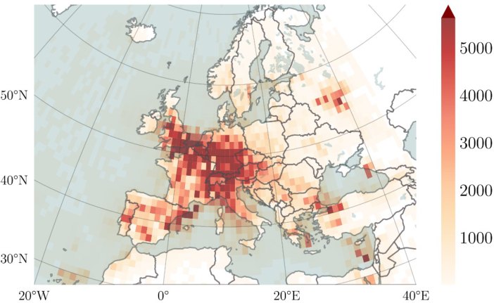
Figure 1: Geographical distribution of determined air traffic controller communication.
Figure 1 shows the geographic distribution of identified points where com- munication between an air traffic controller and a pilot was likely to have occurred. The geographical distributions according to the individual criteria are not shown here, but they are coherent with each other.
The modelling results show, that relatively large areas with a high coor- dination effort for air traffic management controllers exist in Europe. These areas are mostly located in Central Western Europe and UK, but also in Spain, Portugal and Russia, inter alia. In reality, the coordination effort is probably even higher than in this model. On the one hand, this is because not all ADS- B signals from aircraft may be detected by the network. On the other hand, the three selection criteria only consider certain air traffic controller activi- ties. This could be improved by using more criteria. Nevertheless, the model shows the relative distribution well.
CONCLUSION
In this paper, we investigated the potential for employing artificial intelli- gence (AI) systems in air traffic management. Therefore, radar data from European airspace operations was used to determine the coordination effort of air traffic controllers. For this purpose, data collected by a network of ADS-B receivers was analysed. The data was processed and analysed with three selection criteria regarding the effort of air traffic management. In this way, a spatio-temporal cadastre was created in which events leading to coor- dination effort are stored. A visualization of the modelling results shows, that relatively large areas with a high coordination effort for air traffic manage- ment controllers exist in Europe. These areas are mostly located in Central Western Europe and UK, but also in Spain, Portugal and Russia, inter alia. In reality, the coordination effort is probably even higher than in this model.
278 Holzenkamp and Jung
Against this background, it is reasonable to conclude that the potential for using AI in air traffic management is rather high and that the use of AI can be beneficial for ATM operations in Europe.
The cadastre will be used in the further progress of the DLR LOKI project to train and test air traffic controllers on AI in practice. Further work could improve the results by developing and applying additional criteria. New types of data could also be used for this purpose. An example of a new selection criterion would be comparing the trajectory flown with the trajectory origi- nally planned as deviations of an aircraft from the planned route indicate that communication between the pilot and the responsible controller has taken place.
REFERENCES
Bentley, J. L. (1975). A Survey of Techniques for Fixed Radius Near Neighbor Searching. Chakrabarti, S., & Vela, A. E. (2020). Clustering Aircraft Trajectories According to
Air Traffic Controllers’ Decisions. 2020 AIAA/IEEE 39th Digital Avionics Systems Conference (DASC), 1–9. https://doi.org/10.1109/DASC50938.2020.9256779 Chalela, M., Sillero, E., Pereyra, L., Garcia, M. A., Cabral, J. B., Lares, M., & Merchán, M. (2021). GriSPy: A Python package for fixed-radius nearest neighbors search. Astronomy and Computing, 34, Artikel 100443, 100443. https://doi.org/10.1016/j.ascom.2020.100443 Deutsches Zentrum für Luft- und Raumfahrt e.V. (2022). Das DLR. https://www.dlr.de/DE/organisation-dlr/das-dlr/das-dlr.html Olive, X. (2019). traffic, a toolbox for processing and analysing air traffic data.
Journal of Open Source Software, 4, 1518. https://doi.org/10.21105/joss.01518 Olive, X., & Basora, L. (2019). Identifying Anomalies in past en-route Trajectories with Clustering and Anomaly Detection Methods. ATM Seminar 2019. https://hal.archives-ouvertes.fr/hal-02345597 Rantanen, E. M., & Nunes, A. (2005). Hierarchical Conflict Detection in Air Traf-
fic Control. The International Journal of Aviation Psychology, 15(4), 339–362. https://doi.org/10.1207/s15327108ijap1504\_3
LISTED IN THE AHFE DIGITAL BOOKSTORE CATALOGUE
Explore the complete digital volume
Human Interaction and Emerging Technologies (IHIET-AI 2023): Artificial Intelligence and Future Applications
Read this individual research paper free through the original publisher, or explore the full digital proceedings book.
ISBN 978-1-958651-46-9
Explore this ISBN in the AHFE Bookstore ↗Listed in the July 2026 bookstore catalogue; search by ISBN to confirm current availability · Digital book purchase optional