Maria Isabel Romero, Laura De Jesús Calero Proaño, Maria Pin (2022). Territorial strategic plan focused on the sustainable urban-environmental micro-zoning of the Puerto Jeli parish, Santa Rosa canton, Ecuador 2021. In: Human Factors in Architecture, Sustainable Urban Planning and Infrastructure. AHFE Open Access, vol. 58, pp. 346–353. https://doi.org/10.54941/ahfe1002371
In recent years, research has been carried out related to territorial and urban planning in municipalities of Ecuador. However, there are still municipal organizations that have neglected urban parishes, ignoring places frequented by tourists and local citizens, such as Puerto Jelí, recognized for its gastronomy, high economic potential and tourist opportunities. The present work focuses on developing an essential structure based on an urban-environmental micro-zoning that results in ordering the territory of the study sector in an integral way under sustainable development guidelines, which will allow the development of the strategic plan to enhance the process of making and improve the quality of life of the inhabitants as an agent of exchange of goods and services, wealth creation, innovation and development.
Urban territorial planning in Latin America has historically influenced rural are-as, giving way to an uncontrolled concentration of cities (Sánchez, Hecha- varría, and Portilla, 2021), because urban sprawl has increased considerably, doubling in Ecuador due to the inadequate choice of growth and develo- pment actions (Valero and Hechavarría, 2020), as the migration rural-urban has led to settlements untidy, the depletion of natural resources, environmen- tal destruction and changing ecological systems (Cadena et al. 2021), thus, inadequate territorial planning has had significant, even negative, environ- mental impacts due to rapid urban growth (Alava, Hechavarría and Fois, 2020). In Ecuador, territorial planning is a controversy issue in years ago that has undergone a profound transformation until today and in a large part of the cities and parishes it has practically been null, due to the fact that the decisions with respect toplanning that have been made have been of free will by the competent authorities. The transformation of planning has been largely a consequence of advances in the development of social movements (Benabent and Vivanco, 2019).
Territorial Strategic Plan Focused on the Sustainable Urban-Environmental 347
That is why In the Puerto Jeli parish strategic plans have not been deve- loped that focus on zoning or micro-zoning that organize the territory in a sustainable way directed to the urban and environmental part where the lack of interest that has existed by parts of previous authorities, in the present you can notice an advance in wanting to change this situation.
On the other hand, when talking about sustainable development, we talk about actions that meet the current needs of humanity, without reducing the well-being of future generations (Fernández, 2013), being that urban areas focused on sustainability can be considered as opportunities for social and economic development, taking ad-vantage of the efficient use of resources, since in the globalized world, cities must be oriented towards a model that promotes overcoming deficiency and problems. , recognized by governments and society itself, linked to: high population growth, inequalities in access to services, housing and decent employment, the decline in the quality of life in cities, and the uneven and deteriorated areas, with levels of socio-natural risk that have not been adequately ad-dressed (Vásquez, 2014).
This document compiles information on how to create a territorial strate- gic plan focused on the sustainable environmental urban microzoning from Puerto Jeli that will allow analyzing its impact within the study area where the improvement of the population’s living conditions is seen, the tourist destina- tion, its economic reactivation, which is an entity for economic revitalization, taking ad-vantage of the position of the parish as a gastronomic center in the province and throughout the country, in this way it contributes positively to urban-environmental development taking into account criteria of territo- rial planning which guarantee sustainability which takes importance in the canton that is in the process of development.
MATERIALS AND METHODS
Territorial Planning In COOTAD, territorial planning constitutes a set of political orientati- ons that allow adequate territorial development, as well as the concept of planning for its management, taking into account the autonomy of the auth- ority, based on the recognition and appreciation of cultural diversity. and anticipation of socioeconomic and social realities (COOTAD, 2019).
The planning and implementation of the plans are focused on improving the indicators of quality of life and the principles of social and environmental functioning that the territory must comply with. In this sense, progress is being made in the search for tools for the organization and adaptability of strategic planning to management, as a process of obtaining, reproducing and organizing information on the global strategy used (Alencastro, Castañón, Quiñonez and Egas, 2020).
The territorial ordering of regions, provinces, departments, states and/or countries is intended to complement economic, social and environmental planning with a territorial dimension; rationalize interventions in the terri- tory; and guide its development and sustainable use, which is why in order to regulate order, permissive rules must be established regarding land use (Asamblea Nacional de Ecuador, 2010).
348 Romero and Calero
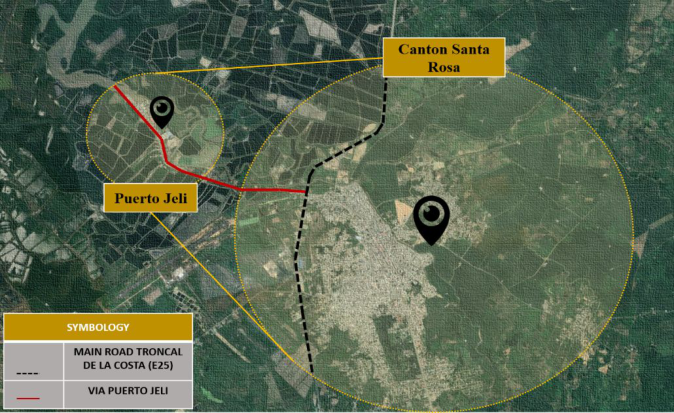
Figure 1: Puerto Jeli Parish and Santa Rosa cantonal head, delimited by its road axes. Source: image of google earth and own schematization.
Microzoning Microzoning in urban strategic plans is a technical tool aimed at improving the land, which helps organize the activities that people carry out on a daily basis. To microzonify it is necessary to analyze different aspects of the terri- tory, such as uncontrolled activities that cause environmental irresponsibility, pollution and open-air dumping, promoting the investigation of geographi- cal spaces to provide better alternatives that improve the quality of life in the study area (Mustoni, Carrizo, Pirrone, Orelo, Bernal, 2016).
When zoning is associated with the environment, it should be considered as the basis for a better use of spaces, territorial planning and holistic envi- ronmental management that link populations with natural resources to seek the optimal balance for society.
Delimitation of the Study Area The Puerto Jeli urban parish is located in Ecuador, province of El Oro (see Figure 1), northwest of the cantonal head of Santa Rosa, 5 kilometers from the central area. The entrance to this place is established in a north-south direction, taking as a reference the entrance to Santa Rosa from the city of Machala through Axis E25, passing the bridge over the Santa Rosa River, turning right of the roundabout to Mr. George Kaiser (Egas, 2015).
The Puerto Jeli parish limits to the north: Jelí River, south: Santa Rosa, east: mouth of the Pital River in the Jelí River, west: Branch of the Jelí River. This place is a tourist and gastronomic meeting point where there are varieties of sea-food restaurants, since its ancestral beginnings it has been dedicated shrimp activity and artisanal fishing with traditional techniques with little technological development which are part of the economic development of the citizens of this sector.
Territorial Strategic Plan Focused on the Sustainable Urban-Environmental 349
Case Study Being a global study that would directly and indirectly affect the inhabitants of the city of Santa Rosa both in the urban and rural sectors; Sampling refers exploratory and descriptive cross-sectional non-experimental design where the proposed research variables will not be manipulated, but rather an ove- rview of the state of one or more processes of phenomena, people, indicators that affect in the sector of study at a certain point in time, such as they arise in the urban-environmental, and transactional type, since it consists of the collection of current data in real time and also descriptive exploratory type because it will be carried out in different phases taking into account that within the strategic plans of the territory they will be projected as a series of processes participatory developed in phases: the first phase: planning or preparation, the second phase gathering information on site and the third phase: tabulation of the information obtained, graph and analysis of the data obtained.
Analysis of the Study Sector In the analysis of the study sector, the observation method was applied through the application of observation sheets where the problems that the population has could be evidenced and allowed to assess the basic services, equipment and infrastructure with respect to the study sector.
The study sector covers 300 families, where it was possible to collect infor- mation regarding the service situation of the Puerto Jelí parish, among other data that was collected from the reports of previous studies carried out.
RESULTS AND DISCUSSION
Territorial planning is projected as a participatory process that can be developed in stages such as: First phase: review of documentation, macro plans, pilot plans, direction of SENPLADES, municipal documentation, cadastres, theses, and diagnoses carried out. This information, once collected, must be analyzed to define the documentation and timely guide for the problems of the sector.
The direction of SENPLADES (National Planning and Development Secre- tariat), which promotes inclusive planning, embodied in the territories through de-concentration, decentralization and citizen participation (Gobi- erno de la Republica del Ecuador, 2021), it can be evidenced that within the Municipal Gad they do not guarantee territorial equity, therefore the study sector does not reach the standards of quality of life and does not achieve good living, lack of optimization efforts for the resources of the territory, there is no planning total with territorial vision.
The second phase: collection of data and physical and digital information obtained through the Municipal Gad, cartographic and geographic informa- tion that is where the database of the census sectors is obtained, in the field investigation observation sheets were used where obtained information on the equipment and infrastructure in the study sector, a photogrammetric fli- ght that resulted in an orthophoto and digital elevation model of the area, and the digitization process began with the use of specialized software tools, finally quantifies land use, obtaining geographic information.
350 Romero and Calero
Table 1. Information required to collect cartographic information.
Table available in the original PDF paper.
Zones Information Habitable Zone Homes, residences, buildings Green Area Courts, recreational areas, parks Tourist Area Tourist attractions Commercial Area Commercial corridors, fishing areas, fairs Road Zones Surface of main roads, secondary roads and alleys Topography Visualize contour lines and generate an elevation model
Description of the study sector areas and their information collected on site. Source: self-made
An interview was conducted with the urban and environmental manage- ment authorities of the Municipal Gad and in the same way surveys were carried out among the citizens who have been chosen as a sample for the inve- stigation, the survey will allow measuring the level of perception of the population of Puerto Jeli on land use planning and the environment. For the sample design, sampling by stages was applied. Initially, stratified sampling was used, partitioned to the population of the canton by blocks, in order to randomly select the number of families according to the weighted weight of the population, once the number was determined. of families that will be needed by blocks, in order to work with the cartography by census zones and sectors to choose the homes of the families to be interviewed.
The results obtained from the application of the questionnaire are tabu- lated, to be processed and analyzed later, during the development of the cartography with the information collected and digitized, all the thema- tic maps were elaborated using the SIG application (Florez and Fernandez, 2017), with the corresponding databases. dynamic data on population, basic facilities, infrastructure and cadastral information, dynamic databases allow us to show the current state of the study area through graphic representa- tions of quantitative determinants that in many cases would not have been possible without the adoption of a system such as ArcGIS.
The third phase: It consists of a proposal phase, mainly in the constru- ction of scenarios, which is nothing more than the configuration of territorial planning alternatives that will allow the established objectives to be achieved, where its recommended development is: define policies and scenarios; which can be an ideal and modern model; determine strategic planning objectives; contemplate goals that support the objectives.
The environmental approach will be implemented at this stage, since it is at this stage where the future of the territorial growth of the population is directed and this must be incorporated into goals and objectives where the indicators that can be considered are: habitat and housing, health , education, transportation and accessibility, drinking water, wastewater sanitation, solid waste management, commercial projection, tourism.
Proposal After evidencing the problem in the study sector causing a negative impact within the parish that is reflected in the lack of planning, under continuous
Territorial Strategic Plan Focused on the Sustainable Urban-Environmental 351
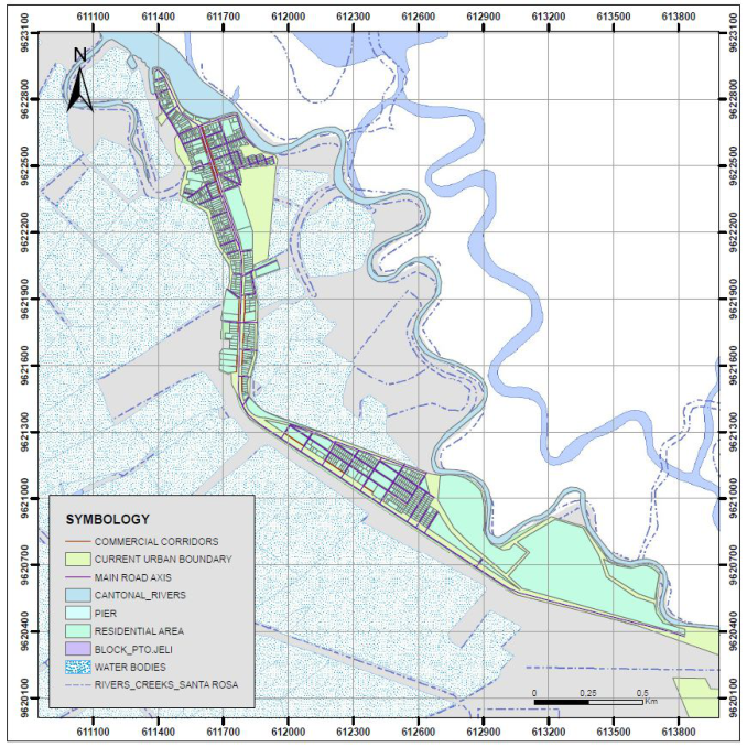
Figure 2: Urban-environmental microzoning map of the Puerto Jeli parish within the Santa Rosa canton. Source: self-made.
progress of the city, urban-marginal settlements, roads in non-optimal con- ditions for circulation, informal commerce , lack of services, problems of insecurity, productive characteristics of the sector, characteristics of the territory and the environment, etc.
Having said all this, the proposal (see Figure 2) is based on creating a stra- tegic territorial plan focused on an urban-environmental microzoning of the territory that allows the territory to be ordered in a certain way.
CONCLUSION
After having analyzed the results obtained in the applied surveys, it can be concluded that the inhabitants of the sector feel the deficit caused by the abse- nce of territorial planning and their interest can be evidenced because this situation changes in order to improve their living conditions, that is why cre- ating these strategic plan focused on urban and environmental development will generate opportunities for economic and social development.
352 Romero and Calero
Through the analysis of the variables, it was also possible to verify the importance of the execution of the microzoning, which will be a way of orde- ring the territory, taking advantage of the tourist and gastronomic potential of the sector that will help sustainable development where the benefits that would be obtained will be of importance for the economy and production of this area improving the quality of the service and therefore an effective demand that will be the opportunity to promulgate sustainable tourism as a tourist power of great importance. It can be shown that citizen participa- tion works as an important factor when planning to order the territory, since people are important elements of the territory, their effective participation provides inputs that, when validated, allow the identification of strengths and weaknesses of the parish.
ACKNOWLEDGMENT
First of all, we thank God for the opportunity he has given us to be part of this important project that will benefit the population of the Puerto Jeli parish, Santa Rosa canton. To our family for the support provided throughout this process; to the University of Guayaquil; to the Municipality of Santa Rosa, especially to the Territorial Planning Department of the Santa Rosa canton.
REFERENCES
Alava Portugal C., Hechavarría Hernández J., Fois Lugo M. (2020). Systemic Approach to the Territorial Planning of the Urban Parish La Aurora, Daule, Ecuador. In: Ahram T., Karwowski W., Vergnano A., Leali F., Taiar R. (eds). Intelligent Human Systems Integration 2020. IHSI 2020. Advances in Intelligent Systems and Computing, vol 1131. Springer, https://doi.org/10.1007/978-3-030-39512- 4_183. Alencastro F., Castañón J., Quiñonez M., Egas (2020), Planificación estra- tégica para el desarrollo territorial de la Provincia Esmeraldas vol. XXVI, pp. 130–147. (2020), In.:https://www.redalyc.org/jounal/280/28063519005/html /#redalyc_28063519005_ref5. Asamblea Nacional, Republica del Ecuador (2016) “Ley orgánica de ordenamiento
territorial, uso y gestión de suelo” In.: https://www.habitatyvivienda.gob.ec/wp-c ontent/uploads/downloads/2016/08/Ley-Organica-de-Ordenamiento-Territorial -Uso-y-Gestion-de-Suelo1.pdf Benabent M. (2016) “Teorías de la planificación territorial: métodos de decisión. ciudad y territorio, estudios territoriales,” pp. 353–368. In: https://recyt.fecyt.es/index.php/CyTET/article/view/76487. Cadena A., Espinoza F., Vega G., Hechavarria J. (2021) Community Management Model of Water Resources. Case Study: Urban Planning of the Vinces Canton, Ecuador. In: Karwowski W., Ahram T., Etinger D., Tankovi´c N., Taiar R. (eds). Human Systems Engineering and Design III. IHSED 2020. Advances in Intelli- gent Systems and Computing, vol 1269, pp. 239–244. Springer. https://doi.org/ 10.1007/978-3-030-58282-1_38. Egas L. (2015). Propuesta técnica logística para muelle pesquero y turístico de Puerto
Jelí en la ciudad de Santa Rosa, El Oro. Escuela de Ingeniería Civil. UIDE. Quito Campus Norte pp.162. In.: http://repositorio.uide.edu.ec/handle/37000/2151
Territorial Strategic Plan Focused on the Sustainable Urban-Environmental 353
Fernández L, y Gutiérrez M. (2013) Bienestar Social, Económico y Ambiental para las Presentes y Futuras Generaciones. Información tecnológica, 24(2), 121–130. In.: https://dx.doi.org/10.4067/S0718-07642013000200013. Flórez D., y Fernández D. (2017) Los Sistemas De Información Geográfica. Una Revi-
sión. Revista Facultad de Ciencias Agropecuarias-FAGROPEC, 9(1), pp. 11–16. In.: C:/Users/USUARIO/Downloads/347Texto%20del%20art%C3%ADculo- 1035-1-10-20210218.pdf Gobierno de la Republica del Ecuador, “Secretaría Nacional de Planificación,” (2021). In.: https://www.planificacion.gob.ec/la-secretaria/. Mustoni N.; Carrizo A.; Pirrone R.; Orelo G. ; Bernal Martínez A.; Sedevich A.,
(2016) “Propuesta de una microzonificación en el distrito El Algarroba, Micro- zoning proposal in El Algarrobal District,” In.: http://repositorio.umaza.edu.ar/h andle/00261/563 Presidencia de la Republica, Enrique H. (2019), Suplemento del Código orgánico de organización territorial, cootad, pp. 1–181, In.: https://www.cpccs.gob.ec/wp- content/uploads/2020/01/cootad.pdf. Sanchez Padilla M.., Hechavarria J., Portilla Castell Y. (2021): Systemic Analysis of
the Territorial and Urban Planning of Guayaquil. In: Ahram T., Karwowski W., Kalra J., (eds). Advances in Artificial Intelligence, Software and Systems Enginee- ring. AHFE 2021. Lecture Notes in Networks and Systems, vol 271, pp. 411–417. Springer. https://doi.org/10.1007/978-3-030-80624-8_51. Vásquez O. (2014) “La gestión urbana sostenible: conceptos, rol del gobierno local y vinculación con el marketing urbano” In.: https://www.redalyc.org/pdf/555/ 55532603006.pdf. Valero Fajardo C, Hechavarría Hernández J. (2020): PEST Analysis Based on Fuzzy
Decision Maps for the Ordering of Risk Factors in Territorial Planning of the Vinces Canton, Ecuador. In: Ahram T., Karwowski W., Vergnano A., Leali F., Taiar R. (eds). Intelligent Human Systems Integration 2020, Advances in Intelli- gent Systems and Computing, vol 1131, pp. 1190–1194. Springer. https://doi.org/ 10.1007/978-3-030-39512-4_181.
LISTED IN THE AHFE DIGITAL BOOKSTORE CATALOGUE
Explore the complete digital volume
Human Factors in Architecture, Sustainable Urban Planning and Infrastructure
Read this individual research paper free through the original publisher, or explore the full digital proceedings book.
ISBN 978-1-958651-34-6
Explore this ISBN in the AHFE Bookstore ↗Listed in the July 2026 bookstore catalogue; search by ISBN to confirm current availability · Digital book purchase optional