Diana Salinas, Jesús Rafael Hechavarría Hernández, Maria Pin (2022). Strategic urban mobility plan: Case study in the central area of Daule city, Ecuador. In: Human Factors in Architecture, Sustainable Urban Planning and Infrastructure. AHFE Open Access, vol. 58, pp. 240–246. https://doi.org/10.54941/ahfe1002357
In recent decades, urban mobility problems have increased in the city of Daule, Ecuador, due to the indiscriminate growth of the central zone. These problems are due to vehicular congestion and negative social and environmental impacts on the quality of life and the deterioration of the urban image caused by the increase in motorized transport. The urban mobility model that is presented seeks to contribute to sustainability and increase safety through a strategy that promotes public transport and non-motorized transport based population's displacement needs and care of the environment. The research design is exploratory and descriptive based on quantitative and qualitative analysis of the appearance and diagnosis of the general characteristics of the sector. The graphic results are obtained with ArcGis where Jan Gehl's methodology on urban architecture is applied, which allows considering the human dimension of public space according to the scope B-Sustainable Mobility.
Mobility in cities is increasingly dependent on the use of private vehicles; which produces serious problems (León and Carriel, 2021), such as: social, economic, environmental changes and therefore negative effects on the qua- lity of life of people (Kiba-Janiak and Witkowski, 2019). In recent years there has been a progress from the concept of transport to that of mobility, as part of a transformation to reach sustainability and integrated traffic planning (Hermida, 2016). At the local level, initiatives have been taken for the deve- lopment of sustainable urban mobility; the National Plan for Good Living establishes that urban planning should be improved in terms of road safety, development of decent public transport and non-motorized means of mobi- lity (Consejo Nacional de Competencias Nacional [CNC], 2014). In this way, the Ministry of the Environment in 2019 published the elaboration of the National Plan for Sustainable Urban Mobility whose objective is to reduce greenhouse gas emissions from transport, since they represent 40% of the total (Ministerio del Ambiente, 2019).
Strategic Urban Mobility Plan: Case Study in the Central Area of Daule City, Ecuador 241
In cities such as Guayaquil and Milagro, new studies related to urban mobility have been carried out where sustainable solutions are promoted for pedestrians and cyclists, allowing them to improve their accessibility in public space (Perez et al. 2021), (Avila et al. 2020), in addition to alternatives to improve the development of public transport (Orozco and Hechavarría, 2020). In the case of Daule, the mobility problem has increased in recent years. A recent study carried out in the center of Daule reveals the lack of planning in terms of land use and urban mobility, which prevents sustainable urban development (Castro et al. 2020).
The objective of the present work is to elaborate a proposal under sustai- nability parameters that allows ordering the mobility of the sector, to mitigate the increase in vehicular congestion and environmental pollution, where the pedestrian is the main actor in the development of urban displacement; which will allow to improve the lifestyle, have better connectivity and therefore guarantee an integral development.
MATERIALS AND METHODS
Delimitation of the Study Area The Daule canton is located in the center-south of the Litoral region, it repre- sents the fourth largest and most populous city within the province of Guayas and is called the rice capital of Ecuador due to the important production and commercialization of this product (Plan de Desarrollo y Ordenamiento Ter- ritorial del Cantón Daule [PDyOT Daule], 2015), (Municipalidad de Daule). Its geographical coordinates are −1.8667 South latitude, −79.9833 West lon- gitude, it is between 15 and 58 meters above sea level (Castro et al. 2020) and has a population of 120326 inhabitants (Municipalidad de Daule). The study area is comprised of 38 blocks, 29 corresponding to the Downtown area and 9 corresponding to the Cantonal Head Neighborhood of the city of Daule.
Methodology
The type of research design that was selected was exploratory and descriptive, using quantitative and qualitative tools for data collection such as: observa- tion sheets, photographs, surveys and noise measurement. This allowed the analysis and diagnosis of the aspect and general characteristics of the sector, especially the elements that determine the development of urban mobility. To obtain an inventory of the evaluation of the sector, an analysis was carried out by means of direct observation. The summary of the specific characteristics of the sector is presented in Table 1.
The evaluation was complemented with the methodology sheets of the human dimension in the public space of the architect Jan Gehl, in the field of sustainable mobility. Where the parameters that are evaluated are: pedestrian experience that determines walkability; experience for cyclists that determi- nes the infrastructure for cycling; public transport service that determines if it exists, if it is of high efficiency and low environmental impact; and registration of pedestrians and cyclists that determines the demand for them
Table 1. Summary files downtown area and cantonal header. (Source: self-made).
Table available in the original PDF paper.
Parameter Downtown area Cantonal Header Neighborhood Land Use Mixed (residential and commercial) Residential, Mixed (residential and com-mercial) Basic Infrastructure Good Good Type of transport Private vehicle, Tricimotos, Transportation of products
Secondary pathways
Private vehicle, Tricimotos, Transportation of products Road infrastructure Good Good Way Hierarchy Private pathways Secondary pathways Does not have Does not have Infrastructure for cyclists
Cycling experience Does not have bike lanes Does not have bike lanes Public transport service and taxis
Does not have local routes It has intercantonal buses It does not have bus stops High influx of pedestrians High influx of cyclists
Regular influx of pedestrians Low influx of cyclists
Does not have local routes It has intercantonal buses It does not have bus stops Registration of Pedestrians and cyclists
(Gobierno de Chile, PNUD, 2017). The data was plotted in ArcGis and the summary is presented in Table 2.
To carry out the analysis of the needs of the population regarding urban mobility, surveys were used, which consist of 20 questions focused on obtai- ning information regarding: population data, main activities of the sector, types of transport, quality of road infrastructure, accessible public spaces, environmental impact and pollution in the city.
The sample size for the surveys was obtained using the conventional for- mula for finite population. There were 388 surveys, considering a population of 37,000 inhabitants, applying a confidence level of 95% (1.96) and a sam- pling error of 5% (0.05). The survey was carried out using the QuestionPro platform.
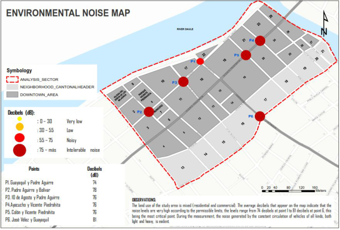
To identify the critical points with the greatest environmental noise, the measurement was carried out with a sound level meter and the permissible
Strategic Urban Mobility Plan: Case Study in the Central Area of Daule City, Ecuador 243
Figure 1: Map of representation of decibels streets Bolívar, 10 de Agosto, Guayaquil, Colón, Ayacucho and avenue Piedrahita. (Source: self-made).
levels were considered according to the national technical standard Mini- sterial Agreement 097-A TULSMA BOOK VI, Annex 05, guidelines of ISO 1996-1, ISO 1996-2 that is issued under the protection of the Environmental Management Law. The results were presented spatially on a map using the ArcGis tool (see Figure 1).
PROPOSAL The Strategic Urban Mobility plan in the central area of Daule city focuses on promoting the use of public transport and the use of non-motorized means, through the regulation of informal transport and the pedestrianization of the streets of the historic center, implementing pedestrian accessibility under equity parameters, safely and without obstacles. In this way it will be possible to achieve an automatic and efficient management that allows optimizing the traffic.
This model is not only focused on the efficiency of the types of transport, but also takes into account the displacement needs of the population and its relationship with the environment and the social, spatial, economic and institutional structure of the territory.
Regulation of Informal Transport The regulation of tricycles by motor traction is composed of a series of inte- rventions and projects that will allow their sustainable development, which are named below.
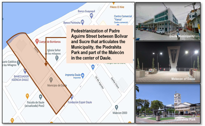
Figure 2: Location of streets for pedestrianization. (Source: self-made).
Route study project for Tricimoto public transport.
Ordinance where the official collection rates for Tricimotos are established.
Bi-annual vehicular technical review law for Tricimoto public transport.
Study for the creation of passenger stops for public transport in Tricimoto, to obtain a more orderly and better planned mobility.
Maintenance and reconditioning of the roadway and signage on the routes for public transport.
Construction of Stations for Tricimoto public transport: it consists of cre- ating standard stations that can be located at strategic points with an adequate radius of action to satisfy the needs of users in the city center. This project was born as a response to the problem of public space invaded by the traffic of tricimotos, preventing proper enjoyment by pedestrians, degrading the image of the city and causing vehicular congestion in some cases.
Pedestrianization of Padre Aguirre Street Between Bolívar and Sucre The pedestrianization project will be developed in the center of Daule on Padre Aguirre streets between Bolívar and Sucre to articulate the surroun- dings of the Municipality with the Piedrahita park and part of the Malecón, this idea arises in the first instance as an improvement of the functional aspect of the streets, as a strategy of moderation of traffic and to promote the accessibility of the pedestrian within the historic center of the city.
Pedestrianization projects seek to optimize sustainable urban mobility and improve physical aspects of the street. In general, this process begins in the historic centres, seeking the conservation of heritage, the relationship and social interaction, the increase in safety while improving functional aspects.
Strategic Urban Mobility Plan: Case Study in the Central Area of Daule City, Ecuador 245
RESULTS
As a general result, it was possible to determine the lack of a sustainable urban mobility policy in the central part of the city of Daule, the little linkage of sectoral integrity and coordination between the planning of the urban system and the public transport service. The spaces that people occupy in the center of the city of Daule lack adequate accessibility and fluid and safe mobility for social development, hence the need to intervene with grounded urban projects that favor the development of the human being in space.
Through the observation sheets and Jan Gehl’s methodology, the lack of infrastructure and spaces for pedestrians and cyclists was evidenced, which should be the main protagonists within sustainable mobility. Sustainable mobility reduces road accidents, increases energy efficiency, improves air quality, prevents social and labor exclusion and mitigates climate change.
The noise measurements allowed a correct diagnosis regarding the envi- ronmental impact caused in the sector, in this way the increase in informal transport and the transport of products can be solved in a timely manner.
Through the surveys it was possible to identify the needs of the popula- tion in terms of movement within the city, in addition to the lack of road infrastructure and the lack of public spaces for citizens.
Regarding the potentialities that exist in the territory, it can be highlighted that the central part of the city of Daule has all the basic infrastructure, such as: electricity, drinking water, garbage collection and sewage. In addition, work is being done on the regeneration of some roads and sidewalks.
CONCLUSION
Through the study carried out, it is concluded in a general way that the pro- posal rep-resents the best measure to mitigate the effects of urban mobility congestion in the center of Daule, based on sustainability parameters, which reduce the environmental and social impact allowing the development of a prosperous community.
The planning of urban roads proposed in the plan will allow the reco- very of public spaces where the pedestrian is the main user, promoting unity and social equity. In addition, sustainable urban and territorial development approaches should be considered, integrated and inclusive that take into account all people without distinction of age, gender, social status or any disability, through the application of policies and the formulation of specific strategies.
REFERENCES
Avila, J., Fois, M. and Hechavarría, J. (2020) ‘Strategies for Accessibility to the Teodoro Maldonado Hospital in Guayaquil. A Design Proposal Focused on the Human Being’, in Ahram, T. et al. (eds) Intelligent Human Systems Integration 2020. Cham: Springer International Publishing, pp. 1256–1262. Castro, D., Vega, G. and Hechavarría, J. (2020) ‘Proposal for Integration of Urban
Planning with the Environment in Daule - Ecuador’, in Karwowski, W. et al. (eds) Advances in Physical, Social Occupational Ergonomics. Cham: Springer International Publishing, pp. 468–474.
Consejo Nacional de Competencias Nacional CNC (2014) Guía metodológica para la formulación de planes de movilidad para los gobiernos autónomos descentrali- zados municipales del modelo de gestión. Website: http://www.competencias.gob .ec/wp-content/uploads/2015/04/guia_noviembre.pdf Gobierno de Chile PNUD (2017) La dimensión humana en el espacio público, Serie
Espacios Públicos Urbanos. Ministerio de vivienda y Urbanismo de Chile. Website: https://www.minvu.cl/wp-content/uploads/2019/08/La-dimension-humana.pdf Hermida-Palacios, C. (2016) ‘Del Transporte a La Movilidad’, DAYA. Diseño, Arte y Arquitectura., 1(1), pp. 20–35. doi: 10.33324/daya.v1i1.5. Kiba-Janiak, M. and Witkowski, J. (2019) ‘Sustainable urban mobility plans: How
do they work?’, Sustainability (Switzerland), 11(17). doi: 10.3390/su11174605. León, M. and Carriel, V. (2021) ‘Indicadores para medir la movilidad sostenible en espacios urbanos de la sierra ecuatoriana. Caso de estudio el cantón Azogues’, ConcienciaDigital, 4(1.2). doi: 10.33262/concienciadigital.v4i1.2.1738. Ministerio del Ambiente, A. y T. E. (2019) Ecuador trabaja en la ela- boración del Plan Nacional de Movilidad Urbana Sostenible, Ministerio del Ambiente, Agua y Transición Ecológica- Comunicamos-Noticias. Web- site: https://www.ambiente.gob.ec/ecuador-trabaja-en-la-elaboracion-del-plan-n acional-de-movilidad-urbana-sostenible/ Municipalidad de Daule., Datos generales. Website: https://www.daule.gob.ec/web/g
uest/datos-generales. Orozco, F. and Hechavarría, J. (2020) ‘Improvement of Public Transport Routes with ArcGIS Network Analyst. Case Study: Urban Center of Milagro, Ecuador’, in Charytonowicz, J. (ed.) Advances in Human Factors in Architecture, Sustaina- ble Urban Planning and Infrastructure. Cham: Springer International Publishing, pp. 31–36. Pérez, A., Leyva, M. and Hechavarría, J. (2021) ‘Pedestrian Traffic Planning with
TOPSIS: Case Study Urdesa Norte, Guayaquil, Ecuador’, in Ahram, T. et al. (eds) Human Interaction, Emerging Technologies and Future Applications III. Cham: Springer International Publishing, pp. 69–76. Plan de Desarrollo y Ordenamiento Territorial del Cantón Daule 2015-2025.
Human Factors in Architecture, Sustainable Urban Planning and Infrastructure
Read this individual research paper free through the original publisher, or explore the full digital proceedings book.
ISBN 978-1-958651-34-6
Explore this ISBN in the AHFE Bookstore ↗Listed in the July 2026 bookstore catalogue; search by ISBN to confirm current availability · Digital book purchase optional