Danny Macías, Jesús Rafael Hechavarría Hernández, Lorena Sánchez (2022). Master plan of green areas for the conformation of public spaces after the COVID-19 pandemic. Case study: Isidro Ayora canton, Guayas, Ecuador. In: Human Factors in Architecture, Sustainable Urban Planning and Infrastructure. AHFE Open Access, vol. 58, pp. 189–196. https://doi.org/10.54941/ahfe1002351
In the cities of Ecuador, the green area and public spaces are very important for recreation, interaction with people and the enjoyment of nature. The COVID-19 pandemic has generated significant changes in urban planning when considering green areas and public spaces according to the new demands of distancing for the population. The objective of the research work is to propose the master plan of green areas for the northern area of the cantonal head of Isidro Ayora, as a strategy for the conformation of the public space of free access to the population according to post-pandemic guidelines. The proposal is developed in La Ciénega, located in the northeast of the cantonal head, which is a land declared as a protected area by the Guayas provincial government. From the method of observation, surveys and the use of geographic information programs, the research methodology will be developed that includes: statistical analysis of 198 people according to a sample calculated with the INEC projection, diagnosis of the study sector and development of the intervention polygon through ArcGIS based on results.
For decades and continuously, the interaction of the population with nature has deteriorated, this problem being more evident in the cities where the majority of the population currently lives. According to the World Bank (Banco Mundial, 2020), about 55% of the population lives in cities with a tendency to increase, estimating that by 2050, 7 out of 10 people will live in urban centers and perimeters. For this reason, it is essential to set new obje- ctives for a comprehensive and efficient management of urban planning and of territories in general, where green public spaces are decisive in the restru- cturing of the trend and growth of cities (Segarra et al. 2021). The mentioned criteria must be considered since the few existing recreation areas are incre- asingly crowded by citizens, evidencing the need to implement free access spaces with vegetation (Salinas et al. 2020) that mitigate the different envi- ronmental consequences of higher density urban areas. such as heat islands,
loss of air quality, decreased well-being of citizens, environmental pollution, among others (Arreaga et al. 2020).
This is how public green areas have become essential for urban develo- pment to be considered suitable and sustainable. Squares, parks and urban vegetation not only make the city more attractive, but also improve the quality of life of the citizens who live there (BID, 2020). This is because it generates an environmental balance between nature and the urban fabric. The latter term is defined as a concept that has generated interest in urban planners after the outbreak of the COVID-19 pandemic, a situation that made it necessary to take health measures of social distancing as a key to lower the rate of spread of the virus, facing us to reality and what is complicated for a large part of the population. In particular, the part of the population that lives in informal settlements, mostly without provision of drinking water, sewage, green public space, that is, with poor living conditions, are more propitious for the transmission and spread of the virus (Rodríguez et al. 2021). In this way, it is possible to substantiate the essential need for citizens to have quality green areas and public spaces, aligning with the post-pandemic urban reality.
It is also essential to create an ecological awareness in the population that allows contributing to a responsible management of environmental resources that contribute to a direct interaction with nature (García et al. 2020). Deve- lopment, territorial planning, and green areas are the main axes that seek to improve the quality of life of the population (Alava et al. 2020). In addition, developing a strategic plan for green areas that promotes sustainable solu- tions in the design of cities (Toapanta et al. 2021). Is key and necessary to increase the urban green index and, in turn, generate a positive influence in the community by making good use of the advantages and resources provi- ded by nature. This is how the importance of public places of recreation is considered as the objective of the investigation, and a general scheme of inte- rvention is proposed when implementing a master plan of green areas for the northern zone of the cantonal capital of Isidro Ayora of the Guayas Province of Ecuador. This is focused as an urban planning strategy in sight of the city growth rate in which the creation of green public space with free access to the population must be guaranteed, based on the criteria dictated today by the Covid-19 pandemic.
MATERIALS AN METHODS Delimitation of the Study Area
The Isidro Ayora Canton is located in the northwest of the province of Guayas, in the Ecuadorian coastal region. It has a population of 14,582 inhabitants, according to the projection to 2020 of the last national popu- lation and housing census, with a cantonal growth rate of 3.10%. The area is 491.16 square kilometers as determined by the Technical Secreta- riat of the National Committee of Internal Limits (CONALI, 2015) when issuing the reasoned technical report of territorial delimitation which curren- tly governs, and the gross population density is 29.69 inhabitants per square kilometer.
Master Plan of Green Areas for the Conformation of Public Spaces 191
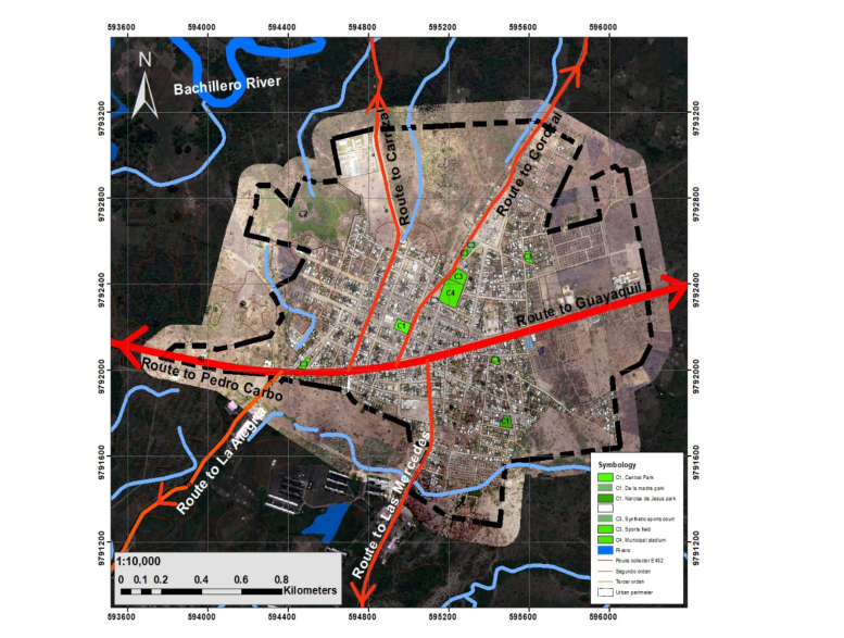
Figure 1: Map of the current situation Isidro Ayora canton.
Case Study Currently, the Isidro Ayora Canton is characterized by having a higher percentage, specifically 75.57%, of its territorial extension with use of prote- ction and conservation, according to what is indicated within the Territorial Planning and Development Plan of the canton (PDyOT Isidro Ayora, 2015). However, when considering that the World Health Organization WHO (INEC, 2016) established green surfaces between 10 and 15 m2 per inh- abitant and an urban design that incorporates a network of green spaces accessible up to 15 minutes on foot from the houses, there is clear evide- nce of a green area in the cantonal capital deficit. This phenomenon was generated by the accelerated annual increase in population and the growth of urban sprawl. The sector to intervene is located in the northwest area of La Ciénega Canton, which is an extension of peri-urban territory that was declared a protection zone by the Provincial Government of Guayas, due to its great landscape and ecosystem environmental value (see Figure 1).
Description of the Method and Design The sector to be intervened corresponds to the northern area of the Isidro Ayora canton. The limits were taken from the analysis carried out on the site defined as a peri-urban sector, where the urban layout is significantly separated from the natural territory.
To achieve the proposed objectives, the analysis area was delimited within the sector to be intervened. The layout and the fabric were analyzed on the satellite image of the Isidro Ayora Canton provided by Google Earth, developed in ArcGIS.
For the definition of the northern peri-urban area, the delimitation of the existing neighborhood was used as a basis, which at first glance are rela- tively homogeneous in terms of layout and urban fabric. In this case, the homogeneity is less in the urban-natural interface area, forming a productive ecological landscape.
For purposes of determining the index of existing green areas in the canton, two types of methodology were used: descriptive and analytical. The first is the descriptive methodology that consisted of a sectoral visual analysis of the consolidated urban area, a tool through which two points were defined. The first point is the homogeneous urban units by their land use, these being residential, commercial and administrative to define the concentration and density of people. As a second point, the identification of each of the existing green surfaces within the urban fabric of each block was carried out in order to later be classified according to the existing percentage of green area in the intervention sector.
In the analytical methodology, quantitative tools were used, such as surveys carried out on the 198 people who are part of the calculated sample of the population of the sector to be intervened, where precise information was obtained from the inhabitants about the need for the implementation of public green spaces in the focused sector.
Analysis of Environmental Indicators For the selection of the environmental indicators and, considering the resou- rce and distribution of the existing ecological elements in the sector to intervene that allow the increase of public green spaces and the growth of the vegetation cover in the analysis areas, the following indicators were considered:
- Indicator 1: Public green area per inhabitant that allows quantifying the extension of existing public green areas in relation to the number of inhabitants.
- Indicator 2: Layout of the public green area that allows assessing the contribution percentage of each zone in the total area of green areas as public space.
- Indicator 3: Non-waterproofed surface that allows quantifying the percentage of surface with non-waterproofed soil.
- Indicator 4: Index of existing vegetation that allows evaluating the surface of urban land covered with vegetation in public and private spaces.
Through the analysis of indicator 1, the current assessment of existing public green space in m2 per inhabitant was obtained, evidencing the deficit in terms of the existence of green areas per inhabitant. In the same way, indi- cator 2, like the first indicator, allowed us to recognize the areas in which a greater extension of public green surface is concentrated, and this way deli- mit the intervention polygon that is developed in La Ciénega, located to the
Master Plan of Green Areas for the Conformation of Public Spaces 193
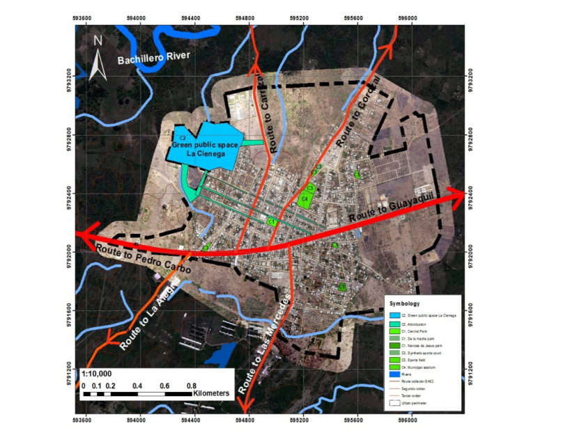
Figure 2: Map of intervention strategies.
northwest of the cantonal head. To assess both indicators, data provided by the PDyOT of the Isidro Ayora Canton and statistical data from the INEC were used.
For indicator 3, reference satellite images obtained from Google Earth were used, where the growth of the urban sprawl in the northern sector of the canton was analyzed, allowing the identification and grouping of built-up urban areas. Finally, indicator 4, which corresponds to the existing vegetation index, made it possible to locate and determine the percentage of green area in the sector. Indicators 3 and 4 show the location and distribution of unbuilt land covered by vegetation.
From the information obtained, it is evident that there is currently an approximate of 5.18 m2 of green surface per inhabitant, a value that shows the deficit in relation to what is recommended by international standards.
Intervention Strategies Through the master plan for green areas that allows the creation of public spaces after the COVID-19 pandemic, several intervention strategies have been considered to introduce nature into public spaces in the city, achie- ving positive changes in urban environmental conditions and in the quality of life, health, and comfort of the inhabitants. The strategies to be implemented include (see Figure 2).
1. Intervention of an area of 13.74 hectares of land in La Ciénega, located northwest of the cantonal capital. 2. Integration of the green concept as a fundamental element within the development plans and land use planning of the canton. 3. Implementation of a regulatory framework that regulates the standards of green areas. 4. Implementation of an urban tree-planting program. 5. Green infrastructure corridors that connect the existing public green spaces in the canton.
RESULTS
From the results obtained, it is determined that public green spaces are of great relevance and consideration within the territorial planning of the canton due to the functions of recreation and social interaction that they can generate among the inhabitants. Criteria evaluated by observing that, within the urban area, cen-tral and peri-urban areas, determine that where this particular place is developed, a dense urban fabric is developed without front setbacks, with un-waterproofed soil with little public green area.
As can be seen in the comparison of indicators, the areas with the largest amount of surface covered with vegetation are found on the outskirts of the can-ton. Showing that, in residential areas, there is a low density and a high percent-age of non-waterproofed soil caused by the lack of public green areas.
Likewise, it was observed that the highest percentage of green surface is developed in the northwest sector of the canton. Hence, the importance of deter-mining this polygon as a public green space in order to prevent it from being urbanized or built.
In this way, with the implementation of a Master Plan for green areas that al-lows the creation of public spaces in the Isidro Ayora canton, it is sought that by the year 2025 the goal is to have at least 9.00 m2 of green areas per inhabitant of the Isidro Ayora Canton. By also, aligning up with what is proposed within the Land Management and Development Plan of the canton in terms of green areas, thus improving the environmental and landscape conditions of the city’s urban space.
With the proposal for the creation of green infrastructure corridors that connect the existing public green spaces in the canton, the aim is to establish spaces or surfaces adjacent to the arteries of the city, creating wide green strips that im-prove public space and giving continuity and communication throughout the city areas designated for pedestrian traffic.
With the Integration of the green concept as a fundamental element within the development plans and land use planning of the canton, the aim is to create standards in the execution of green areas, taking into account the percentages of green surfaces, buildings, accessibility, urban furniture, among others.
With the proposal for the implementation of a regulatory framework that regulates the standards of green areas, the goal is to establish technical and legal considerations for the improvement and comprehensive management of existing public green spaces in the canton.
Master Plan of Green Areas for the Conformation of Public Spaces 195
With the proposal to implement an urban tree-planting program, planting criteria allow the incorporation of new plant species in green spaces in order to fulfill environmental, ornamental, and recreational functions is sought.
CONCLUSION
From the analysis carried out, it is concluded that the current urban layout of the Isidro Ayora Canton has a tendency to increase the urban area regarding the variables of occupation and land use. A minimum percentage dedicated to public space is also reflected due to the accelerated city growth model without an adequate application of territorial management instruments. As a result of the analysis carried out based on the parameters described, the existence and limitation of green areas in the Isidro Ayora Canton dedicated to public spaces is determined. The diagnosis allowed the development of a Master Plan for green areas that al-lows the creation of public spaces where the need to reverse the scarce green area is based, being a crucial variable in the care and protection of the environment. A management tool supported on GIS is obtained. It guides and enables the construction, fitting out, protection, and recovery of green spaces through a comprehensive management of territorial planning, according to the sustainability of the territory based on the Right to the City through citizen participation.
REFERENCES
Álava C., Hechavarría Hernández J.R. (2020). Proposal for a Green Area Master Plan. Case of Study: Nueva Aurora Cooperative, Daule, Ecuador. En: Charytonowicz J. (eds) Advances in Human Factors in Architecture, Sustainable Urban Planning and Infrastructure. AHFE 2020. Advances in Intelligent Systems and Computing, vol 1214. Springer, Cham. https://doi.org/10.1007/978-3-030- 51566-9_27 Arreaga G., Vega G., Hechavarría Hernández J.R. (2020). Proposal for a Master Plan of Green Area in the Second Step of the El Recreo Citadel, Canton Duran, Ecuador. En: Charytonowicz J. (eds) Advances in Human Factors in Architecture, Sustainable Urban Planning and Infrastructure. AHFE 2020. Advances in Intelli- gent Systems and Computing, vol 1214. Springer, Cham., https://doi.org/10.1007/ 978-3-030-51566-9_6 BID (Banco Interamericano de Desarrollo). (2020). Sustainable Cities. Public
space: 6 ideas to revitalize neighborhoods the day after COVID-19. Web- site: https://blogs.iadb.org/ciudades-sostenibles/es/espacio-publico-6-ideas-para -revitalizar-barrios-el-dia-despues/ Development Plan and Land Management Plan of the Isidro Ayora canton 2015–
2025. Website: http://www.isidroayora.gob.ec/gaceta.html#TWO García A., Pin R., Hechavarría Hernández J.R. (2020). Rural Tourism Development Proposal. Case Study: The Commune El Palmar, Santa Elena Canton, Ecuador. En: Kantola J., Nazir S., Salminen V. (eds) Advances in Human Factors, Busi- ness Management and Leadership. AHFE 2020. Advances in Intelligent Systems and Computing, vol 1209. Springer, Cham. https://doi.org/10.1007/978-3-030- 50791-6_10 National Institute of Statistics and Censuses, (2016). Inec. “Ecuador in figures,”
Website: In: https://www.ecuadorencifras.gob.ec
Rodríguez T., Birche, M., Cortizo, D. (2021). Analysis of public space in the face of the pandemic in an informal urbanization in Argentina. Urbanism Magazine, (44), 96–111. https://doi:10.5354/0717-5051.2021.58512 Salinas J., Vega G., Hechavarría Hernández J.R. (2020). Green Areas Plan with
Native and/or Endemic Plants for Mitigation of Heat Island in Letamendi Parish, Guayaquil. En: Charytonowicz J. (eds) Advances in Human Factors in Archite- cture, Sustainable Urban Planning and Infrastructure. AHFE 2020. Advances in Intelligent Systems and Computing, vol 1214. Springer, Cham., https://doi.org/10. 1007/978-3-030-51566-9_9 Segarra G., Torres M., González C. (2021). Urban Green System of Loja as a structuring base of the city of Estoa. Magazine of the Faculty of Archite- cture and Urbanism of the University of Cuenca. https://doi.org/10.18537/est.v01 0.n020.a05 Technical Secretary of the National Committee of Internal Limits (2016). In: https:
//www.gob.ec/conali Toapanta A., Leyva M., Hechavarría Hernández J.R. (2021) AHP Applied to the Prioritization of Recreational Spaces in Green Areas. Case Study: Urban Area of the El Empalme Canton, Ecuador. En: Ahram T. (eds) Advances in Artificial Intel- ligence, Software and Systems Engineering. AHFE 2020. Advances in Intelligent Systems and Computing, vol 1213. Springer, Cham. https://doi.org/10.1007/978- 3-030-51328-3_41 World Bank (2020). Website: https://www.bancomundial.org/es/topic/urbandevelop
ment/overview#1
LISTED IN THE AHFE DIGITAL BOOKSTORE CATALOGUE
Explore the complete digital volume
Human Factors in Architecture, Sustainable Urban Planning and Infrastructure
Read this individual research paper free through the original publisher, or explore the full digital proceedings book.
ISBN 978-1-958651-34-6
Explore this ISBN in the AHFE Bookstore ↗Listed in the July 2026 bookstore catalogue; search by ISBN to confirm current availability · Digital book purchase optional