Fausto Cabrera, Jesús Rafael Hechavarría Hernández, Lorena Sánchez (2022). Zoning according to type of urban land: The case of Isidro Ayora canton, Guayas, Ecuador. In: Human Factors in Architecture, Sustainable Urban Planning and Infrastructure. AHFE Open Access, vol. 58, pp. 181–188. https://doi.org/10.54941/ahfe1002350
The growth and development of urban land in the head of the Isidro Ayora canton, Guayas province in Ecuador, lacks adequate zoning and territorial planning. This research paper identifies factors such as homogeneous areas based on geographic, physical and socioeconomic variables. As a starting point, the current model of urban land use was established through the municipal cadastre. This information was corroborated and supplemented with the collection instruments and the applied methodology. The zoning proposal according to the type of urban land yielded satisfactory results when carrying out the analysis under a systemic approach of the variables that intervene in the decision-making process. The planning of the territory, its potential, and the territorial trends are focused on sustainability development.
All around the world, especially in Latin America, the city is perceived as something chaotic and incomprehensible. However, if it is approached as a system whose components interact with each other, its operation begins to make sense, since the urban structure is the result of economic, cultural activities, and social processes that occur in a given space and time (Cabral, 2019). This is due to the fact that land use and territorial planning plans in Ecu- ador present weaknesses of a general nature, as demonstrated by several authors such as Cuesta, Villagómez, Dávila and Montalvo (Cuesta et al. 2018) who identify weaknesses, partial intervention by campaigns policies and the offer of visible works, disjointed initiatives, and the isolated analysis of the components of the territory; holding them responsible for the lack of effectiveness in the planning and territorial management of Ecuador. Like- wise, Gómez and Gómez (Gómez and Gómez, 2014) describe as a draft proposal what they call territorial planning at a given moment, because they are commonly carried out with a set of disjointed initiatives given by political impulses.
For the development of a population, planning is necessary. It is a process of vital importance and even more if it is of a collaborative type “whose
result is the elaboration of a common and agreed vision on the future of the territory by all the actors, based on the identification and valorization of territorial capital” (Dalla, 2017). In this regard, other authors highlight the importance of territorial zoning, defining it as a useful mechanism to adapt territorial planning and land use management to local needs and casuistries of sustainable development and economic and urban growth; which is what we have today more than assumed in most cities of developed countries (Brown et al. 2018).
The Isidro Ayora Canton is no exception to this reality, the accelera- ted horizontal growth of the population in urban areas without adequate planning in the cantonal capital of Isidro Ayora, has given rise to the appea- rance of unplanned spaces, deprived of basic equipment and infrastructures. This fact limits adequate growth, social and economic development that guarantees high levels of quality of life and the best use of natural resources.
This is reflected in settlements located in areas with risk of flooding and overflowing rivers (The Universe, 2017) due to the occupation of the territory in danger zones and the insufficient planning urban in risk mana- gement issues (Murillo et al. 2020), added to the lack of infrastructure works, basic services (The Universe, 2013a) and the constant demands for basic works by the habitants of the cantonal capital of Isidro Ayora (The Universe, 2013b). Nowadays, partial measures are being taken, such as the delivery of emergency kits by the government authorities to the habi- tants of Isidro Ayora in view of the floods occuring in the mentioned area (The Universe, 2020).
With adequate zoning, the development of urban strategies that diversify and improve the safety conditions and quality of life of the habitants will be allowed. And It will be guaranteed the development of infrastructures and tourist nodes, critical and favorable points for the establishment of socio- economic development poles (Zambrano et al. 2020).
MATERIALS AN METHODS The city of Isidro Ayora is the capital of the canton with the same name, and is located at an average height of 36 meters above sea level at coordina- tes 595241 – 9792330 m. UTM WGS-84 Zone 17S. The urban limit of the cantonal capital has an area of 253.65 hectares with a population density of 33.42 hab./Ha., which is significantly below the international recommenda- tions of 150 hab./Ha. (PDyOT Isidro Ayora, 2015); with an estimated urban population of 8,780 habitants in 2021 in relation to the 2010 population census. The cantonal capital of Isidro Ayora is made up of a single zone Z1 and four sectors S1 – S2 – S3 – S4.
The methodology applied in this research paper consisted in identifying the appropriate procedure and techniques for the collection, processing and analyzing the data obtained from the research. To begin with, it was established the current model of urban land use in the cantonal capital of Isidro Ayora through the municipal cadastre. This data was corrobo- rated and complemented with information from the following research instruments:
Zoning According to Type of Urban Land 183
Observation The observation was carried out on Friday August 20th, Saturday August 21th, Sunday August 22th, 2021 in each of the blocks of the 4 sectors of the cantonal capital of Isidro Ayora. The purpose of the tour was to verify the urban facilities, mobility, commerce, unbuilt land and identify the possible risks or exposures found in each sector of the cantonal capital.
Interviews Five people from the GAD of Isidro Ayora who work in the Planning Depar- tment and the Public Works Department were interviewed, of which three are residents and two of them live from Monday to Friday in the cantonal capital and on weekends they travel to their homes in respective cities. The inte- rview was composed of objective and precise questions for the investigation, in other words, a scheme or script was previously elaborated.
Sample Analysis The sampling method was used to collect data from a population of 221 people. The analysis was performed for 95% reliability, a Z value of 1.96, with p and q values of 0.5, and an error of 0.05%. Consequently, it led to a result of 71 people sample value. The following inclusion and exclusion parameters were considered for population delimitation:
Leaders of each of the 4 sectors.
Representatives of civil society and associations of all kinds.
The study population is located within the urban limits of the head of the Isidro Ayora Canton.
Validation of Information from the Three Sources The importance of this research is to collect information in the territory from three different sources and be able to contrast between them, which will allow a comprehensive diagnosis obtained from different sources and actors’ point of view. A vision of the habitants through the leaders and representatives of each sector, a perspective on the future by the GAD staff of Isidro Ayora from the Planning Directorate and the Public Works Directorate, and finally the researcher’s onsite perspective.
DISCUSSION
From the analysis carried out during the investigation through the three sou- rces of information, it is evident that the cantonal capital of Isidro Ayora is a low-density city whose consolidated area is 140.30 Ha., a consolidation level of 55.31% of the population territory and that has the interior of its urban limit with a significant amount of undeveloped land, vacant and underutilized areas in the north, northeast, south and southeast. The urban morphology of the city is orthogonal. To establish urban zoning it is necessary to define each of the areas of the sectors according to their categories and thus establish the
Table 1. Land uses urban. (Self elaborated).
Table available in the original PDF paper.
Categories Applications Environmental Natural areas - Green areas - Protection areas Social Residential - Educational - Cultural - Health - Recreational - Sports - Social assistance Economic Commercial - Services - Industrial
Table 2. Parameters established for densities. (INEN, 1988b).
Table available in the original PDF paper.
High Density 120 hab./ Ha.
Medium density 90 hab./ Ha. Low density 50 hab./ Ha.
corresponding use (Table 1); and thus also project the densities in each of the areas of each sector (Table 2).
The average coverage of the infrastructure and services installed in the urban area in general are: electricity 73%, drinking water 57%, sewage 0%, sidewalks and curbs 41%, garbage collection 70%, road network 100%, street cleaning 6%, and public lighting 62%.
Within the most relevant parameters obtained from the research instru- ments, it was possible to identify a flood risk zone in the northern part of sector 1, which is developed in this proposal as a protection area. In addi- tion, these instruments allowed a perspective of the habitants of the sector, while the young leaders requested greater intervention in recreational areas or green areas, the longest-lived leaders focused on infrastructure. Thus, it was also possible to verify that there are blocks that belong to one to three families and for this reason, there are undeveloped lands destined for the descendants of these families.
The coverage and deficit information will serve as a fundamental instru- ment to improve the rapid response of the city’s urban management, which, through urban planning, public or private investment may be programmed to cover the deficit.
PROPOSAL The cantonal capital of Isidro Ayora, like all urban centers, is related to admi- nistrative and commercial activities and to the provision of services (Cabrera and Plaza, 2016).
According to the Ecuadorian Technical Standard of INEN 1604:1988, Urban Zoning is the division of urban territory into several zones (geo- socioeconomic areas) in order to avoid interference between the uses and functions of said zones, within the process of urban development (INEN, 1988a). The zoning process includes both the delimitation of areas and sectors, the latter being those that fulfill the function of urban development. It is up to the sectors to assume the corresponding land use, which can be established in three categories: social, economic and environmental.
Zoning According to Type of Urban Land 185
Table 3. Zoning-sectorization of the Isidro Ayora cantonal headquarters. (Self elaborated).
Table available in the original PDF paper.
Sector Extension (Ha.)
S1 96.71 S2 72.98 S3 71.46 S4 12.50 Total 253.65
Table 4. Zoning city of the cantonal capital of Isidro Ayora. (Self elaborated).
Table available in the original PDF paper.
Sector 1 Code Extension (Ha.)
9.58
High density residential S1-HDR 13.72 Medium density residential S1-MDR 18.26 Low density residential S1-LDR 3.79 High density residential/Trade and medium service S1- HDR/TMS Trade and retail service S1-TMIS 10.89 Natural protection S1-NP 40.48
Sector 2 Code Extension (Ha.)
7.30
Medium density residential S2-MDR 26.61 Low density residential S2-LDR 14.36 High density residential/Trade and medium service S2- HDR/TMS Trade and retail service S2-TMIS 24.70
Sector 3 Code Extension (Ha.)
4.59
Medium density residential S3-MDR 28.12 Low density residential S3-LDR 25.08 High density residential/Trade and medium service S3- HDR/TMS Trade and retail service S3-TMIS 6.66 Natural protection S3-NP 7.00
Sector 4 Code Extension (Ha.)
3.63
Medium density residential S4-MDR 6.78 High density residential/Trade and medium service S4- HDR/TMS Trade and retail service S4-TMIS 2.09 Total 253.65
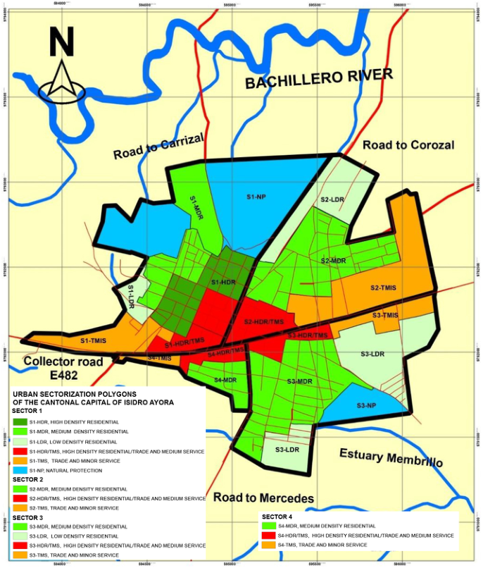
The cantonal capital of Isidro Ayora is made up of a single zone Z1 and four sectors S1 - S2 - S3 - S4, divided from east to west by the anthropic structuring “State Collector Road E-482”, which in its urban part is calls “Av. Juan Montalvo. To the north along the John F. Kennedy road towards the Corozal, San Agustín, Ciénega Redonda, Pueblo Nuevo, El Sauce and Zamora Casa de Tejas precincts and to the south along the secondary road
Figure 1: Proposal for sectorization and urban zoning polygons of the cantonal capital of Isidro Ayora. (Self elaborated).
to Rcto. The Mercedes. It has an area of 253.65 hectares with a maximum population support capacity of 22,016 habitants. Table 3 establishes each sector with its corresponding area.
With a comprehensive perspective based on sustainable development, with a vision to the year 2033, the constituent elements of the territory, its poten- tial, its risks and territorial trends were established; Table 4 and Figure 1 propose the urban zoning model for each sector with its corresponding land use and density.
CONCLUSION
The zoning proposal according to the type of urban land in the head of the canton Isidro Ayora province of Guayas, Ecuador is viable due to the fact
Zoning According to Type of Urban Land 187
that an analysis was carried out between each of the information-collection instruments (three instruments). It allowed not just contrasting it, but obtai- ning an integral perspective of the constituent elements of the territory, its potentialities, its risks, and territorial tendencies focused on in a sustainable development with a vision to 2033.
As a starting point, the current model of urban land use was established in the cantonal capital of Isidro Ayora through the municipal cadastre. This information was corroborated and complemented with the instruments and methodology applied in this proposal, which allowed establishing the results presented in the discussion section. The proposal foresees all the uses that the municipal legislative body decides is appropriate for its location in some area of the municipal area, since it foresees the intensities of use that the legis- lation considers appropriate and indicates the locations that the legislation considers for use.
REFERENCES
Brown, G., Sanders, S., & Reed, P. (2018). Using public participatory mapping to report general land use planning and zoning. Landscape and Urban Planning, 177 (January), 64–74. https://doi.org/10.1016/j.landurbplan.2018.04.011 Cabral, N. (2019). Zoning proposal based on the urban growth of the city of Piri-
bebuy, Paraguay, between 1994 and 2010. Geographic Magazine. https://doi.org/ 10.35424/regeo.v0i155.323 Cabrera, M., Plaza, M. (2016). Variables that affect the generation of irregular settlements in the peri-urban area of Cuenca: case study of rural parishes El Valle and Paccha. University of Cuenca. Cuesta, R., Villagómez, M., Dávila, Á., & Montalvo, MJ (2018). Inspired by the
Doctrine of Good Living. 18. Dalla, M. (2017). Territorial governance and Territorial Ordering Plans. Urban Territorial Log, 47(1), 47–54. https://doi.org/10.15446/bitacora.v27n1.47597 Gomez, D., & Gomez, M. (2014). Conceptual framework for territorial planning
and reflections on the Ecuadorian process in the matter. IX National Symposium on Urban Development and Territorial Planning, 21. Website: http://sndu.org/w eb/ix-simposio/ponencias/ INEN. (1988a). Mandatory Ecuadorian Technical Standard, NTE INEN 1604: Urbanization. Terminology. INEN. (1988b). Mandatory Ecuadorian Technical Standard, NTE INEN 1607:
Urbanization. Population density. Murillo A., Pin R., Vega G., Hechavarría J. (2021) Proposal for an Early Warning System for Flood Risks in the Urban Area of Cantón Milagro, Ecuador. In: Ahram T., Taiar R., Langlois K., Choplin A. ( eds ) Human interaction, emerging technolo-gies and future applications III. IHIET 2020. Advances in Intelligent Systems and Computing, vol 1253. Springer, Cham. Printed ISBN: 978-3-030- 55306-7. ISBN on-line: 978-3-030-55307-4. https://doi.org/10.1007/978-3-030- 55307-4_94 PDyOT Isidro Ayora. (2015). Development Plan and Land Management Plan of the
canton Isidro Ayora 2015–2025. Website: http://www.isidroayora.gob.ec/gaceta. html#TWO The Universe. (2013a). On the hunt for tankers due to failures in the water service in Isidro Ayora. The Universe. Website: https://www.eluniverso.com/noticias/2013/ 09/30/nota/1519726/caza-tanqueros-fallas-servicio-agua/
The Universe. (2013b). Isidro Ayora is 17 years old and has just executed some basic works. The Universe. Website: https://www.eluniverso.com/noticias/2013/ 11/22/nota/1781066/isidro-ayora-cumple-17-anos-recien-ejecuta-algunas-obra s-basicas/ The Universe. (2017). River overflow in Isidro Ayora alerts towns. The Universe.
Website: https://www.eluniverso.com/noticias/2017/02/04/nota/6030316/desbor de-rio-isidro-ayora-alerta-poblados/ The Universe. (2020). They deliver emergency kits to habitants of Isidro Ayora due to floods. The Universe. Website: https://www.eluniverso.com/guayaquil/2020/ 02/27/nota/7758813/entregan-kits-emergencia-habitantes-isidro-ayora-inundac iones/ Zambrano M., Hechavarría Hernández JR (2020) Systemic Approach to Strategic
Tourism Planning in the Cantonal Capital Bahía de Caráquez, Sucre, Ecuador. In: Ahram T., Karwowski W., Vergnano A., Leali F., Taiar R. (eds) Intelligent Human Systems Integration 2020. IHSI 2020. Advances in Intelligent Systems and Compu-ting, vol 1131. Springer, Cham. Printed ISBN: 978-3-030-39511-7. ISBN online: 978-3-030-39512-4. First online: January 22, 2020. DOI: https: //doi.org/10.1007/978-3-030-39512-4_184
LISTED IN THE AHFE DIGITAL BOOKSTORE CATALOGUE
Explore the complete digital volume
Human Factors in Architecture, Sustainable Urban Planning and Infrastructure
Read this individual research paper free through the original publisher, or explore the full digital proceedings book.
ISBN 978-1-958651-34-6
Explore this ISBN in the AHFE Bookstore ↗Listed in the July 2026 bookstore catalogue; search by ISBN to confirm current availability · Digital book purchase optional