Maria Matos Silva, Ana Beja Da Costa (2022). Lisbon’s Metropolitan Public Space Network as an opportunity for the management of the urban water cycle. In: Human Factors in Architecture, Sustainable Urban Planning and Infrastructure. AHFE Open Access, vol. 58, pp. 330–338. https://doi.org/10.54941/ahfe1002369
Stormwater management has been essentially controlled by specific technical and specialized disciplines that have authoritatively decided upon the necessary actions. An example of this is the recent Drainage Master Plan for the city of Lisbon, which mostly relies on the creation and optimization of singular, mono-functional, hard-engineering infrastructure that is uniquely focused on draining potentially valuable stormwater away from the urban area. The need to revisit contemporary practices regarding the management of pluvial waters is widely established in literature (Gersonius et al., 2013, Hartmann and Driessen, 2013), not only when considering climate change projections, and the associated exacerbation of precipitation extremes and consequent urban flooding, but also when acknowledging pluvial water as the ultimate resource for urban resilience. Faced with this challenge, numerous cities have been maturing their relationship with water through flood adaptation projects that explore water’s bountiful regenerative and ecological capacities (Matos Silva, 2020). In these projects, one can further note an attempt for a coherent elasticity and connection among similar strategies in different scales. Indeed, all flood adaptation measures are more effective and provide a broader benefit if articulated and interconnected with each other at different scales. In the research project “MetroPublicNet” (Santos et al., 2020) public space qualification projects in Lisbon Metropolitan Area since 1998 are identified and their rationales are critically revised in light of a future metropolitan public space network. Bearing in mind lessons from three specific cities (namely Rotterdam, New York, and London) regarding their relationships between existing flood adaptation strategies and metropolitan networks related to public space, this research aims to initiate the discussion on a new Metropolitan Flood Management Plan for Lisbon.Through this research, the importance of an effective interconnection between scales lies reinforced. By integrating a flood adaptation plan that is served and serves a Metropolitan Public Space Network, new urban interventions can more effectively contribute to more resilient, robust and adaptative territories.
New flood adaptation practices can be identified namely in cities such as Rot- terdam, New York, or London. All of which have specifically acknowledged
Lisbon’s Metropolitan Public Space Network as an Opportunity 331
that rigid infrastructure can no longer be the sole solution for a dynamic climate, that is expected to change in its extremes drastically and rapidly. As a result, these cities are actively searching for new flexible planning and management strategies that, while recognizing the value but also the limita- tions of mainstreamed practices, further consider climate change adaptation measures.
The currently undergoing research project “MetroPublicNet” (Santos et al., 2020), identifies and explores the experience of recent public space qualification projects in Lisbon Metropolitan Area, with a critical insight into their rationale, aims and results, and their emergent contribution towards a future metropolitan public space network. In this manuscript we specifically argue that a new Metropolitan Flood Adaptation Plan for Lisbon can be conceived in light of contemporary international practices that privilege the water cycle alongside traditional practices, articulating local to metropolitan scales though the existing network of recently intervened public spaces.
METHODOLOGY
Through literature review, this manuscript looks into three different cities, namely Rotterdam, New York and London, highlighting their existing flood adaptation strategies, from local to regional and metropolitan scales. Further- more, it considers possible associations between evidenced flood adaptation strategies and existing metropolitan networks related to public space.
The main goal of this research consists of a contribution to the systematiza- tion of identifiable “lessons learned”from these cities, that have been actively developing vanguard flood management practices that are directly and con- sciously influencing public spaces and their design. As a result, an initial theoretical background for the conceptualization of a potential Metropolitan Flood Adaptation Plan for Lisbon is anticipated. A possible territorialisation of this Plan is furthermore explored QGis software, crossing Lisbon’s Metro- politan Public Space Network, specifically the public spaces that have been intervened since 1998 (Santos et al., 2020), with its land morphology (valleys and hill-lines), and permeable areas of forest.
THE CITY OF ROTTERDAM In 2008, the “Rotterdam Climate Proof” adaptation program was launched. Regarding flood management response, this program pursued a wide range of exemplary solutions. When aiming to protect old vulnerable developments from storm surges or sea level rise, the city of Rotterdam has promoted ini- tiatives that include reinterpretations of the dikes and flood walls concepts. As an example, one may refer to the multifunctional dike of Boompjes, pro- tecting Waterstadt historical waterfront, or the levee at Hilledijk area that is envisioned to expand onto a multifunctional terraced dike, which includes a city park that connects two urban districts. In combination with the robust flood defence system, the “working with nature” paradigm is also proposed through the creation of a tidal park envisioned for the river Meuse. Parti- cularly for the outer-dike areas, measures of adaptive building and design
332 Silva and da Costa
are also reinforced, such as the local raising of property and quays or the introduction of floating buildings.
Within inner consolidated urban developments, the city has invested in measures that accommodate water arriving either from precipitation or higher water levels. Reservoirs, water plazas, the extension of the system of canals, water robust streets and infrastructure such as bioswales, water butts and green courtyards are some of the conducted investments. Related exam- ples, which are already implemented, include: the multifunctional water plaza at ‘Benthemplein’, concluded in 2013; the underground water storage under Museumpark car park in operation since 2011; or the reopened ‘Westersin- gel’ canal which can store extra water on a lower-lying sculpture terrace. Other measures that have been applied throughout the entire city include green roofs, green walls, blue roofs or collective gardens. Among the existing examples one may highlight the circa 130,000 m2 of existing green roofs, as the new large scale Dakpark roof park, located between Hudsonstraat (resi- dential street) and Vierhavensstraat, or the 5000 m2 green wall at Westblaak car park (2010).
Rotterdam’s historical background also plays a role in the uses adaptations strategies and in the opportunity for the implementation of the adaptation measures described above. The complete destruction of the city in 1940, was seen as an opportunity to plan a modern city, where housing, infrastructure, office spaces and shops were at the core of the city plans, but where public space was not taken in great consideration (Storm, 2016). This led to succes- sive redevelopment initiatives throughout the second half of the 20th century and in to the 21st century, where public space became a common ground to respond to changing needs of its inhabitants.
Whereas in most European cities, municipalities are responsible for the development and management of public space, Rotterdam is a pioneer city in delegating urban redevelopment to entrepreneurial means (Van Melik et al., 2009), and public-private partnerships. Public entities, recognizing the rele- vance of public space as a condition for showcasing Rotterdam as place for investment, enhanced public spaces attached to commercial areas or office buildings represent the core of some centralities in the city, such as the Beeurstraverse (Van Melik and Lawton, 2011).
But all of this did not solve economic inequalities and social and identity problems in this diverse city. In response to that, grassroots initiatives from local communities, facilitated by the Municipality have become a regular ‘modus operandi’, leading to local initiatives in the public space. Examples of these are the ‘City in the Making’ (Stad in de Maak), led by housing coopera- tives and open source and circular economy, or the ‘Bakens van Beverwaard’ participatory initiative, that involved residents in developing ideas for public space interventions (Storm, 2016). Other renewal initiatives fall back into the Municipality of Rotterdam agenda, which was reflected in the vision plan for the city centre ‘Inner City as City Lounge’ (Binnenstad als City Lounge 2008-2020), a vision plan that sets emphasis on public space as the central theme, through which is possible to create more balance between hard and soft mobility, improving green spaces and the waterfront (here again, facilita- ting private initiatives) (Gemeente Rotterdam, 2008). As stated by Van Melik
Lisbon’s Metropolitan Public Space Network as an Opportunity 333
and Lawton (2011) public space renewal initiatives are seen as a relevant urban renewal vector, rather than its collateral effect or final result.
THE CITY OF NEW YORK In 2007 New York municipality launched a sustainability and climate stra- tegy called the PlaNYC, which was updated in 2011, and put to the test by Hurricane Sandy in 2012 and again updated in 2013. Among the criti- cal components of the primary PlaNYC are the improvement of the City’s water quality as well as the reduction of urban vulnerabilities in the face of flooding events. Bearing in mind the existing climatic projections and ackno- wledging the fact that NY’s existing drainage was already overloaded, the hazards associated with increased runoff arose as a key concern. As a result, and namely to avoid damages associated with combined sewerage overflow (CSO) events and reduce overall vulnerabilities towards flood events, the NYC Green Infrastructure plan was launched in 2010. In essence, this plan aimed to offer an alternative to the conventional “grey” infrastructure by proposing ecosystem-based solutions such as: rooftop detention, green roofs, subsurface detention and infiltration, swales; street trees, permeable pave- ment, rain gardens, engineered wetlands, among others. The plan’s overall ambition consists of managing 10% of the runoff from impervious surfa- ces by 2030 (The City of New York, 2010). Through this strategic plan, NYC Department of Environmental Protection (DEP) has been continuously developing and implementing green infrastructure in Priority CSO Tributary Areas, namely through public on-site retrofit projects, as “right-of-way bio- swales”, and in public-private partnerships such as green infrastructure in schoolyards or green infrastructure grant programs (DEP, 2013). The subse- quent version of the PlaNYC “A Stronger, More Resilient New York” (2013), included more than 250 specific recommendations to further fortify the city against the predicted climate events. Regarding the coastal protection stra- tegy, the plan specifically focused on 1) fortifying the defence infrastructure and 2) expanding natural protections.
Among the coastal protection projects under development is the East Side Coastal Resiliency Project. The idea that guides this plan emerged from the international competition “Rebuild by Design” sponsored by the U.S. Depar- tment of Housing and Urban Development. Overall, it encompasses around 3.54 km (2.2 miles) of leveed waterfront, from Montgomery Street to East 23rd Street, reinforcing flood defence through the combination of enhanced natural areas, improved public space and facilitated littoral access. It further seeks for effective public engagement, regularly promoting public workshops and outreaches. Overall, this project envisions to benefit from the combi- ned opportunities to improve physical, social, and economic conditions while reducing the risk of flooding.
Having a long tradition of public spaces implementation and stewardship, New York’s public spaces network encompasses around 25% of the city’s total area and is considered one of the most iconic public infrastructures in the city (The City of New York, 2011) Partly publicly managed by the NYC Parks Authority, the public spaces network throughout New York’s five
334 Silva and da Costa
boroughs integrates the 2011–2013 Plan NYC strategies to address environ- mental sustainability and climate change adaptation. Adding to this, NYC Parks pledge to implement the PlanNYC strategies to integrate in its network neighbourhood parks within a ten-minute walk throughout the city, which includes public space typologies such as schoolyards, playgrounds, and green streets. Adding to the renewal and maintenance of the existing public spaces, the PlanNYC intended to target high impact projects in underserved neigh- bourhoods, to create flagship parks, converting landfills into public spaces and parks, to create a green corridors network and to promote nature prote- ction initiatives, supporting ecological connectivity (The City of New York, 2011). The Design Trust for Public Space in a coordinated effort with the City of New York Parks & Recreation Services have also set clear strategies for sustainable solutions for public spaces, publishing design guidelines for the 21st century high performance public space design (McKinney et al., 2010). NYC Parks also demonstrates to have coherent procedures in this matter, developing several initiatives and guidelines, such as a defined action-oriented framework, NYC Parks Framework (2014), or the NYC Parks Sustainable Parks Plan (The City of New York, 2010). The first contemplates strategic improvements in the public space network that aim at promoting universal access to public realm facilities, but also to ensure the quality and meaning of these spaces for local communities, through stewardship initiatives, and through coordination with federal entities that manage other public spaces in the city (NYC Parks, 2014). The latter identifies opportunities and sets clear goals for coordinated efforts for the education and outreach of the Park’s staff, for public recycling and leaf composting procedures, and for sustainable practices across park design and construction phases, through the creation of a sustainable landscape design checklist and an online reference library for sustainable design solutions (Benepe, 2012).
THE CITY OF LONDON UK’s National Adaptation Program (NAP) (HM Government, 2013) highli- ghts specific tasks for local authorities, such as: the requirement to develop and apply Local Flood Risk Management Strategies, Area Drainage Plans and Surface Water Flood Maps that incorporate evidence of future climate change; the requirement to ensure that Local Plans include measures to proactively plan to adapt to climate change; and the added responsibility to become “Sustainable Urban Drainage Systems (SUDs) Approval Bodies” being enabled to decide on the adequacy of sustainable drainage proposals for new developments (LAAP, 2013).
Looming into the case of London, one must highlight the “London Climate Change Partnership“ as the centre of expertise on climate change adaptation and resilience. Among its case studies is the “Drain London Program”, which consists of a partnership group, with the Mayor of London, Environment Agency, London Councils and Thames Water, which is responsible for mana- ging surface water, flood risk and drainage assets. In light of this program, the London Sustainable Drainage Action Plan, elaborated in 2015, includes
Lisbon’s Metropolitan Public Space Network as an Opportunity 335
the vision that “By 2040, London will manage its rainwater sustainably to reduce flood risk and improve water security, maximizing the benefits for people, the environment and the economy” (GLA, 2015). This action plan is particularly targeted at delivering sustainable drainage through new deve- lopments, through domestic and local neighbourhood measures, as well as through overall retrofitting across London. Funding opportunities and regu- larity incentives are further envisaged, as well as continued motoring. Among the implemented flood management measures within the city of London, which put great emphasis on sustainable drainage systems, are the urban retrofit at the eastern end of Derbyshire Street dead end and the urban regeneration project at Australia Road, White City.
One other interesting approach regarding flood management is the Tha- mes Estuary 2100 Plan, which adopts a particularly conservative estimate of 1.90m sea level rise scenario for the 2100 horizon. In essence, this plan assesses the flood risk within urbanized areas for the 2100 horizon, distin- guishing three different areas of action: 1) priority areas for evacuation and shelter provision; 2) areas to develop flood resilient buildings; and 3) areas to develop flood resistant buildings (EA, 2009). Moreover, it proposes a par- ticularly interesting adaptable approach for the Thames Barrier defensive infrastructure, which takes into account different possible sea level rise sce- narios through “decision pathways”. Overall, one may consider this strategic plan as an exemplary case on the adoption of the precautionary principle, as it assumes that the consequences of the failure of this specific infrastructure are much more damaging for the city than the consequences of failing by excessive caution.
The 2009 London’s Great Outdoors manifesto (Mayor of London, 2009) pledged a 220 billion pounds investments into public spaces, setting empha- sis in investments that embody London’s diversity, acknowledging that these should be accessible and open to all sorts of outdoor activities, depending on the needs of the people and the character of each place within this multi- centre city. This action refers to a coordinated effort between the East London Green Grid (Greater London Authority, 2006), the Mayor’s Great Spaces ini- tiative (Mayor of London, 2009), the Transport for London’s Major Schemes (Greater London Authority, 2018), the Street Trees program (Groundwork, 2009). Altogether aim at the general goals of reconnecting severed neighbou- rhoods, enhancing quality of life, open neglected water places for public use, improve transport hubs, improve green spaces quality, among others.
In sequence, the All London Green Grid (ALGG) (Mayor of London, 2012) is set as part of the 2011 London Plan, and adopts a strategy at a metropolitan scale to promote a shift from grey to green infrastructure, enhancing the role of the latter as fundamental to integrate multiple societal, environmental and economic benefits. Emphasis is set upon the connection between existing and proposed green spaces in a way that soft mobility, water management and ecological corridors are integrated throughout the greater London region. By securing a quality network of multifunctional green and open spaces, more accessible and attractive to commuters and outdoor users, the ALGG aims at supporting a “multi-layered landscape infrastructure and a framework for
336 Silva and da Costa
its delivery” (Mayor of London, 2012), in a coordinated effort with parallel metropolitan initiatives and strategies.
LESSONS LEARNED Considering the mentioned undertakings concerning urban flood tackling, it is possible to identify a range of common approaches that are distinguisha- ble from previously established practices. Among shared characteristics the following are worth highlighting:
hard structural engineering is not dismissed, but is reconsidered in light of new hydraulic concepts, which namely favour of the promotion of a balanced water cycle that implies more water in the city;
ecosystem-based approaches, or approaches that “work with nature”, are particularly favoured (and institutionalized) and envisioned to be applied whenever possible;
undertakings are outlined as holistic processes targeted for citywide and metropolitan implementation, yet through de-centralized small-scaled interventions;
opportunities are explored in a tailored combination of multiple benefits and in the potential synergies arising out of other urban projects;
local approaches are particularly valued, as means to favour community engagement and involvement;
continued assessment and monitoring of implemented measures is ackno- wledged as vital, namely for the encouragement of continued improve- ment; and finally,
the use of Design to connect scales, sectors, and ambitions (from indivi- duals or of a common good).
In the highlighted undertakings on metropolitan networks related to public space, it was also possible to identify a range of common characteristics that are worth emphasizing, such as:
the relying on private stakeholders and public-private partnerships for the qualification of the public space network;
the strong imprint from community’s participatory processes;
the long-lasting recognition of public space as an essential service- infrastructure for overall quality of life;
the coordination of public space management initiatives among different scales;
the reinforced need to join efforts towards climate change mitigation and adaptation approaches among different sectorial needs and agendas implied in the network of public spaces;
the acknowledgement of public space as part of a broader and multifu- nctional green infrastructure, and;
the recognition that investment on public space is as an economically competitive and socially thriving advantage for metropolitan regions.
We argue that these lessons can be considered as an initial theoretical background for the conceptualization of a potential Metropolitan Flood Ada- ptation Plan for Lisbon, bearing in mind the understanding that public space
Lisbon’s Metropolitan Public Space Network as an Opportunity 337
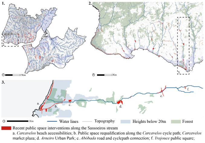
Figure 1: Preliminary territorialisation of the metropolitan flood adaptation plan for lisbon metropolitan Area 1. lisbon metropolitan area; 2. Cascais - Oeiras water stream system; 3. Sassoeiros stream.
and its design is a key component in the urban adaptation to current and expected flooding events (Matos Silva, 2020). A preliminary territorialisa- tion of this Plan is furthermore tested in QGis software. In light of previous findings, this mapping exercise crosses Lisbon’s Metropolitan Public Space Network, specifically the public spaces that have been intervened since 1998, with land morphology (valleys and hill-lines) and permeable areas of forest (Figure 1). The exercise aims to launch the discussion on a possible phy- sical and recognizable structure that can serve as a backbone to develop more concretely on the conceptualization of a Metropolitan Flood Adapta- tion Plan, namely in the identification of priority areas for intervention within its Public Space Network.
ACKNOWLEDGMENT
The authors would like to acknowledge the support of CIAUD and FCT (ref. PTDC/ART-DAQ/0919/2020) in the development of this research.
REFERENCES
Benepe, A. (2012). A Plan for Sustainable Practices within NYC Parks. New York City Department of Parks & Recreation. DEP (2013). NYC Green Infrastructure Annual Report. NYC Department of Envi-
ronmental Protection. EA (2009). TE2100 Plan Consultation Document - Managing flood risk through London and the Thames estuary. London: Environment Agency.
338 Silva and da Costa
Gemeente Rotterdam (2008). Binnenstad als City Lounge Binnenstadsplan 2008–
2020. Rotterdam. Gersonius, B., Ashley, R., Pathirana, A. & Zevenbergen, C. (2013). Climate change uncertainty: building flexibility into water and flood risk infrastructure. Climatic Change, 116, 411–423. GLA (2015). London Sustainable Drainage Action Plan. Draft for public consulta-
tion. Mayor of London. Greater London Authority. Greater London Authority. 2006. RE: East London Green Grid Primer. Greater London Authority (2018). Mayor’s Transport Strategy for London. London. Groundwork. 2009. RE: The Mayor’s Street Tree Programme. Hartmann, T. & Driessen, P. (2013). The flood risk management plan: towards spatial water governance. Journal of Flood Risk Management, 1–10. HM Government (2013). The National Adaptation Programme. Making the country
resilient to a changing climate, London: The Stationery Office, UK. LAAP (2013). Two Page Summary for Local Government. National Adaptation Programme (NAP), United Kingdom: Local Adaptation Advisory Panel. Matos Silva, M. (2020). Public Spaces for Water. A Design Notebook, CRC Press,
Taylor & Francis Group. Mayor of London (2009). London’s great outdoors. Mayor of London (2012). Green Infrastructure and Open Environments: The All London Green Grid Supplementary Planning Guidance. London. McKinney, C., Mauldin, C., Gardstein, C. & Winter, S. (eds.) (2010). High Per-
formance Landscape Guidelines 21st Century Parks for NYC A Project of the Design Trust for Public Space AND the New York City Department of Parks & Recreation, New York: Design Trust for Public Space & the City of New York. NYC Parks (2014). NYC Parks: Framework for an Equitable Future. Santos, J. R., Matos Silva, M. & et.al. (2020). MetroPublicNet - Building the foundations of a Metropolitan Public Space Network to support the robust, low-carbon and cohesive city: Projects, lessons and prospects in Lisbon. Lisbon: FCT – Funda- ção para a Ciência e Tecnologia, I.P., Ministério da Ciência, Tecnologia e Ensino Superior, Portugal, project reference. PTDC/ART-DAQ/0919/2020. Storm, W. (2016). Public Space in the Making: A Rotterdam Experiment. Streetnotes,
25. The City of New York (2010). NYC Green Infrastructure Plan. In: C. Holloway & M. R. Bloomberg (eds.). New York City. The City of New York (2011). PlaNYC A Greener, Greater New York. 1–202. Van Melik, R. & Lawton, P. (2011). The Role of Public Space in Urban Renewal
Strategies in Rotterdam and Dublin. Planning Practice and Research, 26, 513–530. Van Melik, R., Van Aalst, I. & Van Weesep, J. (2009). The private sector and public space in Dutch city centres. Cities, 26, 202–209.
LISTED IN THE AHFE DIGITAL BOOKSTORE CATALOGUE
Explore the complete digital volume
Human Factors in Architecture, Sustainable Urban Planning and Infrastructure
Read this individual research paper free through the original publisher, or explore the full digital proceedings book.
ISBN 978-1-958651-34-6
Explore this ISBN in the AHFE Bookstore ↗Listed in the July 2026 bookstore catalogue; search by ISBN to confirm current availability · Digital book purchase optional