Xiaochun Zhan, Fang Bin Guo (2022). Experiencing the History and Cultural Heritage: The Tourist Centred Map Design of Liverpool City. In: Industrial Cognitive Ergonomics and Engineering Psychology. AHFE Open Access, vol. 35, pp. 125–133. https://doi.org/10.54941/ahfe1001611
The tourist maps are geographic maps designed for tourists that indicate the narrow course of tour itineraries such as foot routes, automobile or railroad travel routes, or some combination of these. Specialised maps serve as advertisements for tourism and as a means to publicise vacation spots, sightseeing landmarks, and tourist attractions. A good specialised tour map may combine both the functions of guiding tourism and broadening tourists' horizons of regional culture and historical attractions. A usable product can assist people in decision-making process, thus, taking account of users’ requirements to create an ‘Simple Interface’ is the strategy of this map design. This paper introduces the concept of a thematic tour map design that bases on the regeneration of Liverpool Albert Dock, to reveal the scenic spots in the regenerated post-industrial zone of the city. As one of the cultural products developed in the urban regeneration project, this knowledge-oriented map design takes account of human-centred design (HCD) approach, aimed to enhance the user's interactive experience, and add commemorative value to the product. Following the theory of three levels of design: function, form, and user experience (UX). The design focuses not only on: (1) the function of the map, such as illustrating geographic/transportation information and rendering regional cultural/industrial heritage attractions, but also (2) the aesthetic styling of the product to satisfy the commemorative/collection demand of tourists; and in particular, the design emphases (3) to improve the UX through creating an ergonomic user interface (UI). Applying product semantic/semiotics principle, this tourist-centred map design has proposed to create a simple interface of the map, and with the aesthetic form of graphic presentation, thereby, to provide the users an intuitive interaction with the map that enhances the users’ experience. In this map design, the tourist information of the city was highlighted to focus on regional culture and industrial heritage presentation. The contents were categorised into geographic information and knowledge sections. The map consists of Liverpool Attractions, City Centre Map, Mersey Rail Map and Albert Dock History. Having applied the foldable concept and 3D aerial style in the map design, the product helps the users to easily carry and use. In addition, the iconic post-industrial architectures of the dock and the colour of Liverpool urban landscapes were extracted, abstracted, and applied to the map design, aimed to add commemorative value and to reflect Liverpool’s distinctive scenic spots. Having targeted both to satisfy the functional requirements of the users and to introduce necessary/relevant knowledge of the city, this knowledge-oriented thematic map design offers accurate and humanised service, so as to improve the user’s experience in travelling. This paper expects to provide designers or researchers with an example of future map design, through employing the HCD approach to create a knowledge-oriented map with an improved user experience.
Urban tourism is a comprehensive tour that integrates natural scenery, human landscape, history, and culture (Stephenson, 2008). The tourist map is a tool for tourists to discover unfamiliar areas. Its visual representation and tran- smission of systematic/ comprehensive information that helps users solve spatial positioning problems (Yan & Lee, 2015). Thus, as a guide to the information function, tourist maps should attach great importance to “com- munication”, that is, how to transmit the content of tourist attractions to readers through maps. Traditional maps placed greater emphasis on the design of functionality, practicality, accuracy, and precision, however lack of reflecting local culture and reginal history of scenic spots (Guo et al, 2008). Meanwhile, contemporary electronic maps result to the functions and market of traditional (paper-made) maps have gradually weakened (Par- sons, 2013), as powerful mapping software allows people to easily create a convincing map and graphic with little knowledge of their data, design phi- losophies or principles of mapping (Kent, 2005). Nowadays, the historical and cultural elements are becoming the significant factor of modern tourism to attract tourists. Therefore, contemporary map design no longer limited to spatial positioning but helps the users obtaining further knowledge/informa- tion from a map. The knowledge map is a blueprint to help knowledge study
(Pyo, 2005), that transmits data and information to the reader with a visual representation, thereby, enables the user learning knowledge simply through the immersive experience. Comprehending the stories of tourist destinations can also help travellers establish emotional connections with scenic spots so that their minds can be engaged in exploration (Kent, 2005).
Creativity and aesthetics are also critical factors that can improve contem- porary map design. The Aesthetic property of a map are essential for a map to be succeeded, as practicality and aesthetics are never opposites. However, the aesthetics has been largely ignored during the process of cartographic design (Field & Demaj, 2012). In fact, the aesthetic property of a map is significant to both map users and cartographers (Keates, 1984). Norman (2005) sugge- sts that attractive things work better as they bring a positive feeling to users, which makes people more creative thinking. Likewise, creativity here is an art of seeing something worth mapping is and making it visible to the rea- dership, breaking through the boundaries in design usually creates the most inspiring maps (Field & Demaj, 2012). In addition, outstanding map design will attract audiences in the competitive market, whereas poor design will lose the competition. Good design will also create its memorial significance and the value of collection. As a souvenir, a map can evoke memories of people within a place. In this case, meticulously designed knowledge commemora- tive maps with specific cultural connotations and regional characteristics will be valuable and increasingly popular.
Taking account of industrial heritage, city’s memory and history, geogra- phical advantage, social and cultural values, transforming industrial zones to different use has been an ideal option for cities’ development (Gerkan, 2004). These culture-led urban regenerations provide distinctive tourist sources for cities. The abandoned buildings/facilities with industrial heritage features or historical symbols are used to polish the cities’ image and to attract visitors (Hospers, 2002). Compared with general scenic spots, post-industrial recon- struction scenic spots demonstrate greater historical heritages and traditional culture. Having benefited from a funded project: one of the research outputs is the development of cultural products to disseminate the knowledge lear- ned from the research into the wider community, this paper introduces the design of a thematic tourist map that is based on the findings of this project, to present the urban regeneration of Liverpool city, in particular the tran- sformation of Royal Albert Dock. The objective is not only to incorporate the conventional function of a map but to provide tourists with enhanced experience in discovering the historical memory, industrial heritage, and the cultural value of the city.
STUDY AREA The city of Liverpool is located in the Northwest of England (53°25’N, 3°00’W) and on the East bank of the River Mersey. As one of the eight core cities in England, Liverpool has a population of approximately 520,000 and is the capital of Merseyside (Sykes et al, 2013). Historically, the city was one of the most important trading ports in the world, however it has gradually declined after the Second World War (Dennis, 2008). With many industrial
Experiencing the History and Cultural Heritage 127
buildings and dockside storage areas, Liverpool’s growing heritage challenges begin with key functional. In the 21st century, these old buildings have been refurbished and given new life and becoming an important asset to Liver- pool’s urban culture. The redevelopment of dock area has become a central part of the urban regeneration. Now, Liverpool is the home of Albert Dock, The Beatles, Tate Art Gallery, and the Maritime Museum (History, 2021). After a decade of regeneration, Liverpool began to exude the charm of a cul- tural city that brings economic and social benefits and pay more attention to their cultural and heritage (Kokosalakis et al, 2006).
The redevelopment of dock area has become a central part of the urban regeneration. The preservation and regeneration of Albert Dock is as exem- plary as a lighthouse in the desert. The regenerated Albert Dock has become one of the most important tourist attractions in city and is famous for its uni- que architecture and has always been a landmark of Liverpool. Those iconic buildings are very important to re-adapt to the modern economy. Therefore, the original structure and appearance of Albert Dock have been reserved as historical attractions for tourists play a new role in modern life. Nowadays, the dock is ranked as the Number One tourist attraction in Liverpool, and the favourite multi-use attraction in the United Kingdom outside London, with more than four million visitors per year (Dock, 2022).
THE CONCEPT OF MAP DESIGN Given the above, this thematic map design takes account of human-centred design (HCD) approach during the development of this cultural product. The design focuses not only on: (1) the function of the map, such as illustra- ting geographics and transportation information, rendering regional cultural and industrial heritage attractions, but also (2) aesthetic form or styling of the product to satisfy the commemorative and collection demand of tourists; and ultimately, (3) improving the user experience (UX) through creating the ergonomic user interface (UI).
The Function of the Map Traditional tour map lacks the presentation of identifiable landmarks and historical background information of the city. Therefore, this knowledge- orientated map design takes historical knowledge and landmark information into account, to display these elements in a way that conforms to the user’s cognitive habits. Functionally, the map incorporates two major sections: (a) the geographic and public services of the city, (b) the regional cultural and industrial heritage attractions.
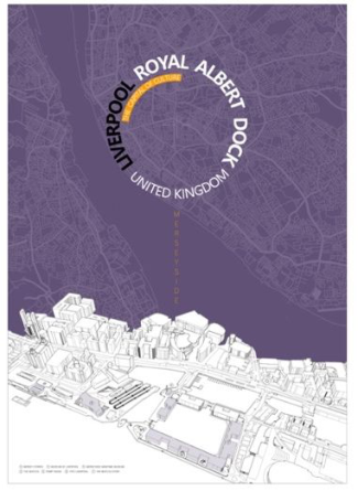
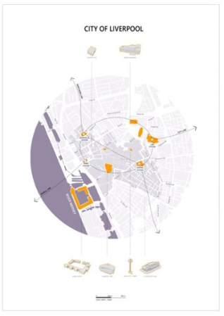
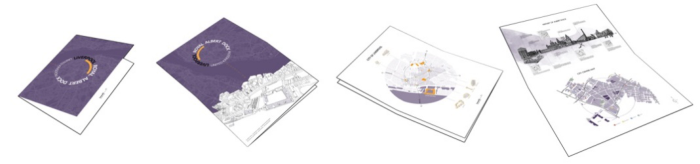
The Geographic and Public Services The cover page presents a larger-scale map of Merseyside area including the River Mersey and Liverpool City, together with a 3D view of the Albert Dock is illustrated at the bottom of the page (Figure. 1). The name of the map is positioned in the centre that outlines the two themes of this map: Liverpool city and Royal Albert Dock. The map of ‘City of Liverpool’ is positioned on the back of the cover page (Figure. 2) with a medium-level scale (1:15000)
128 Zhan and Guo
Figure 1: The cover page.Figure 2: City of Liverpool.
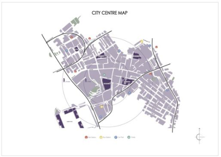
that briefly introduces the geographic information of the city such as the city centred area, the major attractions, and the train lines across the city. The small-scaled ‘City Centre Map’ (Figure. 3) is presented next to the ‘History of Albert Dock’ page displaying the streets, roads, attractions, and public servi- ces with great details. Two circular scales are centred on the map, indicating the walking time needed from one place to another.
Experiencing the History and Cultural Heritage 129
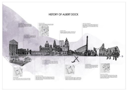
Figure 3: City Centre Map.Figure 4: History of Albert Dock.
The Regional Cultural and Industrial Heritage Attractions Liverpool has been recognised as one of the European Capitals of Cul- ture, the city is full of historical attractions, such as the Royal Albert dock that demonstrates the Liverpool’s post-industrial urban cultural identity; a range of influential bands and musicians, such as The Beatles (Cox and O’Brien, 2012). A small-scale (1:800) birds-eye view map was created using 3D software to display a realistic view of the dock and its surrounding area immersively. The major buildings and attractions are outlined by a thick line and coloured for users to easily identify. These main places of intere- sts are labelled and listed with captions (Figure. 1). A thematic tour map: the ‘History of Albert Dock’ was presented on the back of the cover page to illu- strate the historical iconic buildings, major events, and objects of the dock that follow the timeline from 1864 to present. The map is coupled with hand- drawn landmarks, historical knowledge, and the specific locations together to briefly introduce visitors with a background knowledge of each place they visit before or during their journey (Figure. 4).
130 Zhan and Guo
Figure 5: The foldable concept of the map.
The Form and Aesthetics The Graphic Layout The foldable concept of the map design was created with standard A3 sized paper (297 × 420 mm). It can be folded into a pocket-size A5 (210mm×148mm) or smaller for users to carry easily (Figure. 5). The map is divided into four A4-sized sections; each exhibiting different information individually.
The stylish cover page incorporates two images: an illustrated map and a group of 3D architectural models. A circle composed by letters is placed in the centre of the map, generating the effect of a camera lens zooming in to the city. The group of architectural models are of the Royal Albert Dock that offers the users with a bird-eye view image for a realistic presentation.
On the back of this page is a map of the major part of the city, it is designed into a circular form to echo the camera lens on the back. The map exhibits the major sights and railway lines of city. The iconic buildings and places of interest are presented through 3D illustrations.
The other side of map also includes two sections: the History of Albert Dock and City Centre Map. The history part introduces visitors with neces- sary information and knowledge of Albert Dock. A large-scale map is next to it, that displays detailed geometric information, such as, the major traffic routes, bus stations, car parks and other public services.
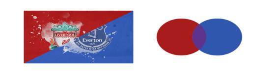
The Colour Design Colour is one of the three major factors of aesthetics in all forms of design, it expresses local cultural, regional ethnographic, city’s personality, and mea- nings. The colour of this map design intends to reflect the personality of Liverpool and to establish a distinctive image of the city. After the colour study and background research of the city, a monochromatic hue - purple (C:78 M:96 Y:5 K:1) was nominated and used with various degrees of satu- ration to establish the visual hierarchies of information display. The purple is the colour of Liverpool city, which is determined by the local council: a mix- ture of Liverpool Red and Everton Blue (Figure. 6), the two local football club colours. In addition, purple is one of the three secondary colours, which is simultaneously warm and cool. Having a balance of embodied red’s stimu- lation and blue’s calm (Ou et al, 2004), to relieve tourists’ negative emotions during their visit.
Meanwhile, the orange (C:0 M:46 Y:100 K:0) colour is technically emplo- yed to enrich the colour scheme, thereby to improve users’ visual experience.
Experiencing the History and Cultural Heritage 131
Figure 6: The colour of Liverpool city.
As the complementary colour of purple, it is not functionally creating the colour harmony, but also constructing the contrast to ensure the thematic content such as symbols and attractions being presented at the foreground of the visual hierarchy (Figure. 2).
The Simple Interface and Symbolic Design Tourist map serves tourists through transmitting the information they need to solve spatial positioning problems. A usable product can assist people in their decision-making process (Haklay and Nivala, 2010), thus, taking account of users’ requirements to create an ‘Simple Interface’ is the goal of this map design. Applying the HCD method, the design emphasises on understanding how people will use and what they expect to benefit from a map. Moreover, as a knowledge-oriented thematic map, the design targets to not only satisfy the functional requirements of the users, but also introduces necessary and relevant knowledge of the city, to offer accurate and humanised service, so as to improve the user’s experience in travelling. Given these, this concept simplifies various practical functions of the map, assures the users to read and catch the key information quickly.
Symbolic design is crucial in UI design. It acts as a language to assist users to understand the information presented on the map. Product semantics is the study of symbolic qualities of man-made shape, in the cognitive and social context of their use (Krippendorff & Butter, 1984). This knowledge helps to create quality symbols in the map design. There are two forms of symbols that were developed in this design including illustrative symbols, and 3D symbols.
The Illustrative Symbols Six iconic historical buildings and objects were selected to create illustrative symbols for the map. Having abstracted from its initial image, these illu- strative symbols were developed by hand drawing – the Procreate (a digital application) and represented artistically with black and white style to express the sense of history (Figure. 4).
The 3D Symbols Six major buildings were selected and illustrated into 3D images to produce a realistic presentation for a better recognition (Figure. 2).
DISCUSSION AND CONCLUSION Contemporary personalised tourist behaviour increasingly challenges tradi- tional tour map design. Taking the urban regeneration of Liverpool Albert
132 Zhan and Guo
Dock as an example, this paper expects to create a concept of thematic map design that combines the conventional geographic and knowledge-oriented functions together, and further strives to enhance the tourist experience and adding commemorative value to the product. Following Whitney’s (2005) theory of the ‘three levels of design’: function, form, and UX, and appl- ying product semantics and semiotics theory, this tourist-centred map design has focused on the creation of a simple interface with an aesthetic graphical presentation, so as to offer the users the intuitive interaction with the map.
It can be concluded that, the HCD method helps the design of a thematic tour map that combines the knowledge-ordinated solution to upgrade touri- sts’ experience. The contents were categorised into geographic information and knowledge sections which consists of Liverpool City Centre Map and History of Albert Dock. The colour design and the two symbolic concepts generated a simple interface for easy recognition of geometric and cultural information and added commemorative value to the map. This paper expe- cts to provide designers or researchers with an example of thematic tour map design, through employing HCD approach to create a knowledge-oriented map with an improved user experience.
ACKNOWLEDGMENT
This research has been partially supported by AHRC-Newton Fund, grant agreement number AH/S003517/1.
REFERENCES
Cox, T. and O’Brien, D. (2012). The “scouse wedding” and other myths: reflections on the evolution of a “Liverpool model” for culture-led urban regeneration. Cul- tural Trends, 21(2), 93–101. Dennis, R. (2008). Urban Regeneration and the Management of Change, Journal of
Architectural Conservation, 14(2), 83–106. Dock, T. (2022). The Royal Albert Dock. [online] VisitLiverpool. Availa- ble at: https://www.visitliverpool.com/things-to-do/the-royal-albert-dock-p16143 [Accessed 13 February 2022]. Field, K. and Demaj, D. (2012). Reasserting design relevance in cartography: some concepts. The Cartographic Journal, 49(1), 70–76. Gerkan, M. (2004). Architecture and sustainability. World Architecture, (04), 23–24. Guo, J., Gao, F. and Liu, J. (2008). On the Culture-loaded Meanings and Aesthetic
Value of Tourist Map. Bulletin of Surveying and Mapping, (03), 47-49. Hospers, G. J. (2002). Industrial heritage tourism and regional restructuring in the European Union. European Planning Studies, 10(3), 397-404. Haklay, M. and Nivala, A. M. (2010). User⣳centred design. Interacting with
geospatial technologies, 89–106. History. (2021). History. [online] Available at: https://albertdock.com/history [Accessed 21 April 2021]. Keates, J. (1984). The cartographic art. Cartographica: The International Journal for
Geographic Information and Geovisualization, 21(1), 37–43. Krippendorff, K. and Butter, R. (1984). Product Semantics-Exploring the Symbolic Qualities of Form. Departmental Papers (ASC), 40.
Experiencing the History and Cultural Heritage 133
Kent, A. J. (2005). Aesthetics: a lost cause in cartographic theory? The Cartographic Journal, 42(2), 182–188. Kokosalakis, C., Bagnall, G., Selby, M., and Burns, S. (2006). Place image and urban
regeneration in Liverpool. International Journal of Consumer Studies, 30(4), 389–397. Norman, D. (2005). Emotional design. New York: Basic Books. Ou, L. C., Luo, M. R., Woodcock, A. and Wright, A. (2004). A study of colour emotion and colour preference. Part III: Colour preference modelling. Colour Research & Application, 29(5), 381–389. Pyo, S. (2005). Knowledge map for tourist destinations—needs and implicati-
ons. Tourism Management, 26(4), 583–594. Parsons, E. (2013). The Map of the Future May Not Be a Map! The Cartographic Journal, 50(2), 182–186. Stephenson, J. (2008). The Cultural Values Model: An integrated approach to values
in landscapes. Landscape and urban planning, 84(2), 127–139. Sykes, O., Brown, J., Cocks, M., Shaw, D. and Couch, C. (2013). A city profile of Liverpool. Cities, 35, 299–318. Whitney, Patrick. (2005). The special master dialogue in North America, (Illinois
Polytechnic. School of Design: the cradle of the world’s top Design). Interviewed by Xian Bin Jiang. Yan, L. and Lee, M. Y. (2015). Are tourists satisfied with the map at hand? Current Issues in Tourism, 18(11), 1048–1058.
LISTED IN THE AHFE DIGITAL BOOKSTORE CATALOGUE
Explore the complete digital volume
Industrial Cognitive Ergonomics and Engineering Psychology
Read this individual research paper free through the original publisher, or explore the full digital proceedings book.
ISBN 978-1-958651-11-7
Explore this ISBN in the AHFE Bookstore ↗Listed in the July 2026 bookstore catalogue; search by ISBN to confirm current availability · Digital book purchase optional